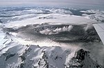
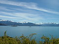
 | Mount Hudson (Spanish: Volcán Hudson, Spanish: Cerro Hudson, Monte Hudson) is a volcano in the rugged mountains of southern Chile. Lying in the Southern... 80 KB (8,899 words) - 09:12, 26 April 2024 |
 | Cerro Azul (Spanish pronunciation: [ˈsero aˈsul], blue hill in Spanish), sometimes referred to as Quizapu, is an active stratovolcano in the Maule Region... 28 KB (3,330 words) - 21:39, 7 February 2024 |
 | Nazca Plate. Other volcanoes in the area are Melimoyu, Mentolat, Cay and Cerro Hudson. Macá specifically is formed by basalt and basaltic andesite. 1,440 ±... 8 KB (784 words) - 19:09, 25 January 2024 |
 | Aguilera (volcano) (redirect from Cerro Aguilera) Lautaro lies a 300 kilometres (190 mi) long gap without volcanism and then Cerro Hudson, the southernmost volcano of the Southern Volcanic Zone. The volcano... 20 KB (2,260 words) - 16:31, 18 February 2024 |
Institution. "Spurr". Global Volcanism Program. Smithsonian Institution. "Cerro Hudson". Global Volcanism Program. Smithsonian Institution. "Pinatubo". Global... 76 KB (1,973 words) - 12:45, 7 December 2023 |
and, during historical times, the 1932 eruption of Cerro Azul and the 1991 eruption of Cerro Hudson. Mentolat is a stratovolcano which has erupted lava... 24 KB (2,684 words) - 19:41, 3 December 2023 |
 | Tláloc (section Cerro Tláloc) most specifically the sacred mountain where he was believed to reside. Cerro Tláloc is very important in understanding how rituals surrounding this deity... 42 KB (5,371 words) - 14:52, 3 April 2024 |
suggest a Holocene age. 40 kilometres (25 mi) northwest of Río Murta lies Cerro Hudson, an active arc volcano. "Rio Murta". Global Volcanism Program. Smithsonian... 4 KB (459 words) - 09:41, 5 February 2024 |
 | largest volcanic eruptions in this area were the 1932 Quizapu and the 1991 Cerro Hudson eruptions. Nevado de Longaví is usually put into the "Transitional Southern... 24 KB (2,573 words) - 13:38, 10 February 2024 |
 | 60 volcanoes in the Southern Volcanic Zone; among these are Cerro Azul and Cerro Hudson, which experienced large eruptions in 1932 and 1991 that resulted... 33 KB (3,685 words) - 13:08, 13 December 2023 |
 | the volcanism of the Andes. In the southern sector between Yate and Cerro Hudson, where Huequi is located, the crust is thin and does not heavily influence... 13 KB (1,456 words) - 14:30, 21 January 2024 |
 | Cerro El Plomo is a mountain in the Andes near Santiago, Chile. With an elevation of 5,434 m (17,783 ft), it is the largest peak visible from Santiago... 4 KB (324 words) - 16:36, 20 July 2021 |
 | Cerro Panizos is a late Miocene-age shield-shaped volcano consisting of ignimbrites, two calderas (a depression formed by the collapse of a volcano) and... 38 KB (4,541 words) - 07:02, 19 April 2024 |
 | Cerro de las Mesas, meaning "hill of the altars" in Spanish, is an archaeological site in the Mexican state of Veracruz, in the Mixtequilla area of the... 3 KB (384 words) - 00:50, 10 June 2023 |
 | Cerro Toco is a stratovolcano located in the eastern part of the Atacama desert in Chile's II Region (Antofagasta), approximately 6 km (4 mi) south of... 2 KB (151 words) - 21:49, 20 November 2023 |
 | Reclus (named after Élisée Reclus; sometimes confused with Cerro Mano del Diablo southwest of Reclus), also written as Reclús, is a volcano located in... 33 KB (3,737 words) - 05:47, 8 April 2024 |
 | Cerro Paine Grande, 2,884 m (9,462 ft) Cerro Macá, c.2,300 m (7,546 ft) Monte Darwin, c.2,500 m (8,202 ft) Volcan Hudson, c.1,900 m (6,234 ft) Cerro Castillo... 59 KB (6,858 words) - 10:44, 23 April 2024 |
Vicuñas Las Tórtolas Olivares Alto de los Leones Cerro de Los Inocentes Juncal Arenas El Morado El Plomo Cerro Leonera (4,954 m) Marmolejo Plomo Risopatrón... 9 KB (268 words) - 14:17, 13 November 2023 |
 | volcanic eruption in the region occurred 7,750 years before present at Cerro Hudson volcano, which deposited tephra all over southern Patagonia and Tierra... 36 KB (4,156 words) - 03:51, 11 March 2024 |
 | Carroll, IA Micropolitan Statistical Area Cass 13,127 564 Cedar 18,505 580 Cerro Gordo 43,127 568 Mason City, IA Micropolitan Statistical Area Cherokee 11... 327 KB (1,443 words) - 15:39, 25 April 2024 |
 | Region. It is located south of Lake Chungará and 4 km (2.5 mi) west of Cerro Capurata. The latter is part of the Nevados de Quimsachata volcano chain... 54 KB (5,891 words) - 00:00, 20 April 2024 |
 | Monte San Valentín (redirect from Cerro San Valentin) mountains in the Andes Laguna San Rafael National Park Mount Hudson Cerro Castillo Cerro Arenales List of Ultras of South America ""Argentina and Chile... 4 KB (295 words) - 20:12, 25 February 2024 |
 | Ojos del Salado (redirect from Cerro Ojos del Salado) to mineral deposits on its flanks. The mountain is often referred to as Cerro Ojos del Salado and Nevado Ojos del Salado; the former is a common term... 82 KB (9,557 words) - 09:33, 28 March 2024 |
 | $966 $970 Cass $519 $625 $715 $922 $973 Cedar $575 $601 $792 $996 $1,074 Cerro Gordo $511 $588 $775 $1,004 $1,210 Cherokee $519 $574 $715 $1,023 $1,147... 280 KB (40 words) - 22:55, 2 April 2024 |
 | Mexico desde el cerro de Atraeualco and Ajusco visto desde el Tepeyac. Finally, a personal period from 1892 to 1912, Rocas del cerro de Atzacoalco, Pirámide... 8 KB (842 words) - 17:27, 15 August 2023 |
 | Cerro del Chiquihuite (Chiquihuite Hill) is a hill located in the north of Mexico City, in the borough of Gustavo A. Madero and bordering the municipality... 14 KB (1,497 words) - 16:26, 23 November 2023 |
Cerro Guacha is a Miocene caldera in southwestern Bolivia's Sur Lípez Province. Part of the volcanic system of the Andes, it is considered to be part... 25 KB (3,121 words) - 04:50, 7 November 2023 |
Trethewey Mine Mina Proaño Naica Mine Noche Buena mine Pitarrilla mine Tayopa Cerro Colorado Mine Cliff mine Commonwealth Mine Emma Silver Mine Hercules silver... 2 KB (167 words) - 21:26, 29 January 2024 |
 | mountain and the clear air in the region make Llullaillaco visible from Cerro Paranal, 190 km away as measured through Google Maps. The view from the... 103 KB (11,587 words) - 08:43, 25 April 2024 |
 | (2008–2010) Hudson (1991) The South Volcanic Zone (SVZ) extends roughly from Central Chile's Andes at the latitude of Santiago, at ca. 33°S, to Cerro Arenales... 22 KB (2,731 words) - 03:38, 20 March 2024 |