 | tide heights. A chart datum is generally derived from some tidal phase, in which case it is also known as a tidal datum. Common chart datums are lowest astronomical... 10 KB (1,134 words) - 00:14, 27 October 2023 |
 | In geodesy, surveying, hydrography and navigation, vertical datum or altimetric datum is a reference coordinate surface used for vertical positions, such... 10 KB (1,457 words) - 13:20, 6 April 2024 |
| An ordnance datum (OD) is a vertical datum used by an ordnance survey as the basis for deriving altitudes on maps. A spot height may be expressed as above... 7 KB (777 words) - 17:44, 27 March 2024 |
 | the vertical geodetic datum accuracy of some offshore areas as represented on nautical charts, especially on small-scale charts. A similar incident involving... 17 KB (2,280 words) - 01:02, 15 September 2023 |
 | Sea level (category Vertical datums) global MSL is a type of vertical datum – a standardised geodetic datum – that is used, for example, as a chart datum in cartography and marine navigation... 23 KB (4,395 words) - 03:20, 18 April 2024 |
 | geodetic datum or geodetic system (also: geodetic reference datum, geodetic reference system, or geodetic reference frame) is a global datum reference... 29 KB (3,073 words) - 16:06, 31 December 2023 |
geometric dimensioning and tolerancing Chart datum, level of water depth on a nautical chart Datum or datum point, a (possibly arbitrary) reference baseline... 960 bytes (162 words) - 12:01, 12 December 2023 |
 | minor grid lines. A chart's data can appear in all manner of formats and may include individual textual labels describing the datum associated with the... 13 KB (1,513 words) - 17:46, 29 April 2024 |
Port Chart Datum in depth, a turning basin of 600 m in diameter and also at -18 m Port Chart Datum, 1 general cargo berth at -18 m Port Chart Datum, and... 13 KB (1,561 words) - 16:02, 26 August 2022 |
 | below" is most often noted on charts as measured from the surface of the water to the under side of the bridge at the chart datum Mean High Water (MHW), a... 5 KB (477 words) - 17:50, 24 November 2023 |
 | Additional parameters are sometimes added: The height of the light above the chart datum for height (usually based on high water). e.g. 15m for 15 metres. The... 14 KB (1,031 words) - 04:10, 10 February 2024 |
Post-glacial rebound Subsidence Tectonic uplift Vertical pressure variation Chart datum Geodesy § Heights Geographic coordinates Horizontal position Hypsometry... 8 KB (822 words) - 17:37, 6 April 2024 |
 | water levels ranged from 1.58 feet (0.48 m) to 0.33 feet (0.10 m) below Chart Datum. In the summer of 2007 monthly historic lows were set; August at 0.66... 51 KB (5,003 words) - 04:42, 24 April 2024 |
 | 86° 35' 52"W, on NOAA chart 14963, Grand Marais to Big Bay Point, scale 1:120,000, 2006. Chart datum (as shown on the chart) is 601.1 feet above mean... 44 KB (6,902 words) - 12:06, 7 March 2024 |
(5 ft 7 in) below chart datum. Dry dock number two is 120 metres (390 ft) long, 18.6 metres (61 ft) wide and a has a depth below chart datum of 0.37 metres... 12 KB (1,273 words) - 13:42, 21 August 2023 |
 | Vertical Offshore Reference Frames (category Geodetic datums) datum for hydrographic surveying and charting in the United Kingdom and Ireland. The following tidal and sea level surfaces are included: Chart Datum... 10 KB (1,013 words) - 02:21, 16 December 2023 |
 | required. A datum is a theoretically exact plane, line, point, or axis.: 3 A datum feature is a physical feature of a part identified by a datum feature... 29 KB (2,683 words) - 04:13, 18 April 2024 |
 | noon and that the water level at this time would be two metres above chart datum, and that at the following high tide the water level would be 14 metres... 10 KB (994 words) - 16:01, 13 April 2024 |
for couples who reside separately Lowest astronomical tide, a common chart datum Lath (disambiguation) Lat. (disambiguation) HHV Latency Associated Transcript... 2 KB (230 words) - 18:12, 31 March 2024 |
 | berthing for vessels up to 360m long with a water depth of 10m below Chart datum, a ferry berth, and 6.5 hectares of land for unloading, storage and industrial... 52 KB (4,857 words) - 09:38, 23 April 2024 |
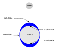 | are relative to a "chart datum", which is typically the water level at the lowest possible astronomical tide (although other datums are commonly used,... 109 KB (13,054 words) - 12:33, 17 February 2024 |
 | at suitable scales. Admiralty charts include information on: depths (chart datum), coastline, buoyage, land and underwater contour lines, seabed composition... 27 KB (3,122 words) - 11:43, 9 December 2023 |
approach charts. Vertical datum ICAO recommendations on use of the International System of Units Instrument Landing System Reference Datum Height Eurocontrol... 773 bytes (69 words) - 08:17, 26 October 2019 |
 | simply sequences of symbols that may be further interpreted formally. A datum is an individual value in a collection of data. Data is usually organized... 21 KB (2,522 words) - 09:20, 1 April 2024 |
 | Michigan is held by the state in trust for public use. Wetlands portal Chart datum Mean high water Measuring storm surge Terrace (geology), benches left... 9 KB (1,065 words) - 11:51, 14 April 2024 |
 | period, water levels ranged from 1.38 to 0.71 feet (42–22 cm) below Chart Datum. The all-time low-water mark was eclipsed in January 2013. In January... 51 KB (5,061 words) - 23:29, 21 April 2024 |
 | period, water levels ranged from 1.38 to 0.71 feet (42–22 cm) below Chart Datum. The all-time low-water mark was eclipsed in January 2013. Lake Huron... 31 KB (3,175 words) - 13:20, 27 April 2024 |
| the large geodetic systems, such as European Datum (ED50), North American Datum (NAD), and Tokyo Datum (TD), to provide a worldwide geo-data basis Need... 24 KB (2,809 words) - 05:56, 18 March 2024 |
 | cranes. The main navigation channel is dredged to 14.5 metres below chart datum, with a maximum depth of 15 metres[citation needed] alongside the quay... 19 KB (1,559 words) - 08:35, 27 March 2024 |
breakwater for berthing facilities, with an existing water depth of 6 m below chart datum. "2008 National Population and Housing Census: Preliminary Results" (PDF)... 8 KB (339 words) - 13:10, 28 March 2023 |