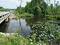
 | The Chickahominy is an 87-mile-long (140 km) river in eastern Virginia. The river, which serves as the eastern border of Charles City County, rises about... 15 KB (1,885 words) - 07:27, 14 August 2023 |
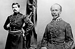
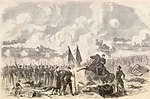 | Battle of Gaines' Mill (redirect from Battle of Chickahominy River) The Battle of Gaines' Mill, sometimes known as the Battle of Chickahominy River, took place on June 27, 1862, in Hanover County, Virginia, as the third... 33 KB (4,359 words) - 12:44, 10 February 2024 |
Chickahominy may refer to Chickahominy people, a Native American tribe Chickahominy River, a river in eastern Virginia Chickahominy, a neighborhood in... 221 bytes (54 words) - 13:04, 24 August 2020 |
Chickahominy are a federally recognized tribe of Virginian Native Americans who primarily live in Charles City County, located along the James River midway... 15 KB (1,821 words) - 15:17, 26 February 2024 |
 | Mechanicsville, Virginia (redirect from Chickahominy Middle School) southern extension, north of the Chickahominy River. The southern border of the CDP, which follows the Chickahominy, is the Henrico County line, and at... 11 KB (1,126 words) - 21:45, 28 February 2024 |
 | the river's fall line (the head of navigation). Larger tributaries draining to the tidal portion include the Appomattox River, Chickahominy River, Warwick... 25 KB (2,601 words) - 19:44, 26 April 2024 |
 | six federally recognized tribes in Virginia. They are: Chickahominy Indian Tribe Chickahominy Indian Tribe–Eastern Division Nansemond Indian Nation Pamunkey... 75 KB (5,500 words) - 00:46, 10 May 2024 |
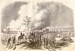 | to overwhelm two Federal corps that appeared isolated south of the Chickahominy River. The Confederate assaults, although not well coordinated, succeeded... 35 KB (4,461 words) - 00:30, 29 November 2023 |
 | the Chickahominy River, which forms the Henrico–Hanover County line. The eastern border of the CDP is Interstate 95, from the Chickahominy River south... 11 KB (846 words) - 01:07, 9 April 2024 |
 | Jamestown. It is bounded on the south by the James River and on the east by the Chickahominy River. The area that would become Charles City County was... 41 KB (4,235 words) - 22:28, 26 April 2024 |
patented 525 acres on August 8, 1653, "...lying upon the North side of Chickahominy river commonly called and known by the name of James fort...", apparently... 16 KB (2,158 words) - 22:13, 5 April 2024 |
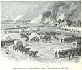
 | straddled the rain-swollen Chickahominy River, with the bulk of the army, four corps, arrayed in a semicircular line south of the river. The remainder, the V... 60 KB (8,452 words) - 09:30, 20 March 2024 |
Peninsula Campaign. While the battle at Gaines's Mill raged north of the Chickahominy River, the forces of Confederate general John B. Magruder conducted a reconnaissance... 12 KB (1,261 words) - 19:42, 12 April 2024 |
Chuckatuck Creek Brewers Creek Pagan River Warwick River Lawnes Creek Skiffes Creek College Creek Grays Creek Chickahominy River Diascund Creek Upper Chippokes... 36 KB (2,547 words) - 16:45, 3 May 2024 |
 | Chickahominy Reservoir is located near U.S. Highway 20 100 miles (160.9 km) east of Bend, Oregon, and 32 miles (51.5 km) west of Burns, Oregon, in the... 4 KB (337 words) - 14:16, 25 September 2020 |
 | Richmond. Lee attempted to turn the Union right flank, north of the Chickahominy River, with troops under Maj. Gen. Thomas J. "Stonewall" Jackson, but Jackson... 18 KB (2,156 words) - 17:50, 30 April 2024 |
 | States. The ZIP Code for Lanexa is 23089. Lanexa is located by the Chickahominy River and has many tourism sites for camping and outdoor activities. Diascund... 2 KB (145 words) - 22:58, 27 December 2023 |
 | began at the James River at Drewry's Bluff and extended counterclockwise so that his center and left were behind the Chickahominy River, a natural barrier... 57 KB (7,544 words) - 01:43, 17 April 2024 |
| located about 50 miles (80 km) west in a swamp at the head of the Chickahominy River. The modern-day interchange of Interstate 64 and Interstate 295 is... 20 KB (2,215 words) - 21:09, 26 April 2024 |
 | and his staff were reconnoitering a potential crossing point on the Chickahominy River, they stopped, and Custer overheard General John G. Barnard mutter... 109 KB (14,225 words) - 14:07, 13 May 2024 |
 | from Werowocomoco, off the York River, to Orapax (or Orapakes), located in a swamp at the head of the Chickahominy River. By 1614, Wahunsenacawh had again... 21 KB (2,434 words) - 01:20, 24 April 2024 |
Chickahominy River between Charles City County and James City County in eastern Virginia. It connects popular tourism destinations of the James River... 6 KB (606 words) - 16:15, 5 October 2022 |
 | Opechancanough captured Smith in December 1607 while he was exploring on the Chickahominy River and brought him to Powhatan's capital at Werowocomoco. In his 1608... 59 KB (6,509 words) - 15:19, 3 May 2024 |
 | Henrico County, Virginia (category Counties on the James River (Virginia)) north, and the east. The county is bounded by the Chickahominy River to the north and the James River and Richmond to the south. Richmond International... 43 KB (3,724 words) - 02:40, 27 April 2024 |
| captured by Powhatan's brother Opechancanough while foraging along the Chickahominy River, was taken to meet Powhatan in December 1607. According to Smith's... 21 KB (2,501 words) - 02:16, 20 March 2024 |
 | Thomas J. "Stonewall" Jackson's divisions were stalled north of the Chickahominy River. Union forces continued to withdraw across White Oak Swamp, abandoning... 15 KB (1,785 words) - 12:49, 10 February 2024 |
 | if the attack succeeded, Lee's right would be driven back into the Chickahominy River. Meade ordered Hancock's II Corps to shift southeast from Totopotomoy... 64 KB (8,459 words) - 16:11, 27 April 2024 |
 | to the European settlers, he captured Captain John Smith along the Chickahominy River and brought him before Chief Powhatan at Werowocomoco, one of the... 17 KB (1,509 words) - 08:17, 2 May 2024 |
 | captured Smith in December 1607 while he was seeking food along the Chickahominy River, and they took him to meet Chief Powhatan (Opechancanough's older... 63 KB (7,521 words) - 18:59, 13 May 2024 |
 | the day, Major General Edwin Vose Sumner crossed the rain-swollen Chickahominy River with two divisions. General Johnston was wounded during the battle... 141 KB (18,696 words) - 03:51, 5 May 2024 |