 | The China–Nepal border is the international boundary between the Tibet Autonomous Region of the People's Republic of China and Federal Democratic Republic... 22 KB (1,953 words) - 09:30, 13 February 2024 |
 | of the China–India border, the central segment, the China–Nepal border, the Sikkim segment of the China–India border, the China–Bhutan border, the eastern... 32 KB (616 words) - 21:13, 4 May 2024 |
 | India–Nepal border is an open international boundary running between the republics of India and Nepal. The 1,770 km (1,099.83 mi) long border includes... 18 KB (1,641 words) - 16:58, 22 April 2024 |
 | countries solved all border disputes along the China–Nepal border by signing the Sino-Nepal boundary agreement on March 21, 1960, making Nepal the first neighboring... 40 KB (4,550 words) - 08:22, 16 April 2024 |
the China–Nepal border at Gyirong–Rasuwa. As early as 1973, Mao Zedong proposed a connection between the two countries to King Birendra of Nepal in Beijing... 11 KB (1,021 words) - 05:14, 29 April 2024 |
 | defeat of Indian forces in 1962 in a border war with China, provided Nepal with the much-needed breathing space and Nepal extracted several concessions in... 58 KB (6,523 words) - 12:26, 29 April 2024 |
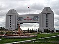
 | with the Chinese/Nepalese border at the Sino-Nepal Friendship Bridge between Zhangmu and Kodari. It includes the westernmost part of China National Highway... 5 KB (560 words) - 20:01, 21 July 2023 |
located in the country, either in whole or shared across a border with China or India. Nepal has the highest mountain in the world, Mount Everest at an... 12 KB (194 words) - 22:29, 12 April 2024 |
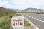
 | China National Highway 318 (G318) runs from Shanghai to Zhangmu on the China-Nepal border. It is the longest China National Highway at 5,476 kilometres... 5 KB (102 words) - 22:54, 18 June 2023 |
The Republic of India shares borders with several sovereign countries; it shares land borders with China, Bhutan, Nepal, Pakistan, Bangladesh and Myanmar... 31 KB (2,283 words) - 04:36, 4 January 2024 |
Kalapani territory (redirect from Kalapani, Nepal) Pass is where the Border Pillar number 1 of the China–Nepal border was placed, and still remains. After the 1962 border war with China, India closed the... 60 KB (5,603 words) - 06:05, 23 June 2023 |
 | Disputed territories of India (section Nepal) of China, Pakistan and Nepal. The dispute with China also involves the Republic of China based in Taiwan. India has resolved its un-demarcated border with... 39 KB (3,600 words) - 16:59, 1 May 2024 |
 | located on China's western borders. They include the world's tallest peak Mount Everest (8848 m) in the Himalayas on the border with Nepal and the world's... 51 KB (6,459 words) - 06:47, 24 April 2024 |
 | refugees in Nepal. Citizens of both countries can cross the border and travel as far as 30 km without a visa. China is viewed favourably in Nepal owing to... 237 KB (22,137 words) - 14:10, 8 May 2024 |
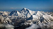 | Mount Everest (redirect from Everest, Mount (China and Nepal)) located in the Mahalangur Himal sub-range of the Himalayas. The China–Nepal border runs across its summit point. Its elevation (snow height) of 8,848... 233 KB (24,216 words) - 15:21, 8 May 2024 |
 | still reeling from ongoing landslides blocking border trade with China following the devastating 2015 Nepal earthquake. Meanwhile, none of the $4 billion... 55 KB (5,580 words) - 22:10, 2 May 2024 |
 | Korala (category China–Nepal border crossings) It currently serves as a vehicle border crossing between China and Nepal. Korala in Mustang is the fourth border point that Beijing has reopened after... 11 KB (1,095 words) - 10:46, 19 April 2024 |
 | demarcate the border. Nepali opposition claims Nepal and China have an ongoing border dispute over the territory along the Himalayan border. However, both... 40 KB (4,213 words) - 23:57, 1 April 2024 |
 | Line of Actual Control (redirect from India-China border) context of the Sino-Indian border dispute, is a notional demarcation line that separates Indian-controlled territory from Chinese-controlled territory. The... 52 KB (4,934 words) - 22:49, 16 April 2024 |
 | remains unclear. In 1955, when Nepal joined the UN, Nepal had no border disputes with either of its neighbors. Both India and China without any objections, accepted... 32 KB (2,158 words) - 21:55, 23 March 2024 |
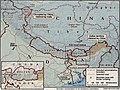
 | 155 mi) across. It has an area of 147,516 km2 (56,956 sq mi). Nepal is landlocked by China's Tibet Autonomous Region to the north and India on other three... 59 KB (5,989 words) - 17:38, 14 January 2024 |
 | India–China Border Roads (ICBRs, ICB Roads) is a Government of India project for developing infrastructure along the Sino-Indian border by constructing... 87 KB (5,294 words) - 17:07, 22 April 2024 |
 | Lomanthang Rural Municipality (category China–Nepal border crossings) Gandaki Province of western Nepal. It is located at the northern end of the district, bordering the Tibet Autonomous Region of China to the north and Dalome... 16 KB (1,194 words) - 03:21, 29 December 2023 |
 | Zhangmu (category China–Nepal border crossings) Nyalam County in Tibet, China close to the Nepal-China border, just uphill and across the Bhotekoshi River from the Nepalese town of Kodari. At 2,300... 9 KB (820 words) - 20:08, 9 April 2024 |
 | Cho Oyu (category China–Nepal border) 20 km west of Mount Everest. The mountain stands on the China Tibet–Nepal Koshi Pradesh border. Just a few kilometres west of Cho Oyu is Nangpa La (5,716m/18... 16 KB (1,538 words) - 16:39, 18 February 2024 |
 | hilsā) is a village in the northwestern corner of Nepal bordering Tibet Autonomous Region (China), where the Humla Karnali crosses from the Tibetan Plateau... 10 KB (717 words) - 15:49, 17 February 2024 |
| Birganj (India border) Bheemdatta (India border) Dhangadhi (India border) Nepalgunj (India border) Kakarbhitta (India border) Kodari (China border, opposite:... 9 KB (584 words) - 15:46, 7 May 2024 |
 | Lunag Ri (category China–Nepal border) 621 ft) high Lunag Ri is located on the Himalayan main ridge on the border between Nepal and Tibet. Lunag Ri is 11.7 km (7.3 mi) west of Cho Oyu (8,188 m... 3 KB (262 words) - 20:32, 15 March 2023 |
Kubi Gangri (category China–Nepal border) located on the international border between Nepal and Tibet, China. List of mountains in China List of mountains in Nepal List of Ultras of the Himalayas... 2 KB (80 words) - 04:43, 31 July 2022 |
 | Gaurishankar (category China–Nepal border) II: Himalaya of Nepal, Bhutan, Sikkim and adjoining region of Tibet". Peaklist.org. Retrieved 30 May 2014. "Gaurishankar, China/Nepal". Peakbagger.com... 9 KB (871 words) - 17:28, 30 March 2024 |