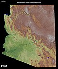
Cienega of San Simon, was a cienega, an area of springs 13 miles up the San Simon River from San Simon Station, in Cochise County, Arizona. Cienega of...
3 KB (399 words) - 18:35, 1 May 2024

historically reaching the toes of the canyon on both sides. This ciénega has since been laboriously restored. Former San Simon Ciénega on the Arizona/New Mexico...
15 KB (1,793 words) - 20:16, 12 May 2024
San Simon Cienaga, a cienega, on the San Simon River in Hidalgo County, New Mexico. U.S. Geological Survey Geographic Names Information System: San Simon...
523 bytes (47 words) - 22:49, 10 July 2021
Whitlock Valley (redirect from Whitlock Cienega, Arizona)
Whitlock Cienega Whitlock Cienega (coordinates), with San Simon Creek watershed, San Simon Valley, and Peloncillo Mountains Parks Lake University of Arizona...
5 KB (504 words) - 03:14, 6 February 2023
Creek Ciénega Creek Agua Verde Creek Davidson Canyon Mescal Arroyo Sonoita Creek Harshaw Creek San Pedro River Aravaipa Creek Babocomari River San Carlos...
5 KB (442 words) - 18:31, 17 August 2023
Valley (Arizona) C Cienega Valley (Arizona) S San Bernardino Valley San Pedro Valley (Arizona), San Pedro River (Arizona) San Simon Valley Sulphur Springs...
10 KB (197 words) - 19:08, 22 January 2023

Ciénega Creek (English: "Hundred Springs Creek" or "Marsh Creek") is an intermittent stream located in the Basin and Range region of southern Arizona,...
9 KB (958 words) - 16:55, 7 August 2023
Stein's Pass (category Landforms of Hidalgo County, New Mexico)
of forty-niners led by John Coffee Hays west from Peloncillo Ranch on Cooke's road in the Animas Valley, through this pass, to Cienega of San Simon and...
4 KB (586 words) - 01:42, 30 October 2023

largest ciénega, an isolated desert spring or marsh, remaining in the San Pedro River watershed. Its protection is important as 99% of the ciénegas in the...
27 KB (2,605 words) - 21:54, 12 May 2024
Tucson Cutoff (category Geography of Hidalgo County, New Mexico)
the west through Stein's Pass, then southwest of its mouth to the Cienega of San Simon on the San Simon River. The cutoff then ran west through Puerto...
6 KB (767 words) - 14:46, 17 March 2023

The San Francisco River is a 159-mile-long (256 km) river in the southwest United States, the largest tributary of the Upper Gila River. It originates...
2 KB (123 words) - 22:50, 8 January 2022

Hollywood Freeway (redirect from La Cienega Freeway)
Boulevard, Crescent Heights Boulevard and La Cienega Boulevard alignments of today. In fact, much of La Cienega Blvd. between Manchester Avenue and Venice...
17 KB (1,767 words) - 06:34, 22 August 2023
Tucson by way of the Puerto del Dado (Apache Pass) and Nugent’s Pass, the Cienega of San Simon, (on the river, 5 miles southwest of the mouth of Stein's Pass...
3 KB (389 words) - 21:36, 14 September 2021
North La Cienega Boulevard, Los Angeles in the U.S. state of California. In 1958, it was relocated across the street to 723 North La Cienega Boulevard...
13 KB (1,395 words) - 10:53, 29 January 2024

Los Angeles (redirect from Los Angeles, United States of America)
located at the corner of Beverly Boulevard and La Cienega before being closed and substituted by the Beverly Center. In the second half of the 20th century...
237 KB (20,076 words) - 01:56, 20 May 2024

Gila River (category Arizona placenames of Native American origin)
River and the intermittent San Simon River. Further downstream, it is joined by the San Carlos River from the north in San Carlos Lake. At Winkelman,...
22 KB (2,522 words) - 03:35, 14 April 2024

Salt River (Arizona) (category Rivers of Arizona)
boundary between the Fort Apache Indian Reservation to the north and the San Carlos Apache Indian Reservation to the south. The Salt River is fed by numerous...
19 KB (2,023 words) - 21:39, 14 February 2024
the planned Wilshire/La Cienega station, started on November 11, 2014. Section 2 pre-construction work between Wilshire/La Cienega station and Century City/Constellation...
57 KB (5,333 words) - 17:00, 30 April 2024

Santa Cruz River (Arizona) (category Rivers of Arizona)
has its headwaters in the high intermontane grasslands of the San Rafael Valley to the southeast of Patagonia, Arizona, between the Canelo Hills to the east...
12 KB (1,039 words) - 05:46, 28 November 2023

1994 Northridge earthquake (category History of the San Fernando Valley)
destroyed. Portions of a number of major roads and freeways, including Interstate 10 over La Cienega Boulevard, and the interchanges of Interstate 5 with...
46 KB (4,590 words) - 17:39, 18 April 2024

Oak Creek Canyon (category Canyons and gorges of Arizona)
Arizona between the cities of Flagstaff and Sedona. The canyon is often described as a smaller cousin of the Grand Canyon because of its scenic beauty. State...
9 KB (1,020 words) - 23:30, 19 October 2023

Chinle Creek (category Rivers of San Juan County, Utah)
Chinle Creek is a tributary stream of the San Juan River in Apache County, Arizona and San Juan County, Utah. Its source is at 36°53′40″N 109°44′37″W...
2 KB (224 words) - 13:32, 23 January 2023

Agua Fria River (category Rivers of Arizona)
south from 20 miles (32 km) east-northeast of Prescott in the U.S. state of Arizona. Prescott draws much of its municipal water supply from the upper Agua...
9 KB (460 words) - 16:43, 10 September 2023
The Rio San Bernardino, or San Bernardino River, begins in extreme southeastern Cochise County, Arizona, and is a tributary of the Bavispe River, in Sonora...
6 KB (452 words) - 18:55, 28 September 2023

Fossil Creek (category Rivers of Coconino County, Arizona)
community of Camp Verde in the U.S. state of Arizona. Primary access is from Forest Road 708 off Arizona State Route 260 east of Camp Verde. A tributary of the...
28 KB (2,874 words) - 18:32, 26 April 2024
The San Cristobal Wash is an ephemeral wash and watercourse of the San Cristobal Valley, flowing north into the Gila River Valley of the southwestern desert...
3 KB (351 words) - 03:00, 13 February 2022

Havasu Creek (redirect from Waterfalls of the Havasupai Indian Reservation)
Havasu Creek is a stream in the U.S. state of Arizona associated with the Havasupai people. It is a tributary to the Colorado River, which it enters in...
18 KB (2,129 words) - 08:31, 18 November 2023
Apache Pass (category San Antonio–San Diego Mail Line)
followed the guidance of Mexican soldiers he encountered at Ojo Ynez on the Burro Cienega in New Mexico. The cutoff emerged as part of the Southern Emigrant...
10 KB (1,494 words) - 19:05, 16 March 2023

Big Sandy River (Arizona) (category Rivers of Arizona)
converge in the Hualapai Indian Reservation east of U.S. Route 93 then flows past Wikieup south of Kingman. The Big Sandy River then passes the Signal...
10 KB (894 words) - 02:24, 22 July 2023
Nobu Matsuhisa (category Head chefs of Michelin starred restaurants)
"Mitsuwa" and "Oshou." In 1987, he opened his own restaurant "Matsuhisa" on La Cienega Boulevard in Los Angeles, California. It was in the Matsuhisa he came to...
11 KB (889 words) - 17:51, 17 April 2024