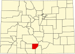
 | unincorporated community of Conejos. Being 50.7% Hispanic in 2020, Conejos was Colorado's largest Hispanic-majority county. The first European known to... 20 KB (1,863 words) - 17:11, 23 April 2024 |
 | States. The Conejos post office has the ZIP Code 81129. At the United States Census 2020, the population of the Conejos CDP was 46. Conejos is the only... 8 KB (380 words) - 19:29, 18 October 2023 |
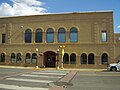
 | Manassa is a Statutory Town and is the most populous municipality in Conejos County, Colorado, United States. The town's population was 947 at the 2020 United... 32 KB (2,985 words) - 17:50, 28 April 2024 |
 | Romeo is a Statutory Town in Conejos County, Colorado, United States. The population was 302 at the 2020 census. A post office called Romeo was established... 10 KB (287 words) - 18:04, 28 April 2024 |
 | Antonito (in Spanish Antoñito) is a Statutory Town located in Conejos County, Colorado, United States. The town population was 647 at the 2020 United States... 13 KB (1,078 words) - 14:04, 28 April 2024 |
 | La Jara is a statutory town in Conejos County, Colorado, United States. The population was 730 at the 2020 United States Census. La Jara is in the San... 10 KB (273 words) - 17:48, 28 April 2024 |
 | Sanford is a statutory town in Conejos County, Colorado, United States. The population was 879 at the 2020 census. A post office called Sanford has been... 11 KB (283 words) - 19:05, 18 October 2023 |
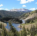
 | rises from snowmelt along the continental divide west of Conejos Peak in western Conejos County, approximately 15 miles (24 km) northeast of Pagosa Springs... 5 KB (363 words) - 23:03, 12 February 2023 |
 | Conejos County Hospital is a critical access hospital in La Jara, Colorado, in Conejos County. The hospital has 17 beds. The hospital is a Level IV trauma... 4 KB (251 words) - 02:28, 13 February 2023 |
Conejos is the Spanish term for "rabbits". It may refer to: Conejos River Conejos, Colorado Conejos County, Colorado Conejo (disambiguation) This disambiguation... 394 bytes (54 words) - 18:49, 6 December 2018 |
 | X Y Z Acascosa Lake in Conejos County, Colorado Antero Reservoir in Park County, Colorado Aurora Reservoir in Aurora, Colorado Barbour Ponds in Saint... 10 KB (1,161 words) - 15:05, 17 March 2024 |
 | and a census-designated place (CDP) located in and governed by Conejos County, Colorado, United States. The Capulin post office has the ZIP Code 81124... 8 KB (320 words) - 19:15, 18 October 2023 |
 | municipality in the county is Pagosa Springs. Archuleta County was created by the Colorado legislature on April 14, 1885, out of western Conejos County. It was named... 14 KB (886 words) - 17:10, 23 April 2024 |
 | Cumbres and Toltec Scenic Railroad (redirect from Windy Point, Conejos County) Historic Places listings in Colorado § Archuleta County National Register of Historic Places listings in Conejos County, Colorado National Register of Historic... 41 KB (4,544 words) - 19:43, 14 March 2024 |
 | San Luis Valley (category Landforms of Conejos County, Colorado) Mountains. Within Colorado the San Luis Valley is generally considered to comprise six Colorado counties: Saguache, Alamosa, Rio Grande, Conejos, Costilla and... 43 KB (5,186 words) - 16:53, 17 April 2024 |
 | water. Saguache County, Colorado - north Huerfano County, Colorado - east Costilla County, Colorado - southeast Conejos County, Colorado - southwest Rio... 14 KB (922 words) - 17:10, 23 April 2024 |
Acascosa Lake (category Lakes of Conejos County, Colorado) Acascosa Lake /ɑːkəˈskoʊsə/ is a lake in Conejos County, Colorado, United States. Its surface elevation is 10,984 feet (3,348 m). The name "Acascosa" probably... 2 KB (86 words) - 22:47, 8 May 2021 |
 | Pike's Stockade (category Buildings and structures in Conejos County, Colorado) National Historic Landmarks in Colorado National Register of Historic Places listings in Conejos County, Colorado "Conejos County: Sanford". National and State... 5 KB (409 words) - 21:24, 8 August 2023 |
 | a list of the National Register of Historic Places listings in Conejos County, Colorado. This is intended to be a complete list of the properties and districts... 7 KB (343 words) - 16:22, 31 May 2023 |
census-designated place La Jara (comarca), Spain La Jara Reservoir, in Conejos County, Colorado, United States This disambiguation page lists articles about distinct... 400 bytes (70 words) - 21:29, 5 November 2023 |
 | Rio Grande (category Rivers of Conejos County, Colorado) resources data for the United States, Water Year 2009; gage 08249000, Conejos River near Lasauses, CO" (PDF). United States Geological Survey. Archived... 56 KB (5,482 words) - 02:11, 26 April 2024 |
 | Cumbres Pass (category Landforms of Conejos County, Colorado) elevation 10,022 ft (3,055 m), is a mountain pass in the San Juan Mountains in Colorado, United States. The pass is traversed by State Highway 17 and the Cumbres... 6 KB (445 words) - 04:54, 9 February 2024 |
 | Miguel County, Colorado since the county was created on March 2, 1883. In 1863, county voters selected Conejos as the seat of Conejos County, Colorado Territory... 310 KB (2,894 words) - 13:12, 7 January 2024 |
 | highway in Colorado that starts at the New Mexico state line and ends at I-25, US 87, and SH 30 in Denver. Heading north from the Colorado border, US... 13 KB (532 words) - 07:53, 27 April 2024 |
| This list ranks the 64 counties of the U.S. State of Colorado by population as of July 1, 2023, as estimated by the United States Census Bureau. This list... 29 KB (372 words) - 22:41, 20 March 2024 |
 | miles (19 km), at the Rio Grande-Conejos county line, there exists an 8-mile (13 km) gap filled in by Conejos County Route 6. After the gap, SH 15 reappears... 4 KB (204 words) - 03:46, 9 November 2023 |
 | south Sandoval County - south San Juan County - west Archuleta County, Colorado - north Conejos County, Colorado - north Carson National Forest (part)... 23 KB (1,775 words) - 14:49, 26 April 2024 |
 | Cumbres Pass in Conejos County, Colorado, United States. The summit of Conejos Peak is the highest point in Conejos County. Colorado portal Mountains... 3 KB (162 words) - 04:28, 5 February 2022 |
 | Rio San Antonio is a tributary of the Conejos River in northern New Mexico and southern Colorado. Via the Conejos River, it is part of the upper Rio Grande... 6 KB (424 words) - 00:34, 1 November 2021 |
 | Platoro is an unincorporated community in Conejos County, in the U.S. state of Colorado. A post office called Platoro was established in 1888, and remained... 1 KB (121 words) - 17:52, 10 November 2023 |