 | In geometry, a coordinate system is a system that uses one or more numbers, or coordinates, to uniquely determine the position of the points or other... 19 KB (2,265 words) - 23:43, 7 January 2024 |
 | In geometry, a Cartesian coordinate system (UK: /kɑːrˈtiːzjən/, US: /kɑːrˈtiːʒən/) in a plane is a coordinate system that specifies each point uniquely... 40 KB (5,501 words) - 11:14, 16 April 2024 |
| In mathematics, a spherical coordinate system is a coordinate system for three-dimensional space where the position of a given point in space is specified... 42 KB (6,283 words) - 18:04, 20 April 2024 |
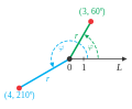 | In mathematics, the polar coordinate system is a two-dimensional coordinate system in which each point on a plane is determined by a distance from a reference... 47 KB (6,600 words) - 02:28, 5 April 2024 |
 | A geographic coordinate system (GCS) is a spherical or geodetic coordinate system for measuring and communicating positions directly on the Earth as latitude... 21 KB (2,380 words) - 18:12, 4 April 2024 |
 | The galactic coordinate system is a celestial coordinate system in spherical coordinates, with the Sun as its center, the primary direction aligned with... 14 KB (1,388 words) - 04:59, 5 April 2024 |
 | The equatorial coordinate system is a celestial coordinate system widely used to specify the positions of celestial objects. It may be implemented in spherical... 17 KB (1,657 words) - 17:32, 14 April 2024 |
 | A cylindrical coordinate system is a three-dimensional coordinate system that specifies point positions by the distance from a chosen reference axis (axis... 18 KB (2,136 words) - 15:21, 27 February 2024 |
 | In astronomy, the ecliptic coordinate system is a celestial coordinate system commonly used for representing the apparent positions, orbits, and pole orientations... 14 KB (1,331 words) - 17:44, 18 April 2024 |
 | The horizontal coordinate system is a celestial coordinate system that uses the observer's local horizon as the fundamental plane to define two angles:... 9 KB (900 words) - 07:17, 15 March 2024 |
 | A projected coordinate system – also called a projected coordinate reference system, planar coordinate system, or grid reference system – is a type of... 21 KB (2,802 words) - 02:18, 12 April 2024 |
The Swiss coordinate system (or Swiss grid) is a geographic coordinate system used in Switzerland and Liechtenstein for maps and surveying by the Swiss... 7 KB (968 words) - 17:51, 30 December 2023 |
 | In geometry, the elliptic coordinate system is a two-dimensional orthogonal coordinate system in which the coordinate lines are confocal ellipses and... 9 KB (1,599 words) - 16:25, 17 November 2023 |
| A spatial reference system (SRS) or coordinate reference system (CRS) is a framework used to precisely measure locations on the surface of Earth as coordinates... 15 KB (1,546 words) - 22:10, 9 April 2024 |
 | In astronomy, coordinate systems are used for specifying positions of celestial objects (satellites, planets, stars, galaxies, etc.) relative to a given... 28 KB (3,948 words) - 03:55, 7 April 2024 |
 | In geometry, a barycentric coordinate system is a coordinate system in which the location of a point is specified by reference to a simplex (a triangle... 44 KB (8,017 words) - 20:34, 18 April 2024 |
 | various galaxies defined in 1976 the equator of the supergalactic coordinate system de Vaucouleurs developed. In years thereafter with more observation... 7 KB (861 words) - 01:41, 24 November 2023 |
 | The selenographic coordinate system is used to refer to locations on the surface of Earth's moon. Any position on the lunar surface can be referenced... 5 KB (573 words) - 11:32, 26 February 2024 |
 | A planetary coordinate system (also referred to as planetographic, planetodetic, or planetocentric) is a generalization of the geographic, geodetic, and... 19 KB (2,103 words) - 21:58, 23 February 2024 |
| was used. The World Geodetic System WGS84 ellipsoid is now generally used to model the Earth in the UTM coordinate system, which means current UTM northing... 17 KB (2,610 words) - 23:05, 29 February 2024 |
The State Plane Coordinate System (SPCS) is a set of 125 geographic zones or coordinate systems designed for specific regions of the United States. Each... 7 KB (965 words) - 15:06, 26 February 2024 |
 | The perifocal coordinate (PQW) system is a frame of reference for an orbit. The frame is centered at the focus of the orbit, i.e. the celestial body about... 6 KB (1,037 words) - 19:05, 16 October 2023 |
 | The sigma coordinate system is a common coordinate system used in computational models for oceanography, meteorology and other fields where fluid dynamics... 5 KB (511 words) - 09:39, 15 May 2023 |
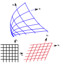 | Curvilinear coordinates (redirect from Curvilinear coordinate system) In geometry, curvilinear coordinates are a coordinate system for Euclidean space in which the coordinate lines may be curved. These coordinates may be... 52 KB (8,289 words) - 04:14, 27 February 2024 |
The Hexagonal Efficient Coordinate System (HECS), formerly known as Array Set Addressing (ASA), is a coordinate system for hexagonal grids that allows... 14 KB (1,778 words) - 14:22, 7 November 2023 |
 | Earth-fixed coordinate system (acronym ECEF), also known as the geocentric coordinate system, is a cartesian spatial reference system that represents... 9 KB (904 words) - 13:39, 7 January 2024 |
In solar observation and imaging, coordinate systems are used to identify and communicate locations on and around the Sun. Since the Sun is gaseous in... 8 KB (751 words) - 19:12, 4 April 2024 |
phrase machine coordinate system refers to the physical limits of the motion of the machine in each of its axes, and to the numerical coordinate which is assigned... 3 KB (484 words) - 02:16, 23 February 2023 |
 | displacement from a reference position in a three-dimensional Cartesian coordinate system (i.e., with XYZ axes). In addition to moving the probe along the X... 19 KB (2,612 words) - 13:28, 28 March 2024 |
geographic coordinate systems is made necessary by the different geographic coordinate systems in use across the world and over time. Coordinate conversion... 34 KB (5,145 words) - 23:49, 2 December 2023 |