 | The Crowsnest River is a tributary to the Oldman River in southwestern Alberta, Canada. From its source in Crowsnest Lake at an elevation of about 1,357... 2 KB (164 words) - 16:14, 24 November 2023 |
 | 510 ft). Crowsnest Pass comprises a valley running east–west through Crowsnest Ridge. On the Alberta side, the Crowsnest River flows east from Crowsnest Lake... 11 KB (1,172 words) - 04:50, 30 December 2023 |
 | Alberta Highway 3 (redirect from Crowsnest Trail) officially named the Crowsnest Highway, is a 324-kilometre (201 mi) highway that traverses southern Alberta, Canada, running from the Crowsnest Pass through Lethbridge... 78 KB (7,436 words) - 02:25, 8 November 2023 |
 | an armed standoff. The dam was constructed where the Oldman, Crowsnest, and Castle river systems converge. On June 21, 2013, during the 2013 Alberta floods... 7 KB (505 words) - 04:39, 16 December 2023 |
 | located in the Crowsnest River Valley and is part of the Blairmore Range of the Canadian Rockies. The headwaters of the Oldman River are found here.... 4 KB (426 words) - 17:44, 11 July 2023 |
 | Municipality of Crowsnest Pass is a specialized municipality in southwest Alberta, Canada. Within the Rocky Mountains adjacent to the eponymous Crowsnest Pass,... 24 KB (1,583 words) - 18:40, 20 September 2023 |
Crows Nest (redirect from Crowsnest) Alberta–British Columbia border, Canada Crowsnest Mountain Crowsnest Provincial Park Crowsnest River, Alberta, Canada Crow's Nest (Hong Kong), a hill Crow's... 1 KB (244 words) - 14:40, 24 November 2021 |
 | The Crowsnest Highway is an east-west highway in British Columbia and Alberta, Canada. It stretches 1,161 km (721 mi) across the southern portions of... 21 KB (1,532 words) - 19:12, 17 February 2024 |
 | Lundbreck Falls (category Alberta river stubs) the Crowsnest River located in southwestern Alberta, Canada near the hamlet of Lundbreck. It is adjacent to the Highway 3A crossing of the Crowsnest River... 2 KB (139 words) - 05:21, 4 December 2023 |
 | Frank Slide (category Crowsnest Pass, Alberta) speed ahead and sped his train to safety across the bridge over the Crowsnest River. At 4:10 am, 30 million cubic metres of limestone rock with a mass... 31 KB (3,630 words) - 15:08, 5 March 2024 |
 | Slave Lake and Mackenzie River, except for Petitot River which is drained through Liard River directly into the Mackenzie River, thus bypassing the Great... 10 KB (271 words) - 23:18, 5 April 2024 |
 | Crowsnest Mountain is a mountain in the southern Canadian Rockies of southwestern Alberta, Canada. It can be seen from Alberta Highway 3 west of the town... 4 KB (314 words) - 23:55, 27 September 2022 |
| summit of the Crowsnest Pass in the southern Canadian Rockies and gives rise to the Crowsnest River. Canada NTS Map 82G/10 Crowsnest, 1:50,000. v t e... 2 KB (41 words) - 20:40, 26 December 2023 |
British Columbia Highway 3, officially named the Crowsnest Highway, is an 841-kilometre (523 mi) highway that traverses southern British Columbia, Canada... 29 KB (2,203 words) - 20:35, 10 April 2024 |
Moyie River northeast for 11 km (7 mi) to the town of Yahk, where it merges onto the Crowsnest Highway (Highway 3). Highway 95 follows the Crowsnest Highway... 11 KB (684 words) - 17:16, 29 March 2023 |
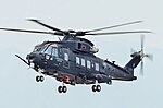 | AgustaWestland AW101 (redirect from Merlin HM2 Crowsnest) and mission system for the Crowsnest. Initial operating capability of the system was significantly delayed. While Crowsnest was deployed with the U.K.... 114 KB (10,639 words) - 14:11, 17 March 2024 |
 | Deer to Crowsnest". Calgary Sun. p. 3. "Hydroelectric Facilities". TransAlta. 2020. Archived from the original on January 25, 2021. "Bow River Reservoir... 46 KB (4,907 words) - 02:23, 10 July 2023 |
Highway 22, west of Lundbreck. This 3.6 km (2.2 mi) segment crosses the Crowsnest River and provides a viewing opportunity of Lundbreck Falls. The highway... 7 KB (499 words) - 00:08, 1 October 2021 |
 | on the Elk River, along Canada's southernmost east-west transportation corridor through the Rockies that crosses the range via the Crowsnest Pass, 40 kilometres... 34 KB (2,227 words) - 16:38, 19 February 2024 |
in the province. The Crowsnest Highway (Highway 3) runs from Hope, then through Osoyoos, Castlegar, Cranbrook, right to Crowsnest Pass on the BC/Alberta... 93 KB (1,311 words) - 03:39, 16 April 2024 |
 | Crow Rate (redirect from Crowsnest Freight Rate) British Columbia through the Crowsnest Pass, which would also enable the development of coal deposits in the Pass and the Elk River valley, important both for... 4 KB (425 words) - 16:41, 19 May 2021 |
that it connects with at the Canada–United States border. It follows the Crowsnest Highway (Highway 3) and Highway 95 through Radium Hot Springs and to where... 10 KB (645 words) - 22:55, 22 September 2022 |
 | Osoyoos (category British Columbia populated places on the Okanogan River) on the east-west Crowsnest Highway (Highway 3) with a significant ascent out of the Okanagan Valley in either direction. The Crowsnest headed east begins... 30 KB (2,450 words) - 10:09, 27 March 2024 |
 | Baillie-Grohman". www.crowsnest-highway.ca. Archived from the original on 2021-10-19. Retrieved 2021-11-21. "Creston's Early Pioneers". www.crowsnest-highway.ca... 53 KB (3,846 words) - 00:07, 23 February 2024 |
 | Mount Tecumseh (Alberta) (category Crowsnest Pass, Alberta) tributaries of the nearby Crowsnest River. Topographic relief is significant as the summit rises nearly 1,200 metres (3,900 ft) above Crowsnest Lake in three kilometres... 6 KB (480 words) - 19:11, 7 April 2024 |
Crowsnest Ridge is located on the border of Alberta and British Columbia on the Continental Divide. List of peaks on the Alberta–British Columbia border... 1 KB (47 words) - 06:21, 30 October 2023 |
 | Chinook Peak (Alberta) (category Crowsnest Pass, Alberta) tributaries of the nearby Crowsnest River. Topographic relief is significant as the summit rises 1,300 meters (4,265 feet) above the river in 4.5 kilometers (2... 5 KB (422 words) - 18:12, 20 September 2023 |
 | Sentry Mountain (category Crowsnest Pass, Alberta) headwaters of the Crowsnest River. Topographic relief is significant as the summit rises 1,080 meters (3,543 feet) above Crowsnest Lake in 1.5 kilometer... 6 KB (482 words) - 10:05, 24 November 2023 |
 | Seven Sisters Mountain (category Crowsnest Pass, Alberta) east to McGillivray Creek which are both tributaries of the nearby Crowsnest River. Topographic relief is significant as the summit rises 870 metres (2... 6 KB (508 words) - 01:47, 25 July 2023 |
 | Labrador. Highway 1 (Transcanada Highway) Highway 2 (QE2) Highway 3 (Crowsnest Highway) Highway 4 Highway 5 Highway 36 (Veteran Memorial Highway) Highway 41... 8 KB (464 words) - 18:52, 11 October 2023 |