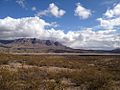
 | The Doña Ana Mountains are a mountain range in Doña Ana County, New Mexico. The highest elevation in the range is Doña Ana Peak at 5,835 feet (1,779 meters)... 4 KB (524 words) - 03:25, 11 May 2023 |
 | Doña Ana County (Spanish: Condado de Doña Ana) is located in the southern part of the State of New Mexico, United States. As of the 2020 U.S. Census,... 24 KB (2,162 words) - 14:48, 26 April 2024 |
 | Doña Ana is a census-designated place (CDP) in Doña Ana County, New Mexico, United States. The population was 1,211 at the 2010 census. Doña Ana is named... 9 KB (751 words) - 23:19, 4 May 2024 |
 | San Andres Mountains are a mountain range in the southwestern U.S. state of New Mexico, in the counties of Socorro, Sierra, and Doña Ana. The range extends... 6 KB (469 words) - 00:21, 17 February 2023 |
Mountains Crosby Mountains Datil Mountains Diablo Range Doña Ana Mountains East Potrillo Mountains Elk Mountains Fernando Mountains Florida Mountains Fra Cristobal... 5 KB (376 words) - 10:02, 7 January 2023 |
 | national monument are the Robledo Mountains, Sierra de las Uvas, Doña Ana Mountains, Organ Mountains and Potrillo Mountains. The Prehistoric Trackways National... 7 KB (583 words) - 05:58, 22 November 2023 |
Cerro Doña Ana is a mountain in the Andes of Chile. It has a height of 5648 meters. List of mountains in the Andes Dell´Orto S., Adolfo (13 May 2003)... 651 bytes (62 words) - 04:48, 21 March 2024 |
 | of the city of Las Cruces, in Doña Ana County. The Organ Mountains are near the southern end of a long line of mountains on the east side of the Rio Grande's... 10 KB (1,058 words) - 20:27, 26 January 2024 |
 | Kilbourne Hole (category Landforms of Doña Ana County, New Mexico) 30 miles (48 km) west of the Franklin Mountains of El Paso, Texas, in the Potrillo volcanic field of Doña Ana County, New Mexico. Another maar, Hunt's... 11 KB (1,188 words) - 09:24, 22 February 2024 |
 | Las Cruces, New Mexico (category Cities in Doña Ana County, New Mexico) and the seat of Doña Ana County. As of the 2020 census the population was 111,385. Las Cruces is the most populous city in both Doña Ana County and southern... 86 KB (7,942 words) - 16:26, 26 April 2024 |
 | northward up through a gap, between the Selden Hills on the west and Doña Ana Mountains to the east, on to the plain of the Jornada. The last opportunity... 22 KB (2,588 words) - 12:34, 20 March 2024 |
 | namely the Animas, San Andres, and Doña Ana Mountains in New Mexico; and the Franklin, Hueco, and Davis Mountains in Texas. It also reaches up into the... 130 KB (12,482 words) - 23:28, 7 May 2024 |
 | Mogollon-Datil volcanic field: Bursum Emory Organ (Las Cruces, Doña Ana Mountains, Organ Mountains) Socorro calderas The Jemez Lineament: San Carlos volcanic... 21 KB (2,287 words) - 07:57, 22 April 2024 |
 | The Caballo Mountains, (Spanish: "horse") are a mountain range located in Sierra and Doña Ana Counties, New Mexico, United States. The range is located... 18 KB (2,239 words) - 09:45, 9 June 2022 |
 | Santa Teresa, New Mexico (category Census-designated places in Doña Ana County, New Mexico) incorporation petition with Dona Ana County clerk". KFOX. Retrieved September 27, 2019. D'Ammassa, Algernon (September 25, 2019). "Doña Ana County kicks Santa... 10 KB (798 words) - 16:36, 16 February 2024 |
Barbee Draw (category Landforms of Doña Ana County, New Mexico) Barbee Draw is a valley and an arroyo tributary to the Rincon Arroyo in Doña Ana and Sierra County, New Mexico. Barbee Draw heads at an elevation of 6,800... 1 KB (127 words) - 17:17, 22 January 2023 |
 | Chaparral, New Mexico (category Census-designated places in Doña Ana County, New Mexico) geographically isolated from the rest of Doña Ana County due to its location on the east side of the Franklin Mountains. Downtown El Paso, Texas is 20 miles... 10 KB (852 words) - 18:10, 13 September 2023 |
 | Tortugas Mountain is a mountain in southern New Mexico, in the village of Tortugas in Doña Ana County, New Mexico. It is also known locally as 'A' Mountain. There... 5 KB (143 words) - 01:40, 16 March 2024 |
 | White Sands, New Mexico (category Census-designated places in Doña Ana County, New Mexico) White Sands is a census-designated place (CDP) in Doña Ana County, New Mexico, United States. It consists of the main residential area on the White Sands... 11 KB (1,078 words) - 00:25, 6 March 2024 |
Sierra de las Uvas (category Mountain ranges of Doña Ana County, New Mexico) The Sierra de las Uvas or Grape Mountains are a mountain range in Doña Ana County, New Mexico. The John D. Dingell, Jr. Conservation, Management, and Recreation... 2 KB (121 words) - 06:08, 17 September 2020 |
 | Gabriel Mountains National Monument". whitehouse.gov. October 10, 2014. Retrieved October 10, 2014 – via National Archives. "San Gabriel Mountains National... 143 KB (3,779 words) - 15:01, 3 May 2024 |
Picacho Mountain, also known as El Picacho and Picacho Peak, is a summit in Doña Ana County, New Mexico. It rises to an elevation of 4,954 feet / 1,510... 526 bytes (60 words) - 22:54, 28 June 2023 |
 | The Robledo Mountains are a mountain range in Doña Ana County, New Mexico, just northwest of Las Cruces. They are an uplifted block of Paleozoic rocks... 3 KB (322 words) - 14:16, 24 May 2023 |
San Diego Mountain also known as Tonuco Mountain is an American summit 22 miles northwest of Las Cruces, New Mexico in Doña Ana County. Its summit is... 2 KB (337 words) - 14:18, 17 March 2023 |
 | Interstate 10 in New Mexico (category Transportation in Doña Ana County, New Mexico) I-10 traverses southern New Mexico through Hidalgo, Grant, Luna, and Doña Ana counties. The interstate travels west–east from the Arizona state line... 14 KB (833 words) - 18:51, 5 May 2024 |
 | Organ Needle (category Mountains of Doña Ana County, New Mexico) the highest point of the Organ Mountains in the south-central part of the U.S. state of New Mexico. It lies in Doña Ana County, 13 miles (20,921 m) east-northeast... 2 KB (220 words) - 21:30, 19 January 2021 |
 | Organ, New Mexico (category Census-designated places in Doña Ana County, New Mexico) Organ is an unincorporated community and census-designated place in Doña Ana County, New Mexico, United States. As of the 2010 census, its population was... 8 KB (667 words) - 21:43, 12 July 2023 |
 | Anthony, New Mexico (category Cities in Doña Ana County, New Mexico) Anthony is a city in Doña Ana County, New Mexico, United States. The population was 9,360 at the 2010 census. It is located on the New Mexico–Texas state... 12 KB (871 words) - 16:53, 6 May 2024 |
Gracia Mendes Nasi (redirect from Doña Gracia Nasi) the wealthiest Jewish women of Renaissance Europe. She was also known as Doña Gracia, La Señora ("The Lady" in Spanish), and her Christianised name Beatriz... 20 KB (2,565 words) - 18:18, 2 May 2024 |
 | the Kid. He was the sheriff of Lincoln County, New Mexico, as well as Doña Ana County, New Mexico. Patrick Floyd Jarvis Garrett was born on June 5, 1850... 35 KB (4,442 words) - 13:18, 7 May 2024 |