 | Retrieved February 1, 2023. "Hell Creek State Park Master Site & Management Plan" (PDF). Montana Fish, Wildlife & Parks. December 7, 2015. Retrieved... 4 KB (234 words) - 19:29, 30 December 2023 |
2018. "Fish Creek State Park Draft Management Plan". Montana Fish, Wildlife & Parks. December 2013. p. 13. Retrieved June 24, 2020. Fish Creek State Park... 4 KB (253 words) - 22:14, 1 August 2023 |
 | protected lands and recreational areas, including five state wilderness areas, six interpretive areas, and a wildlife management area. Two state parks— Edgar Evins... 10 KB (946 words) - 06:05, 15 November 2020 |
protected area to the Charles M. Russell National Wildlife Refuge, and turned the area over to the U.S. Fish and Wildlife Service for management. Two important... 34 KB (4,546 words) - 22:33, 14 March 2023 |
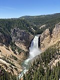 | Yellowstone National Park (redirect from Wildlife of Yellowstone National Park) Leopold, A. Starker; et al. (1963). "The Goal of Park Management in the United States". Wildlife Management in the National Parks. National Park Service. Archived... 163 KB (15,753 words) - 15:24, 25 April 2024 |
 | American Prairie (category Protected areas of Blaine County, Montana) prairie ecosystem with migration corridors and native wildlife. This wildlife conservation area is being developed as a private project of the American... 60 KB (5,651 words) - 06:22, 23 November 2023 |
 | Halifax River (section Wildlife Viewing) birds, fish, and other wildlife. The river and several of its tributaries (Tomoka River, Strickland, Thomson and Dodson Creek) are designated as a Manatee... 21 KB (2,502 words) - 22:51, 26 January 2024 |
Amelia Island Wildlife Management Area, also referred to as Amelia Island, is a 238 acres (96 ha) tract of protected land located in Treasure County, Montana... 2 KB (178 words) - 02:59, 3 February 2023 |
 | Cane Creek Gorge, an area known for its unique geological formations and scenic waterfalls. The park's namesake is the 256-foot (78 m) Fall Creek Falls... 20 KB (2,386 words) - 04:06, 12 March 2024 |
 | CSKT Bison Range (redirect from National Bison Range Wildlife Refuge) National Wildlife Refuge in 1908, the BR consists of approximately 18,524 acres (7,496 ha) within the Montana valley and foothill grasslands. Management of... 28 KB (2,707 words) - 01:20, 29 January 2024 |
 | Multnomah Falls (redirect from Multnomah Creek Bridge) is a waterfall located on Multnomah Creek in the Columbia River Gorge, east of Troutdale, between Corbett and Dodson, Oregon, United States. The waterfall... 24 KB (2,412 words) - 15:48, 27 February 2024 |
 | Glacier National Park (U.S.) (redirect from Wildlife of Glacier National Park (U.S.)) populate certain areas of the park. Reports from state and federal resource agencies, such as the Montana Department of Fish, Wildlife and Parks, indicate... 105 KB (10,083 words) - 05:35, 28 March 2024 |
 | Bannack, Montana (redirect from Grasshopper Creek, Dakota Territory) United States, located on Grasshopper Creek, approximately 11 miles (18 km) upstream from where Grasshopper Creek joins with the Beaverhead River south... 16 KB (1,310 words) - 04:08, 22 November 2023 |
 | Bitterroot National Forest (category Protected areas of Idaho County, Idaho) Trail Pass. This area, named for 9,154' Allan Mountain (in Idaho), lies mostly in Montana and is critical to the migration of wildlife between the wildlands... 11 KB (1,078 words) - 02:23, 9 January 2024 |
 | Bob Marshall Wilderness (redirect from Bob Marshall Wilderness Area) crews and wilderness rangers. Wilderness areas within National Forests and Bureau of Land Management areas allow hunting in season. The wilderness, along... 11 KB (977 words) - 01:28, 28 February 2023 |
 | Pompeys Pillar National Monument (category Bureau of Land Management areas in Montana) Yellowstone River and consists of sandstone from the late Cretaceous Hell Creek Formation, 75 – 66 million years ago. The base of the pillar is approximately... 7 KB (514 words) - 21:29, 8 August 2023 |
 | Makoshika State Park (category Protected areas of Dawson County, Montana) 10. Retrieved February 9, 2021. "Makoshika State Park Management Plan". Montana Fish, Wildlife & Parks. December 2013. p. 2. Retrieved June 29, 2020.... 6 KB (493 words) - 14:19, 18 November 2023 |
 | Anaconda Smelter Stack (category Protected areas established in 1986) Anaconda Smelter Stack. Anaconda Smoke Stack State Park Montana Fish, Wildlife & Parks Smelter history in brief Anaconda Smelter Stack Atlas Obscura Revisiting... 16 KB (1,831 words) - 05:51, 1 August 2023 |
 | and came north with Eugene F. Skinner, Captain Felix Scott, and William Dodson. As their party entered the valley between the Coast Fork and Middle Fork... 27 KB (2,219 words) - 23:55, 5 April 2024 |
 | Ricketts Glen State Park (category Protected areas established in 1942) Glen Leigh branch of Kitchen Creek. Sickler was active from 1838 to about 1860. In 1865, a well was drilled at the Dodson mill site, after a Mr. Hadley... 115 KB (11,956 words) - 05:52, 22 October 2023 |
 | Gallatin National Forest (category Protected areas established in 1899) Howard E. Johnson, Wildlife, and Parks Montana. Department of Fish (3rd ed.). Helena, Mont.: Produced by Montana Fish, Wildlife & Parks. ISBN 1-56044-479-7... 11 KB (1,065 words) - 03:46, 28 November 2023 |
 | Little Bighorn Battlefield National Monument (category Protected areas of Big Horn County, Montana) Little Bighorn River, and adjacent plains. Vegetation varies widely from one area to the next. June 25 and 26, 1876: Battle of the Little Bighorn 1877: Custer... 11 KB (1,211 words) - 02:13, 20 March 2024 |
 | Montana (redirect from Wildlife of Montana) Bureau of Land Management controls 8,100,000 acres (33,000 km2) of federal land. The U.S. Department of the Interior Fish and Wildlife Service administers... 242 KB (23,206 words) - 22:00, 25 April 2024 |
 | Upper Missouri River Breaks National Monument (category Bureau of Land Management areas in Montana) north central Montana. Managed by the Bureau of Land Management (BLM), it is a series of badland areas characterized by rock outcroppings, steep bluffs,... 10 KB (835 words) - 03:48, 18 November 2023 |
 | Fort Union Trading Post National Historic Site (category Protected areas of Williams County, North Dakota) forests Clearwater Coal Creek Lincoln Lubrecht Experimental Stillwater Sula Swan River Thompson River Wildlife Management Areas Amelia Island Aunt Molly... 12 KB (1,071 words) - 00:01, 20 June 2023 |
 | for Indigenous peoples from Bighorn basin to the Grapevine Creek area. The Grapevine Creek area in present day Montana opened up to the plains, where buffalo... 33 KB (3,864 words) - 03:53, 6 August 2023 |
 | Lewis and Clark Caverns (category Protected areas of Jefferson County, Montana) sight of the caverns on July 31, 1805, when they camped along Antelope Creek. In 1892, local ranchers Tom Williams and Bert (or Burt) Pannel saw steam... 12 KB (1,084 words) - 05:48, 2 August 2023 |
 | Flathead River (redirect from Phil Creek) fork of the Flathead, from Youngs Creek to Hungry Horse reservoir; Middle fork of the Flathead – from Schaffer creek to its confluence with the Flathead... 14 KB (1,212 words) - 11:57, 15 April 2024 |
 | Wikimedia Commons has media related to Lost Creek State Park (Montana). Official website Lost Creek State Park Trail Map Montana Fish, Wildlife & Parks... 3 KB (164 words) - 05:51, 2 August 2023 |
 | Flathead National Forest (category Protected areas established in 1897) 2,600 m). The forest provides habitat for approximately 250 species of wildlife and 22 species of fish. This includes bald eagle, wolverine, beaver, elk... 8 KB (721 words) - 03:56, 7 December 2022 |