East Coast Road (Chinese: 东海岸路; Malay: Jalan Pantai Timur) is a two-way road in Marine Parade, Singapore. As its name suggests, the road used to run along...
940 bytes (107 words) - 03:16, 4 August 2022

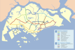
The East Coast Parkway (Abbreviation: ECP) is an expressway that runs along the southeastern coast of Singapore. It is approximately 20 kilometres (12 mi)...
14 KB (1,487 words) - 15:38, 24 March 2024

The Thomson–East Coast Line (TEL) is a high-capacity Mass Rapid Transit (MRT) line in Singapore. Coloured brown on the rail map, it is fully underground...
74 KB (4,360 words) - 14:29, 12 May 2024

East Coast Park is a beach and a park on the southeastern coast of Singapore. It stretches along the south of Marine Parade, Bedok and Tampines. It was...
42 KB (4,762 words) - 09:01, 15 May 2024
Expressway via Johor–Singapore Causeway). The latest expressway completed is the 5 km Marina Coastal Expressway (MCE), which links the East Coast Parkway and Kallang-Paya...
20 KB (1,066 words) - 14:08, 12 December 2023

Bedok South MRT station (category Proposed railway stations in Singapore)
Thomson–East Coast line in Bedok planning area, Singapore. The station will be located next to Temasek Secondary School, at the intersection of Upper East Coast...
6 KB (366 words) - 07:51, 8 May 2024

The North East Line (NEL) is a high-capacity Mass Rapid Transit (MRT) line in Singapore. Operated by SBS Transit, the 20-kilometre (12 mi) line is the...
111 KB (8,972 words) - 06:55, 5 April 2024

West Coast is a subzone located in the town of Clementi, the western part of Singapore. The subzone currently lies in the West Coast GRC. West Coast was...
9 KB (789 words) - 10:29, 15 May 2024

the Mandai Road junction until the northern coast, it was named as Sembawang Road. The name Seletar Road was dropped. In 1959, the Singapore Rural Board...
6 KB (539 words) - 09:04, 12 December 2023

Mass Rapid Transit (MRT) lines in Singapore, the East West Line (EWL), the Downtown Line (DTL) and the Thomson-East Coast Line (TEL). It is currently under...
7 KB (643 words) - 08:53, 21 April 2024

The Electronic Road Pricing (ERP) system is an electronic toll collection scheme adopted in Singapore to manage traffic by way of road pricing, and as...
40 KB (3,396 words) - 15:32, 26 April 2024
West Coast Highway (Chinese: 西海岸大路; Malay: Lebuhraya Pantai Barat; Tamil: மேற்கு கடற்கரை நெடுஞ்சாலை) is a major arterial road in Singapore which links...
11 KB (1,066 words) - 08:29, 12 December 2023
is a geographical region located along the south-eastern coast of the East Region of Singapore. Although its boundaries are not exactly clear, it is widely...
9 KB (1,075 words) - 00:49, 6 September 2023
Roman Catholic Lasallian all-boys' secondary school located along East Coast Road, Singapore. It is more commonly referred to as St Pat's, SPS or St Patrick's...
11 KB (1,276 words) - 14:47, 21 January 2024

(/ˈwʊdləndz/ ) is a planning area and residential town located in the North of Singapore. As of 2019, the town has a population of 254,733. Located approximately...
27 KB (2,586 words) - 03:56, 16 April 2024

the town centre, a shopping complex, West Coast Plaza, serves the residents along West Coast Road. The Singapore Police 'D' Divisional Headquarters is located...
23 KB (2,066 words) - 14:03, 8 April 2024

Joo Chiat Road is a road in Katong and a residential conservation area located in the east coast of Singapore. It has won several architectural and heritage...
13 KB (1,578 words) - 06:09, 6 December 2023
Marine Parade MRT station (category Proposed railway stations in Singapore)
Rapid Transit station on the Thomson–East Coast line in Marine Parade, Singapore. Located underneath Marine Parade Road near the junction of Marine Parade...
9 KB (572 words) - 09:48, 2 May 2024

The East–West Line (EWL) is a high-capacity Mass Rapid Transit (MRT) line operated by SMRT in Singapore, running from Pasir Ris station in the east to...
99 KB (6,528 words) - 07:02, 8 May 2024

Geographically, Singapore comprises its mainland and other islands. The mainland of Singapore measures 50 kilometres (31 mi) from east to west and 27 kilometres...
22 KB (2,613 words) - 19:29, 4 May 2024
Changi (redirect from Changi, East Region, Singapore)
the East Region of Singapore. Sharing borders with Pasir Ris and Tampines to the west, Changi Bay to the southeast, the South China Sea to the east and...
38 KB (4,365 words) - 21:44, 27 April 2024

The North-East Region (Chinese: 東北區) of Singapore is one of the five regions in the country. The region is the most densely populated and has the highest...
35 KB (3,286 words) - 07:15, 27 September 2023

Jurong East is a planning area and residential town situated in the West Region of Singapore. It borders Jurong West and Boon Lay to the west, Clementi...
16 KB (1,037 words) - 11:45, 2 March 2024

operating in South-East Asia to Singapore. Steamships had to frequently bunker and therefore take the route along the South Asian coast line which also preferred...
109 KB (12,350 words) - 02:45, 14 May 2024

Tanjong Katong MRT station (category Proposed railway stations in Singapore)
Thomson-East Coast Line in Marine Parade, Singapore. The station will be built underneath the intersection of Tanjong Katong Road South and Amber Road. Tanjong...
9 KB (600 words) - 03:58, 18 May 2024
Road names in Singapore come under the purview of the Street and Building Names Board of the Urban Redevelopment Authority. In 1967, the Advisory Committee...
33 KB (1,507 words) - 10:30, 3 February 2024

Bukit Merah (redirect from Redhill, Singapore)
and the Singapore River to the north and HarbourFront and Keppel Bay to the south, Kim Seng Road, Outram Road and Cantonment Road to the east and Alexandra...
23 KB (1,703 words) - 03:19, 2 April 2024

of the Central Region of Singapore. It borders Bukit Timah to the north, Tanglin to the northeast, Bukit Merah to the east and southeast, as well as...
25 KB (2,441 words) - 20:18, 11 May 2024

Outram Park MRT station (category Use Singapore English from August 2023)
station in Singapore. The station is on the East–West, North East and Thomson–East Coast lines, and is located near the junction of Outram Road, Eu Tong...
34 KB (2,696 words) - 06:11, 17 May 2024

Marine Parade (redirect from Marine Parade, Singapore)
Region of Singapore. Straddling the tip of the southeastern coast of Pulau Ujong, Marine Parade serves as a buffer between the Central and East regions...
8 KB (509 words) - 13:16, 12 May 2024