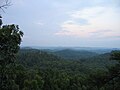
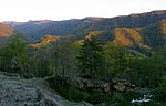
 | The Eastern Kentucky Coalfield is part of the Central Appalachian bituminous coalfield, including all or parts of 30 Kentucky counties and adjoining areas... 35 KB (2,402 words) - 13:17, 14 November 2023 |
 | the ballot. Reagan carried 100 of Kentucky's counties; Mondale carried 19, mostly in the Eastern Kentucky Coalfield. One county–Gallatin County–split... 93 KB (550 words) - 02:54, 13 April 2024 |
 | economic, educational and entertainment hub for the surrounding areas of eastern Kentucky, Virginia and West Virginia. It is home to the University of Pikeville... 26 KB (2,385 words) - 08:54, 3 May 2024 |
 | Black Mountain is the highest mountain peak in the Commonwealth of Kentucky, United States, with a summit elevation of 4,145 feet (1,263 m) above mean... 7 KB (734 words) - 05:55, 25 January 2024 |
 | The converted theater serves as an important venue for the arts in eastern Kentucky and the neighboring sections of Ohio and West Virginia. It is well... 40 KB (3,705 words) - 03:25, 11 May 2024 |
 | Census, down from 784 at the 2010 census. McRoberts is in the Eastern Kentucky Coalfield region. McRoberts is located in northeastern Letcher County at 37°12′30″N... 7 KB (563 words) - 17:05, 20 March 2024 |
 | Kentucky waterways consists of coal that is shipped from both the Eastern and Western Coalfields, about half of which is used locally to power many power plants... 213 KB (19,055 words) - 11:02, 3 May 2024 |
 | Cumberland Gap (category Eastern Kentucky Coalfield) the eastern United States through the long ridge of the Cumberland Mountains, within the Appalachian Mountains and near the tripoint of Kentucky, Virginia... 19 KB (1,851 words) - 11:53, 15 April 2024 |
 | marks the second consecutive election in which no county in the Eastern Kentucky Coalfield voted Democratic. Furthermore, this is the first time since 1948... 89 KB (1,143 words) - 15:27, 24 April 2024 |
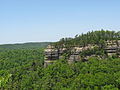 | Red River Gorge (category Eastern Kentucky Coalfield) The Red River Gorge is a canyon system on the Red River in east-central Kentucky, United States. Geologically it is part of the Pottsville Escarpment. The... 18 KB (1,963 words) - 18:44, 1 May 2024 |
 | located in the northeastern part of the U.S. state of Kentucky, in the Eastern Kentucky Coalfield region. As of the 2020 census, the population was 24... 17 KB (1,465 words) - 02:25, 26 April 2024 |
 | the Eastern District of Kentucky (in case citations, E.D. Ky.) is the Federal district court whose jurisdiction comprises approximately the Eastern half... 22 KB (1,006 words) - 03:21, 25 April 2024 |
 | Representatives in 1832. Born near Middlesboro, Kentucky, a small rural mountain town located in the Eastern Kentucky Coalfield, White was a member of the prestigious... 16 KB (1,523 words) - 19:11, 10 May 2024 |
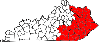
Tennessee (one county each). The 14 counties in Kentucky on the list are located in the Eastern Kentucky Coalfield, a region with an economy formerly dominated... 11 KB (658 words) - 12:46, 30 March 2024 |
coal in what would become Kentucky and used it to heat his camp fire. Although his discovery came in the Eastern Coalfield it would be another 150 years... 32 KB (3,234 words) - 20:30, 14 December 2023 |
| Daniel Boone National Forest (category Eastern Kentucky Coalfield) Forest (originally the Cumberland National Forest) is a national forest in Kentucky. Established in 1937, it includes 708,000 acres (287,000 ha) of federally... 23 KB (2,343 words) - 04:39, 7 October 2023 |
 | in the heart of Appalachia in Southeastern Kentucky, it represents much of the Eastern Kentucky Coalfield. The rural district is the second most impoverished... 50 KB (679 words) - 01:36, 7 May 2024 |
| represents a mixture of the Highland Rim and the western border of the Eastern Kentucky Coalfield. The highest elevation in the county is Limestone Knob (1435 ft)... 28 KB (2,602 words) - 19:05, 23 January 2024 |
Wolfpen, in Mallie, Kentucky, is a historic site which was listed on the National Register of Historic Places in 2014. It is the log house which became... 1 KB (48 words) - 17:15, 22 April 2023 |
Louisville and Frankfort areas 606, which serves eastern Kentucky, including the Eastern Coalfield 859, which serves the Lexington area and Northern Kentucky... 792 bytes (51 words) - 03:03, 25 November 2023 |
 | extends eastward into the Appalachian Plateau (or Eastern Kentucky Coalfield), and northward to Kentucky's Outer Bluegrass region. Thus, the area shows variations... 25 KB (2,173 words) - 18:14, 20 November 2023 |
 | Area code 606 (category Area codes in Kentucky) Maysville. Most of its service area lies within the Kentucky region known as the Eastern Kentucky Coalfield. It runs along the entire length of the state's... 63 KB (471 words) - 07:50, 4 May 2024 |
 | contributing buildings in the core of the historic downtown of Barbourville, Kentucky. The district is roughly bounded by Daniel Boone Dr., Liberty, High, and... 2 KB (106 words) - 18:21, 5 August 2023 |
ambitious record, the album rarely transcends its tale." Eastern Kentucky Coalfield Kentucky in the American Civil War Currin, Grayson Haver (August 19... 7 KB (601 words) - 14:50, 22 January 2024 |
 | The Carnegie Library in Corbin, Kentucky, United States, is a building from 1916. It was listed on the National Register of Historic Places in 1986. It... 2 KB (89 words) - 08:19, 26 December 2022 |
 | Saltpeter Cave (category Eastern Kentucky Coalfield Registered Historic Place stubs) Saltpeter Cave, in Carter Caves State Resort Park near Olive Hill, Kentucky. It was listed on the National Register of Historic Places in 2001. It has... 2 KB (230 words) - 11:13, 13 October 2022 |
 | Pikeville station (redirect from Chesapeake and Ohio Depot (Pikeville, Kentucky)) The Chesapeake and Ohio Passenger Depot in Pikeville, Kentucky was built by the Chesapeake and Ohio Railway in 1923. The station along with a small baggage... 4 KB (229 words) - 16:51, 5 January 2023 |
 | McConnell House, Law Office, and Slave Quarters (category Eastern Kentucky Coalfield Registered Historic Place stubs) The McConnell House, Law Office, and Slave Quarters, near Wurtland, Kentucky, United States, was listed on the National Register of Historic Places in... 2 KB (177 words) - 12:47, 15 March 2024 |
 | The Jackson Post Office in Jackson, Kentucky, at the intersection of Hawk and Broadway, was built in 1916. It was listed on the National Register of Historic... 2 KB (134 words) - 01:15, 23 March 2024 |
 | Western Coal Field (redirect from Western Kentucky coalfields) County Hart County Logan County Todd County Warren County The term Western Coalfield (or Western Coal Field) is used to define the region with Pennsylvanian-age... 5 KB (558 words) - 13:58, 13 March 2024 |