 | El Dorado County (/ˌɛl dəˈrɑːdoʊ/ ), officially the County of El Dorado, is a county located in the U.S. state of California. As of the 2020 census, the... 61 KB (3,425 words) - 17:12, 29 April 2024 |
 | El Dorado Hills (El Dorado, Spanish for "The Golden") is an unincorporated town and census-designated place in El Dorado County, California. Located in... 23 KB (2,344 words) - 19:09, 27 October 2023 |
 | 84778°W / 38.68278; -120.84778 El Dorado (Spanish for "The Golden") is an unincorporated community in El Dorado County, California. It is located 4 miles (6... 5 KB (391 words) - 21:03, 25 December 2023 |
 | Geographic Names Information System: Strawberry, El Dorado County, California Durham, David L. (1998). California's Geographic Names: A Gazetteer of Historic... 4 KB (194 words) - 06:21, 29 July 2023 |
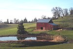
 | census-designated place in El Dorado County, California, US. It is approximately 36 miles (58 km) northeast of Sacramento, California. Coloma is most noted... 16 KB (1,292 words) - 11:24, 4 January 2024 |
County, California El Dorado AVA, California wine region in El Dorado County Eldorado Glacier, Washington El Dorado Hills, California Eldorado Mountain,... 7 KB (920 words) - 03:36, 24 April 2024 |
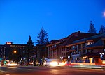
 | Diggings, Dry Diggings, and Hangtown) is a city in and the county seat of El Dorado County, California. The population was 10,747 as of the 2020 census, up... 34 KB (3,124 words) - 21:05, 23 February 2024 |
 | The El Dorado Fire was a wildfire that burned 22,744 acres (9,204 ha; 35.538 sq mi; 92.04 km2) in San Bernardino and Riverside counties of California from... 44 KB (3,133 words) - 05:00, 24 April 2024 |
Lewisville, and Louisville) is an unincorporated community in El Dorado County, California. It is located 4 miles (6.4 km) west of Georgetown, at an elevation... 3 KB (205 words) - 01:35, 30 January 2024 |
 | El Dorado (Spanish: [el doˈɾaðo], English: /ˌɛl dəˈrɑːdoʊ/; Spanish for "the golden") is commonly associated with the legend of a gold city, kingdom,... 66 KB (8,405 words) - 15:43, 10 May 2024 |
 | The El Dorado County Fair is held in Placerville, California, every Father's Day weekend. The annual event opens on the third Thursday in June and concludes... 7 KB (595 words) - 05:12, 29 March 2024 |
 | public high school in El Dorado Hills, California, United States, 20 miles (32 km) east of Sacramento. It is part of the El Dorado Union High School District... 12 KB (1,204 words) - 07:03, 27 April 2024 |
Rescue, formerly Green Valley, El Dorado County, California, is an unincorporated community in El Dorado County, California. It is located north-northwest... 5 KB (386 words) - 02:03, 9 September 2023 |
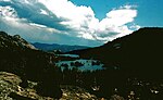
 | Lake is a lake in the backcountry of the Desolation Wilderness in the Sierra Nevada of El Dorado County, California. List of lakes in California v t e... 2 KB (29 words) - 20:29, 1 September 2023 |
 | Diamond Spring and Diamond) is a census-designated place (CDP) in El Dorado County, California, United States. It is part of the Sacramento–Arden-Arcade–Roseville... 8 KB (783 words) - 04:57, 10 July 2023 |
School District Buckeye Union School District Camino Union School District El Dorado Union High School District Gold Oak Union School District Gold Trail Union... 58 KB (5,117 words) - 03:41, 9 May 2024 |
Frenchtown (formerly, French Creek) is an unincorporated community in El Dorado County, California. It is located on French Creek 2 miles (3.2 km) south-southeast... 2 KB (116 words) - 16:00, 31 December 2023 |
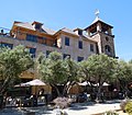
 | South Lake Tahoe is the most populous city in El Dorado County, California, United States, in the Sierra Nevada mountains. The city's population was 21... 26 KB (2,267 words) - 15:47, 10 May 2024 |
 | Cameron Park is a census-designated place (CDP) in El Dorado County, California, United States and is part of the Greater Sacramento Area. The population... 19 KB (1,924 words) - 09:50, 16 March 2024 |
Lakes are a pair of lakes on the west side of Mount Price in El Dorado County, California, in the Desolation Wilderness. The lakes are known for their... 1 KB (65 words) - 20:47, 2 November 2023 |
 | reservoir located in El Dorado County, eastern California, United States. Echo Lake is in the Sierra Nevada, and within the El Dorado National Forest. The... 3 KB (145 words) - 09:18, 29 August 2023 |
properties and districts listed on the California Historical Landmark listing in El Dorado County, California. Click the "Map of all coordinates" link... 11 KB (108 words) - 21:13, 13 May 2024 |
 | Area code 530 (category El Dorado County, California) Nevada. It comprises all or sections of the following counties: Alpine, Butte, Colusa, El Dorado, Glenn, Humboldt, Lassen, Modoc, Mono, Nevada, Placer... 17 KB (772 words) - 02:32, 9 April 2024 |
 | Wilderness in El Dorado County, California. Media related to Silver Peak (El Dorado County, California) at Wikimedia Commons "Silver Peak, California". Peakbagger... 2 KB (89 words) - 11:11, 5 April 2023 |
(formerly, New town) is a small unincorporated community in El Dorado County, California, United States. It is located 2.25 miles (3.6 km) south of Camino... 3 KB (168 words) - 15:38, 27 July 2023 |
82333; -120.80944 Spanish Flat is an unincorporated community in El Dorado County, California. It is located 4 miles (6 km) north of Chili Bar, at an elevation... 2 KB (121 words) - 08:36, 15 January 2024 |
 | crossing into Mariposa County. State Route 49 then continues northward through the counties of Tuolumne, Calaveras, Amador, El Dorado, Placer, Nevada, Yuba... 36 KB (2,930 words) - 12:41, 26 April 2024 |
Dogtown, California may refer to: Dogtown, El Dorado County, California, a former settlement and mining camp Dogtown, Marin County, California, an unincorporated... 1 KB (150 words) - 07:23, 3 January 2024 |
 | Cosumnes River (redirect from Camp Creek (El Dorado County, California)) above Michigan Bar define the El Dorado/Amador County line; below this point, the river flows into southern Sacramento County. The Cosumnes flows west through... 15 KB (1,398 words) - 23:12, 24 December 2023 |
Mountain Long Valley, California, former name of Greenwood, El Dorado County, California This disambiguation page lists articles about distinct geographical... 245 bytes (65 words) - 02:11, 24 March 2024 |