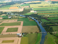
 | The Eramosa River is a river in Wellington County in southwestern Ontario which rises near Erin, Ontario, and flows southwest through the city of Guelph... 23 KB (2,722 words) - 20:22, 23 March 2023 |
 | Guelph/Eramosa (/ˈɡwɛlfˈɛrəˈmɒsə/) is a township located in Wellington County, in midwestern Ontario, Canada. It partly encircles the city of Guelph,... 15 KB (1,251 words) - 20:36, 21 April 2024 |
 | The Eramosa River Trail is a 4.1 km (2.5 mi) urban walking trail that runs alongside the Eramosa River in Guelph, Ontario, Canada, stretching from the... 6 KB (665 words) - 20:52, 28 October 2023 |
 | north of Waterloo. The Eramosa River joins the Speed River in Guelph. The Speed River joins the Grand in Cambridge. The Nith River joins the Grand in Paris... 33 KB (3,736 words) - 18:21, 28 March 2024 |
 | where it is joined by the Eramosa River, then through the towns of Hespeler and Preston, finally uniting with the Grand River in north-west Cambridge.... 7 KB (726 words) - 05:24, 7 July 2023 |
 | of the Speed River and the Eramosa River, which have numerous tributaries. The Speed River enters from the north and the Eramosa River from the east;... 166 KB (13,753 words) - 18:53, 15 April 2024 |
 | 44°36′N 81°06′W / 44.6°N 81.1°W / 44.6; -81.1 The Eramosa Member is a Silurian stratigraphic unit of the Lockport Formation exposed along the Niagara... 8 KB (853 words) - 13:18, 13 October 2023 |
Interest in Stoney Creek, Ontario Eramosa marble, a building stone obtained from the Eramosa Eramosa River, a river in Wellington County, Ontario This... 500 bytes (98 words) - 17:00, 23 August 2023 |
 | This is the list of rivers which are in and flow through Ontario. The watershed list includes tributaries as well. Dee River, flows between Three Mile... 34 KB (53 words) - 19:04, 8 January 2024 |
analysis of a stalagmite growing from a cave in Puerto Princesa Subterranean River National Park, Palawan, the Philippines, found that the onset of the Younger... 113 KB (12,577 words) - 03:24, 21 April 2024 |
 | Louis, Missouri, and then followed the present course of the Missouri River up to the northern slopes of the Cypress Hills, beyond which it merged with... 14 KB (1,672 words) - 16:37, 1 March 2024 |
 | Driftless Area (section Rivers) Driftless area in Minnesota, due to the steep bluffs and cliffs around the river valleys. The western half is known as the Rochester Plateau, which is flatter... 62 KB (6,948 words) - 14:06, 16 March 2024 |
 | of the glaciation, as is the course of the Ohio River, which largely supplanted the prior Teays River. With the assistance of several very broad glacial... 48 KB (5,348 words) - 08:24, 8 April 2024 |
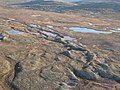
 | Rock (glacial erratic), Alberta Cypress Hills (Canada), Saskatchewan Eramosa River, Ontario Eskers Provincial Park, British Columbia Foothills Erratics... 7 KB (901 words) - 21:10, 13 March 2024 |
 | flow, but force them into the lowest possible points such as valleys or river beds, which may deviate from the direct path of the glacier. This process... 13 KB (1,452 words) - 21:36, 26 September 2023 |
 | meltwaters. The old Teays River drainage system was radically altered and largely reshaped into the Ohio River drainage system. Other rivers were dammed and diverted... 83 KB (10,132 words) - 19:53, 1 April 2024 |
 | River Thames frost fair was in 1608 and the last in 1814. Changes to the bridges and the addition of the Thames Embankment have affected the river's flow... 149 KB (17,564 words) - 08:13, 19 April 2024 |
 | Northern Peninsula of Newfoundland, most of Quebec north of the St. Lawrence River, much of Ontario including northern sections of the Ontario Peninsula, the... 21 KB (2,235 words) - 02:11, 25 April 2024 |
 | undisturbed kame features. They are Minnitaki Kames Provincial Park and Bonheur River Kame Provincial Park. Drumlin Esker Glacial Kame culture Glacial landforms... 6 KB (623 words) - 21:28, 26 September 2023 |
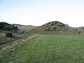
| the city of Guelph, this conservation area is on both sides of the Eramosa River and is a central location within Southern Ontario. The nearby Highway... 9 KB (941 words) - 00:56, 22 October 2019 |
 | America. This glaciation radically altered the geography north of the Ohio River, including in time the creation of the Great Lakes. At the height of the... 16 KB (1,491 words) - 09:14, 7 March 2024 |
 | sediment, or vegetation. If the kettle is fed by surface or underground rivers or streams, it becomes a kettle lake. If the kettle receives its water from... 12 KB (1,188 words) - 15:49, 19 April 2024 |
 | 2018). "Viable Nematodes from Late Pleistocene Permafrost of the Kolyma River Lowland". Doklady Biological Sciences. 480 (1): 100–102. doi:10.1134/S0012496618030079... 45 KB (4,791 words) - 05:25, 9 April 2024 |
 | a confluence where the other branch carries an unfrozen river. The glacier blocks the river, which backs up into a proglacial lake, which eventually... 11 KB (1,151 words) - 19:38, 7 August 2023 |
 | narrow belt for about 600 kilometres (370 mi) from Alberta's Athabasca River Valley to the southwest of the province. White Rock, British Columbia gets... 30 KB (3,378 words) - 19:39, 5 January 2024 |
once located include the walking trails along the south bank of the Eramosa River, the Smith Property loop in Puslinch and the Halton County Radial Railway... 31 KB (3,054 words) - 22:21, 10 March 2024 |
 | redeposited as drift or till. Much of this drift was dumped into old preglacial river valleys, while some of it was heaped into belts of hills (terminal moraines)... 19 KB (2,563 words) - 21:50, 24 May 2023 |
 | Lake Agassiz (category Lakes of the Mississippi River) through the Traverse Gap into Glacial River Warren (parent to the Minnesota River, a tributary of the Mississippi River), east through Lake Kelvin (modern... 40 KB (4,286 words) - 15:33, 28 March 2024 |
 | develop during the LGM, in particular in south-facing slopes. In the Hex River Mountains, in the Western Cape, block streams and terraces found near the... 71 KB (7,838 words) - 06:28, 27 April 2024 |
 | cooler than today. The hippopotamus was distributed as far north as the rivers Rhine and Thames. A cooling event similar to but not exactly mirroring the... 35 KB (3,839 words) - 03:58, 18 March 2024 |