
River Esk (Scottish Gaelic: Easg), also known as the Border Esk[citation needed], is a river that rises in the Scottish region of Dumfries and Galloway before...
4 KB (596 words) - 10:35, 1 May 2024
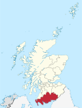
Dumfries and Galloway (Scots: Dumfries an Gallowa; Scottish Gaelic: Dùn Phrìs is Gall-Ghaidhealaibh) is one of the 32 unitary council areas of Scotland...
47 KB (3,514 words) - 12:57, 4 April 2024
Gretna (Scottish Gaelic: Greatna) is a town in Dumfries and Galloway, Scotland, originally part of the historic county of Dumfriesshire. It is located...
9 KB (1,189 words) - 07:41, 20 March 2024

Map of places in Dumfries and Galloway compiled from this list This List of places in Dumfries and Galloway is a list of links for any town, village, hamlet...
7 KB (468 words) - 15:46, 24 November 2023

and Eskdale is a committee area in Dumfries and Galloway, Scotland. It covers the areas of Annandale and Eskdale, the straths of the River Annan and the...
7 KB (680 words) - 04:26, 2 December 2023
National Park and flows into the Irish Sea at Ravenglass River Esk (Solway Firth), a river that rises in the Scottish region of Dumfries and Galloway before...
417 bytes (100 words) - 10:47, 1 May 2024
the Border Esk River Esk (Solway Firth), in Dumfries and Galloway and along the border with England, also known as the Border Esk River Esk, Lothian, which...
1 KB (195 words) - 09:33, 1 May 2024
Canonbie (category Villages in Dumfries and Galloway)
within the local authority area of Dumfries and Galloway in Scotland, 6 miles (10 kilometres) south of Langholm and 2 miles (3 kilometres) north of the...
9 KB (863 words) - 06:41, 2 May 2024

Langholm (category Towns in Dumfries and Galloway)
Toon", is a burgh in Dumfries and Galloway, southern Scotland. Langholm lies between four hills in the valley of the River Esk in the Southern Uplands...
18 KB (1,967 words) - 13:34, 10 April 2024
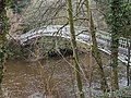
Duchess Bridge (category Category A listed buildings in Dumfries and Galloway)
The Duchess Bridge is a cast iron footbridge over the River Esk in Dumfries and Galloway, Scotland. It was built for Charles Montagu-Scott, 4th Duke of...
8 KB (872 words) - 17:08, 15 February 2024
Errochty (Perth and Kinross) (reservoir) Loch Ericht (Perth and Kinross) (reservoir) Erncrogo Loch (Dumfries and Galloway) Loch Esk (Glen Clova) Loch...
91 KB (9,179 words) - 11:02, 20 May 2024

Ness) Esk, North Esk, South Esk River Esk, Dumfries and Galloway ('Border Esk'), River Esk, Lothian (Lothian); River North Esk; River North Esk (Lothian);...
42 KB (4,521 words) - 13:13, 13 March 2024

River Sark (category Rivers of Dumfries and Galloway)
2016. "Why Flee to Gretna Green?". Gretna Green. Gretna Green, Dumfries and Galloway. Retrieved 18 August 2016. "Debatable Land". University of Portsmouth...
3 KB (354 words) - 23:53, 13 April 2022

The parish is bordered to the west and north by Dumfries and Galloway, Scotland; to the north east by Nicholforest, and to the south by Arthuret. The area...
4 KB (279 words) - 09:22, 25 February 2022

Dumfriesshire (redirect from Dumfries & Annandale)
Since 1975, the area of the historic county has formed part of the Dumfries and Galloway council area for local government purposes. The coastline measures...
34 KB (4,132 words) - 16:26, 7 May 2024
Castle O'er Forest (category Dumfries and Galloway)
Forest is a forest south of Eskdalemuir, Dumfries and Galloway, in southern Scotland. It is bisected by the River Esk. Eskdalemuir Forest adjoins it to the...
733 bytes (59 words) - 11:08, 20 January 2024

Kirtle Water (category Rivers of Dumfries and Galloway)
The Kirtle Water is a river in Dumfries and Galloway in southern Scotland. It rises on the southern slopes of Haggy Hill where its headwaters are impounded...
1 KB (145 words) - 12:58, 11 April 2022
Langholm in Dumfries and Galloway, the largest population centre being Canonbie. The lands included the baronies of Kirkandrews, Bryntallone and Morton. They...
10 KB (1,060 words) - 12:10, 2 February 2024

Ewesdale (category Landforms of Dumfries and Galloway)
Ewesdale is a glen and former lordship in Dumfries and Galloway, Scotland. The Ewes Water runs through the valley from its source at Mosspaul until it...
1 KB (102 words) - 22:07, 24 March 2024

Eskdalemuir Forest (category Dumfries and Galloway)
Eskdalemuir Forest is a forest north of Eskdalemuir, Dumfries and Galloway, in southern Scotland. It was created as a private enterprise by the Economic...
1 KB (107 words) - 17:39, 7 January 2021

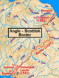
Anglo-Scottish border (redirect from Border between England and Scotland)
the modern council areas of Dumfries and Galloway and the Scottish Borders, and parts of the English counties of Cumbria and Northumberland. It is a hilly...
31 KB (3,181 words) - 14:52, 9 May 2024
Eskdale (Scotland) (redirect from Eskdale, Dumfries and Galloway)
Eisgeadal, IPA:[ˈeʃkʲət̪əɫ̪]) is a glen and former lordship in the county of Dumfriesshire, Scotland. The River Esk flows through Eskdale to its estuary...
2 KB (133 words) - 21:24, 12 October 2023

Bentpath (category Villages in Dumfries and Galloway)
village between Eskdalemuir and Langholm in Dumfries and Galloway, Scotland. It is located on the River Esk and has a church and a library. Westerkirk library...
1 KB (87 words) - 03:24, 23 April 2022
Southern Uplands (category Geography of Dumfries and Galloway)
populations of sea trout, salmon and Eurasian otters. The two unitary authorities of Dumfries and Galloway in the west and the Scottish Borders in the east...
23 KB (2,523 words) - 17:46, 6 January 2024

Riddings Junction Viaduct (category Category A listed buildings in Dumfries and Galloway)
Kirkandrews-on-Esk in Cumbria to the north bank near Rowanburn, in the parish of Canonbie, Dumfries and Galloway. It opened on 18 March 1864 and closed, with...
4 KB (350 words) - 21:36, 27 April 2023
Glencartholm (category Dumfries and Galloway)
Glencartholm is a location in Dumfries and Galloway, southern Scotland, along the River Esk. The Glencartholm Volcanic Beds contain a Palaeozoic (specifically...
3 KB (297 words) - 21:56, 22 October 2022
Dumfries and Galloway, Scotland Eskdale, North Yorkshire, England Eskdale (UK Parliament constituency), Cumberland, England, former constituency EskDale...
661 bytes (92 words) - 11:48, 13 September 2021
Eskdalemuir (category Villages in Dumfries and Galloway)
parish and small village in Dumfries and Galloway, Scotland, with a population of 265. It is around 10 miles (16 km) north-west of Langholm and 10 miles...
10 KB (571 words) - 01:15, 8 April 2024
may refer to: Kirkandrews, Dumfries and Galloway, hamlet in Dumfries and Galloway, Scotland Kirkandrews-on-Eden, village and former civil parish in Beaumont...
411 bytes (80 words) - 05:52, 20 April 2022

Eskdalemuir Observatory (category Category B listed buildings in Dumfries and Galloway)
environmental observatory located near Eskdalemuir, Dumfries and Galloway, Scotland. Along with Lerwick and Hartland, Eskdalemuir is one of three permanent...
6 KB (657 words) - 15:43, 9 February 2024