 | The European Terrestrial Reference System 1989 (ETRS89) is an ECEF (Earth-Centered, Earth-Fixed) geodetic Cartesian reference frame, in which the Eurasian... 6 KB (585 words) - 18:43, 20 March 2024 |
| datum Degree Confluence Project Earth Gravitational Model European Terrestrial Reference System 1989 Geo (microformat) – for marking up WGS 84 coordinates... 24 KB (2,809 words) - 05:56, 18 March 2024 |
 | Satellite Systems (GNSS) and geoid use. It will use the following four frames of reference, each representing a tectonic plate: North American Terrestrial Reference... 6 KB (555 words) - 16:13, 16 April 2024 |
| '\tan \xi '\tanh \eta '}}\right).} European Terrestrial Reference System 1989 (ETRS89) Military grid reference system, a variant of UTM designed to simplify... 17 KB (2,610 words) - 23:05, 29 February 2024 |
of EUREF and a backbone in the maintenance of the European Terrestrial Reference System 1989. European Combined Geodetic Network (ECGN) is a research project... 6 KB (566 words) - 02:32, 20 July 2023 |
| A spatial reference system (SRS) or coordinate reference system (CRS) is a framework used to precisely measure locations on the surface of Earth as coordinates... 15 KB (1,546 words) - 22:10, 9 April 2024 |
| (HEPOS) project, is GPS based and is compatible with European Terrestrial Reference System 1989 (ETRS89). HTRS07 is currently used for the cadastral surveys... 7 KB (827 words) - 10:07, 15 December 2023 |
| The Geodetic Reference System 1980 (GRS80) is a geodetic reference system consisting of a global reference ellipsoid and a normal gravity model. Geodesy... 7 KB (945 words) - 05:26, 28 September 2023 |
| The Military Grid Reference System (MGRS) is the geocoordinate standard used by NATO militaries for locating points on Earth. The MGRS is derived from... 15 KB (2,133 words) - 06:55, 13 February 2024 |
 | versions, the ideal International Terrestrial Reference System (ITRS) and its realization, the International Terrestrial Reference Frame (ITRF). The most important... 13 KB (767 words) - 19:40, 26 March 2024 |
Satellite Systems (GNSS) stations as the primary data source for the implementation of a uniform reference frame. European Terrestrial Reference System 1989 "AFREF... 819 bytes (66 words) - 21:01, 2 April 2021 |
| The Global Area Reference System (GARS) is a standardized geospatial reference system developed by the National Geospatial-Intelligence Agency (NGA) for... 3 KB (470 words) - 12:54, 13 December 2022 |
 | 2021. Snay, Richard A.; Soler, Tomás (December 1999). "Modern Terrestrial Reference Systems (Part 1)" (PDF). Professional Surveyor. "Polar motion". Archived... 9 KB (904 words) - 13:39, 7 January 2024 |
| Geodetic datum (redirect from Geodetic reference system) geodetic system (also: geodetic reference datum, geodetic reference system, or geodetic reference frame) is a global datum reference or reference frame for... 29 KB (3,073 words) - 16:06, 31 December 2023 |
| EPSG Geodetic Parameter Dataset (category Geographic coordinate systems) spatial reference systems, Earth ellipsoids, coordinate transformations and related units of measurement, originated by a member of the European Petroleum... 5 KB (448 words) - 13:19, 16 January 2024 |
| appropriate mapping of the spherical coordinate system onto that ellipsoid, called a terrestrial reference system or geodetic datum. Datums may be global, meaning... 21 KB (2,380 words) - 18:12, 4 April 2024 |
| Ordnance Survey National Grid (redirect from British national grid reference system) Ireland (since 2001). European-wide agencies also use UTM when mapping locations, or may use the Military Grid Reference System (MGRS), or variants of... 19 KB (2,130 words) - 10:22, 14 April 2024 |
 | coordinate system – also called a projected coordinate reference system, planar coordinate system, or grid reference system – is a type of spatial reference system... 21 KB (2,802 words) - 02:18, 12 April 2024 |
| Geoid (redirect from Reference geoid) Deflection of the vertical Geodetic datum Geopotential International Terrestrial Reference Frame Physical geodesy Planetary geoid Areoid (Mars' geoid) Selenoid... 26 KB (3,056 words) - 23:24, 18 April 2024 |
| Earth ellipsoid (redirect from Reference ellipsoid) geographic applications, a geodesic reference ellipsoid is the mathematical model used as foundation by spatial reference system or geodetic datum definitions... 19 KB (2,379 words) - 23:35, 14 April 2024 |
| The Irish grid reference system is a system of geographic grid references used for paper mapping in Ireland (both Northern Ireland and the Republic of... 6 KB (657 words) - 12:25, 6 April 2022 |
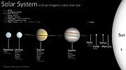 | terrestrial planets (Mercury, Venus, Earth and Mars); two gas giants (Jupiter and Saturn); and two ice giants (Uranus and Neptune). All terrestrial planets... 204 KB (20,492 words) - 18:47, 23 April 2024 |
| to three Wide-area Master Stations (WMS) using a terrestrial communications network. The reference stations also monitor signals from WAAS geostationary... 42 KB (4,012 words) - 20:23, 8 April 2024 |
 | North American Datum (category Articles needing additional references from September 2010) and the North American Datum of 1983 (NAD 83). Both are geodetic reference systems based on slightly different assumptions and measurements. Vertical... 13 KB (1,613 words) - 06:32, 16 April 2024 |
Television in Russia (redirect from Digital terrestrial television in Russia) stations). By 1989 an improved version of the Moskva system, called Moskva Global'naya, (or Moscow Global) was introduced. The system included a few... 32 KB (2,139 words) - 04:36, 22 April 2024 |
Pokémon Go. Reference frames: realization and densification of the terrestrial reference frames in the framework of Global Geodetic Observing System. Co-location... 177 KB (18,448 words) - 19:11, 19 April 2024 |
 | Moon (redirect from Terrestrial moon) second highest among all Solar System moons, after Jupiter's moon Io. The body of the Moon is differentiated and terrestrial, with no significant hydrosphere... 253 KB (24,434 words) - 17:41, 19 April 2024 |
| point on the ellipsoid surface. This concept aids the interpretation of terrestrial and planetary radio occultation refraction measurements and in some navigation... 23 KB (2,821 words) - 15:15, 24 April 2024 |
| Geo URI scheme (category Geographic information systems) identifies a physical location in a two- or three-dimensional coordinate reference system in a compact, simple, human-readable, and protocol-independent way... 14 KB (1,850 words) - 08:23, 8 December 2023 |
 | Geodesy (category Wikipedia articles incorporating a citation from the 1911 Encyclopaedia Britannica with Wikisource reference) networks, applying space geodesy and terrestrial geodetic techniques, and relying on datums and coordinate systems. The job titles are geodesist and geodetic... 37 KB (4,184 words) - 21:12, 12 April 2024 |