English A geographic map of the United Kingdom showing which parties won each constituency determination method or standard: SHA-1...
(1,248 × 1,039 (5.36 MB)) - 18:07, 28 April 2023

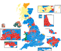
Description2017UKElectionMap votes.svg English: Results of the 2017 general election in the United Kingdom. The voting distribution per constituency....
(1,020 × 996 (7.53 MB)) - 18:07, 28 April 2023

Author Brythones SVG development InfoField The SVG code is valid. This map was created with Inkscape, or with something else. This map uses embedded...
(809 × 716 (950 KB)) - 18:07, 28 April 2023

file was derived from: 2017UKElectionMap.svg Author derivative map: Furfur, based on Election results 2019: Analysis in maps and charts, BBC News, 13...
(1,229 × 779 (9.65 MB)) - 10:18, 25 October 2020

file was derived from: 2017UKElectionMap.svg Author derivative map: Furfur, based on Election results 2019: Analysis in maps and charts, BBC News, 13...
(950 × 779 (9.65 MB)) - 19:15, 6 March 2022

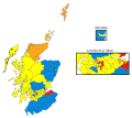
2019 GE.svg English: Map of constituencies contested by the Brexit Party at the 2019 UK General Election. Made using File:2017UKElectionMap.svg Date 11...
(1,248 × 1,039 (5.35 MB)) - 02:36, 21 December 2023
from Brythones SVG development InfoField The SVG code is valid. This map was created with Inkscape, or with something else. This map uses embedded...
(809 × 716 (950 KB)) - 03:26, 28 August 2023

File:UK General Election 2017-19 result changes.gif (category Maps of the 2019 UK general election (by constituency))
the 2017 and 2019 UK general elections. Uses File:2019UKElectionMap.svg and File:2017UKElectionMap.svg Date 9 January 2020 Source Own work Author RaviC...
(916 × 761 (267 KB)) - 15:10, 3 February 2021

File:Jun2017MPsEngland.png (category Maps of the 2017 UK general election (by constituency))
org/wikipedia/commons/c/ce/2017UKElectionMap.svg Author RaviC - removed residual colour code from 2010 election from 2015 base map, Brythones, recoloured...
(1,142 × 707 (3.09 MB)) - 06:19, 12 September 2024

File:Results of the 2019 General Election in the UK v2.png (category UK general election maps)
png English: Based off of https://commons.wikimedia.org/wiki/File:2017UKElectionMap.svg Date 12 December 2019 Source Own work Author ThatGamingSheep...
(5,080 × 4,980 (3.72 MB)) - 16:40, 20 July 2024

es-december-2017-generalised-clipped-boundaries-in-uk/explore1 (with alteration) Map layout: File:2017UKElectionMap.svg (with modification) Author 沁水湾...
(512 × 426 (16.07 MB)) - 16:05, 19 July 2024