
license: English M23 offensive (2022–present) French Résurgence du M23 Russian Наступление «Движения 23 марта» (с 2022) Spanish Ofensiva del M23 (2022-presente)...
(3,000 × 5,000 (2.03 MB)) - 05:12, 3 April 2025

under the following license: English Map of the conflict in Kivu: the Congolese state and its allies against the M23 and its allies. French Carte du conflit...
(512 × 671 (399 KB)) - 13:08, 17 May 2025

guideline. https://svgtranslate.toolforge.org/File:Syrian_Civil_War_map_(ISW-CTP).svg Nu Validator This file is licensed under the Creative Commons Attribution...
(922 × 762 (4.06 MB)) - 10:07, 9 May 2025

Commons Attribution-Share Alike 4.0 truetrue English Syrian Civil War map. This map cites https://syria.liveuamap.com/ Do not modify it without citing any...
(922 × 762 (3.47 MB)) - 05:00, 10 February 2025

holder of this work, hereby publish it under the following license: English Map of Al-Qaeda in the Islamic Maghreb (AQIM) activities French Carte de l'activité...
(468 × 344 (132 KB)) - 20:30, 6 March 2025
Selected maps are included in the Wikimedia Atlas of Syria. See also : Category:Conflicts by country I, the copyright holder of this work, hereby publish...
(3,360 × 3,436 (821 KB)) - 10:05, 9 March 2025
same source. Please ensure that overwrites comply with the guideline. The SVG code is valid. This vector image was created with Inkscape. I, the copyright...
(1,241 × 1,264 (775 KB)) - 21:33, 23 March 2025

BY-SA 4.0 Creative Commons Attribution-Share Alike 4.0 truetrue English Map showing the DRC-Rwanda conflict (2022-present). author name string: Rr016...
(1,240 × 1,181 (978 KB)) - 22:42, 23 March 2025

BY-SA 4.0 Creative Commons Attribution-Share Alike 4.0 truetrue English Map of the Myanmar civil war (2021–present) by township Russian Территориальный...
(1,052 × 1,169 (3.34 MB)) - 00:18, 24 December 2024

image is a derivative work of the following images: File:Libyan_war_final.svg licensed with Cc-by-sa-3.0 2011-10-21T13:35:26Z Rafy 1100x1100 (101850 Bytes)...
(1,100 × 1,100 (100 KB)) - 14:51, 21 October 2024

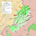
Description2013 Hama Offensive.svg English: Map showing the course of the 2013 Hama Offensive. Syrian Government control post-offensive Opposition control...
(3,493 × 1,755 (4.43 MB)) - 03:17, 8 October 2024

org/licenses/by-sa/4.0CC BY-SA 4.0 Creative Commons Attribution-Share Alike 4.0 truetrue English Potential map of the Current situation in Somalia....
(512 × 650 (187 KB)) - 18:17, 3 March 2025

DescriptionAleppo Offensives 2015.svg English: Map of the course of the 2015 Aleppo Offensives during the Syrian Civil War. Syrian Government control...
(2,326 × 2,566 (4.24 MB)) - 18:14, 5 January 2025

ensure that overwrites comply with the guideline. English Yemeni civil war map Spanish Mapa de la Guerra Civil Yemení (actualizada en septiembre de 2023)...
(1,625 × 1,061 (1.3 MB)) - 07:49, 26 April 2025

Attribution-Share Alike 3.0 truetrue You may select the license of your choice. English Map of ongoing conflicts around the world Urdu دنیا بھر میں جاری تنازعات کا نقشہ...
(512 × 289 (1.61 MB)) - 09:20, 18 April 2025

Selected maps are included in the Wikimedia Atlas of Libya. See also : Category:Maps of countries I, the copyright holder of this work, hereby publish...
(1,033 × 991 (805 KB)) - 10:50, 16 June 2024

Sub-national-wide Maps: Cameroon (Bakassi conflict) Cameroon (Anglophone Crisis) DR Congo (in East) (Kivu conflict) DR Congo (in East) (Kivu - M23 Offensive) Gaza−Israel...
(1,139 × 577 (377 KB)) - 00:04, 20 December 2024

BY-SA 4.0 Creative Commons Attribution-Share Alike 4.0 truetrue English Map of South Sudanese Civil War Arabic خارطة النفوذ في الحرب الأهلية في جنوب...
(1,561 × 1,133 (1.71 MB)) - 14:14, 21 November 2024

File:Syrian civil war.png (category Georeferenced maps in Wikimaps Warper)
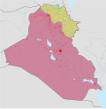
Selected maps are included in the Wikimedia Atlas of Syria. See also : Category:Conflicts by country I, the copyright holder of this work, hereby publish...
(2,502 × 2,107 (1,020 KB)) - 14:46, 9 February 2025

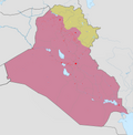
Selected maps are included in the Wikimedia Atlas of Egypt. See also : Category:Conflicts by country I, the copyright holder of this work, hereby publish...
(499 × 796 (246 KB)) - 06:38, 1 May 2025

Sub-national-wide Maps: Cameroon (Bakassi conflict) Cameroon (Anglophone Crisis) DR Congo (in East) (Kivu conflict) DR Congo (in East) (Kivu - M23 Offensive) Gaza−Israel...
(978 × 824 (3.24 MB)) - 14:51, 21 October 2024
Sub-national-wide Maps: Cameroon (Bakassi conflict) Cameroon (Anglophone Crisis) DR Congo (in East) (Kivu conflict) DR Congo (in East) (Kivu - M23 Offensive) Gaza−Israel...
(2,430 × 2,463 (3.8 MB)) - 21:33, 23 March 2025
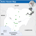
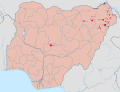
it because there had not been any images explaining the insurgency while maps showing the islamic state in iraq and sham exists. 1[dead link] - Gwoza,...
(254 × 254 (412 KB)) - 06:44, 1 May 2025
Sub-national-wide Maps: Cameroon (Bakassi conflict) Cameroon (Anglophone Crisis) DR Congo (in East) (Kivu conflict) DR Congo (in East) (Kivu - M23 Offensive) Gaza−Israel...
(954 × 734 (399 KB)) - 06:44, 1 May 2025

Sub-national-wide Maps: Cameroon (Bakassi conflict) Cameroon (Anglophone Crisis) DR Congo (in East) (Kivu conflict) DR Congo (in East) (Kivu - M23 Offensive) Gaza−Israel...
(883 × 900 (4.91 MB)) - 18:29, 17 September 2024

Sub-national-wide Maps: Cameroon (Bakassi conflict) Cameroon (Anglophone Crisis) DR Congo (in East) (Kivu conflict) DR Congo (in East) (Kivu - M23 Offensive) Gaza−Israel...
(1,880 × 1,351 (1.63 MB)) - 21:33, 23 March 2025

Sub-national-wide Maps: Cameroon (Bakassi conflict) Cameroon (Anglophone Crisis) DR Congo (in East) (Kivu conflict) DR Congo (in East) (Kivu - M23 Offensive) Gaza−Israel...
(1,150 × 1,095 (977 KB)) - 12:26, 7 April 2025

Sub-national-wide Maps: Cameroon (Bakassi conflict) Cameroon (Anglophone Crisis) DR Congo (in East) (Kivu conflict) DR Congo (in East) (Kivu - M23 Offensive) Gaza−Israel...
(1,579 × 677 (765 KB)) - 12:05, 19 September 2020

Sub-national-wide Maps: Cameroon (Bakassi conflict) Cameroon (Anglophone Crisis) DR Congo (in East) (Kivu conflict) DR Congo (in East) (Kivu - M23 Offensive) Gaza−Israel...
(1,485 × 971 (7.38 MB)) - 21:33, 23 March 2025
Sub-national-wide Maps: Cameroon (Bakassi conflict) Cameroon (Anglophone Crisis) DR Congo (in East) (Kivu conflict) DR Congo (in East) (Kivu - M23 Offensive) Gaza−Israel...
(992 × 1,142 (263 KB)) - 14:44, 9 February 2025