choice. This image is a derivative work of the following images: File:Rajendra_map_new.png licensed with Cc-by-sa-3.0-migrated-with-disclaimers, GFDL-en,...
(466 × 333 (220 KB)) - 03:54, 24 May 2024
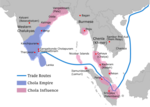
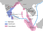
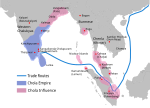
629×442× (215021 bytes) Map showing th extent of the [[Chola empire]] during [[Rajendra Chola I]] (c. 1030 CE) English Chola Kingdom map Tamil சோழ நாடு வரைபடம்...
(466 × 333 (84 KB)) - 01:15, 12 January 2024

DescriptionRajendra map new de.svg Deutsch: Karte des Chola-Reiches während der Regierungszeit Rajendra I. (c. 1030) English: Map showing the extent of...
(931 × 667 (161 KB)) - 03:36, 10 November 2021

DescriptionRajendra map new-pt.svg Português: Império Srivijaia Date 21 March 2011 Source This file was derived from: Rajendra map new.svg: Author Gregors...
(465 × 333 (204 KB)) - 12:27, 27 October 2020

DescriptionRajendra map new-es.svg English: Map showing the extent of the Chola empire during Rajendra Chola I (c. 1030 CE) per http://cw.routledge...
(465 × 333 (373 KB)) - 04:46, 10 November 2021
BY-SA 3.0 Creative Commons Attribution-Share Alike 3.0 truetrue English Map showing the extent of the Chola empire during 10 – 11th century determination...
(466 × 333 (200 KB)) - 22:23, 3 March 2024

https://commons.wikimedia.org/wiki/File:Rajendra_map_new.svg and https://en.wikipedia.org/wiki/Talk:Chola_dynasty#Maps by Verosaurus on 27 December 2022. Pegu...
(650 × 464 (504 KB)) - 21:49, 27 December 2022

Descriptionஇராசேந்திரச் சோழன்.svg தமிழ்: இராசேந்திரச் சோழன் Date 28 July 2022 Source Rajendra_map_new.png and *Rajendra map new.svg Author Rajendra_map_new.png: The original...
(512 × 366 (327 KB)) - 10:25, 4 August 2022

File:LocationChola empire sm.png (category Superseded by SVG)
This file has been superseded by Rajendra map new.svg. It is recommended to use the other file. Please note that deleting superseded images requires...
(270 × 143 (7 KB)) - 20:30, 7 July 2021