
DescriptionEU-Germany.svg Italiano: (Verde) Germania. (Verde chiaro) Unione europea (UE). (Grigio) Europa. (Grigio chiaro) Zone circostanti. Vedi...
(2,045 × 1,720 (7.33 MB)) - 10:47, 6 June 2023

|Author=[[User:HernauMan|HernauMan]] |Date=2009-05-15 |Permiss EU-United Kingdom.svg licensed with Cc-by-sa-3.0, GFDL 2009-10-23T15:07:42Z NuclearVacuum...
(590 × 603 (670 KB)) - 06:48, 16 May 2023

circundante. Vea también: Category:SVG locator maps of countries in European Union (gray and green scheme) Category:SVG locator maps of countries of Europe...
(2,045 × 1,720 (7.32 MB)) - 12:10, 25 April 2023

pdf archive copy at the Wayback Machine other Version (german): File:Energielabel de.svg Incorporates Image:Flag_of_Europe.png by User:SKopp English...
(354 × 784 (25 KB)) - 12:26, 23 November 2023

English EU Single Market German EU-Binnenmarkt Polish Europejski Obszar Gospodarczy...
(1,300 × 1,300 (441 KB)) - 06:05, 2 March 2023

SVG map of Europe. Borders of nation states.}} {{no|1=SVG-kart over Europa. Nasjonstatlige grenser.}} |Source=[[:Image:Location Spain EU Europe 1.svg]]...
(145 × 193 (311 KB)) - 12:58, 7 February 2022

The 1st is derived from .File:EU-Germany.svg. by en:User:NuclearVacuum and the second is form .File:BlankMap-World-2009-2011-28-02-2011-01-03.png. by Commons...
(2,842 × 1,246 (148 KB)) - 08:21, 19 May 2023
English German Logo der .eu Top-Level-Domain...
(1,024 × 590 (13 KB)) - 16:46, 25 November 2022

English German Struktuformel von Eu(hfc)3 author name string: Speedpera Wikimedia username: Speedpera...
(512 × 286 (7 KB)) - 17:54, 25 June 2022

|Quelle = Bandlogo von [http://necronomicon.eu necronomicon.eu]: [http://necronomicon.eu/pic/logo_800.jpg], abgerufen am 03.04.2010 |Urheber = SVG-Da...
(775 × 130 (4 KB)) - 18:31, 7 March 2021

Union (EU) on a globe German Die Europäische Union (EU) auf einem Globus French L'Union européenne (UE) sur un globe Upper Sorbian Europska unija (EU) na...
(541 × 541 (152 KB)) - 11:07, 14 April 2024

SVG map of Europe. Borders of nation states.}} {{no|1=SVG-kart over Europa. Nasjonstatlige grenser.}} |Source=[[:Image:Location Spain EU Europe 1.svg]]...
(2,045 × 1,720 (731 KB)) - 11:45, 31 May 2023

under the following license: English Support for EU membership in Ukraine (%) German Unterstützung für EU-Mitgliedschaft (in %) author name string: Jo1971...
(1,653 × 993 (17 KB)) - 01:14, 18 January 2024

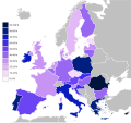
Switzerland (not in the EU, 64% native German speakers) added separately. Data for Switzerland as of 2006 according to linguadult.ch[1]: German is spoken as a...
(1,218 × 1,245 (55 KB)) - 12:18, 11 September 2020
easy coloring. |Source=Image based on [[Image:Europe_countries.svg|]] by [[User:Ti File:EU_belief_in_god.png licensed with Cc-by-sa-3.0-migrated, GFDL...
(480 × 450 (584 KB)) - 09:57, 12 November 2022

license: English Modal split of freight transport, EU, 2021 German Aufteilung der Güterverkehrsleistung in der EU 2021 author name string: A11w1ss3nd Wikimedia...
(650 × 400 (12 KB)) - 10:56, 24 January 2024

diagram-en.svg has 40 embedded translations. ca (Catalan) cs (Czech) da (Danish) de (German) en (English) es (Spanish) eo (Esperanto) eu (Basque) fr...
(850 × 500 (293 KB)) - 08:06, 19 November 2023
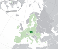
Commons Attribution-Share Alike 3.0 truetrue You may select the license of your choice. English EU and the Czech Republic Czech Poloha Česka na mapě Evropy....
(2,045 × 1,720 (7.33 MB)) - 12:10, 25 April 2023

original. https://creativecommons.org/licenses/by-sa/3.0CC BY-SA 3.0 Creative Commons Attribution-Share Alike 3.0 truetrue English Polish EU and Croatia...
(2,045 × 1,720 (7.33 MB)) - 08:55, 2 February 2024

|other_versions=Image:Elektro Uploaded with derivativeFX English German In der EU verpflichtendes Kennzeichnungssymbol für die getrennte Entsorgung von...
(420 × 597 (2 KB)) - 21:36, 3 December 2023

21:52 Ladyt 855×578× (103453 bytes) {{Information |Beschreibung = Anteil des EU-Farmlandes in verschiedenen Ländern als Kuchendiagramm |Quelle = selbst vektorisiert...
(855 × 578 (101 KB)) - 06:04, 11 January 2024

DescriptionLocator map EU in Germany.svg Deutsch: Lage von Kreis Euskirchen in Nordrhein-Westfalen, Deutschland English: Locator map of Kreis Euskirchen...
(1,075 × 1,273 (637 KB)) - 23:33, 30 October 2020

choice. English EU and Poland French (V. foncé) Pologne. (V. clair) Reste UE. (G foncé) Reste Europe. (G clair) Reg. environs. German (Dunkelgrün) Polen...
(2,045 × 1,720 (7.33 MB)) - 03:39, 26 May 2023

[[European Union|EU]], [[EFTA]] and candidate countries, 2007 German Karte der Vier Motoren für Europa / NUTS 2 Regionen der [[Europäische Union|EU]]- und [[EFTA]]-Länder...
(850 × 600 (2.14 MB)) - 14:12, 2 August 2023

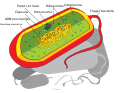
cell- en.svg has 36 embedded translations. as (Assamese) be (Belarusian) bg (Bulgarian) bn (Bangla) ca (Catalan) cs (Czech) da (Danish) de (German) el (Greek)...
(910 × 1,020 (95 KB)) - 22:17, 29 April 2024

File:Knowledge_of_German_EU_map.png licensed with PD-self 2009-05-23T22:36:14Z HernauMan 1218x1245 (56214 Bytes) {{Information |Description={{en|1=Knowledge of German language...
(590 × 603 (671 KB)) - 08:32, 3 March 2024

DescriptionRoyal Coat of Arms of Greece.svg English: Coat of arms of the Kingdom of Greece in 1936–1973 Royal Coat of Arms of Greece under the Glücksburg...
(512 × 602 (2.1 MB)) - 16:09, 27 November 2023
bn (Bangla) ca (Catalan) cs (Czech) da (Danish) de (German) el (Greek) en (English) es (Spanish) eu (Basque) fi (Finnish) fr (French) gl (Galician) gu...
(573 × 444 (297 KB)) - 20:59, 30 August 2023

population pyramid.svg has 30 embedded translations. ar (Arabic) bg (Bulgarian) ca (Catalan) cs (Czech) de (German) es (Spanish) eu (Basque) fi (Finnish)...
(800 × 600 (38 KB)) - 11:35, 29 July 2023
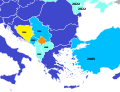
image is a derivative work of the following images: File:Blank_map_of_Europe.svg licensed with Cc-by-sa-2.5 2012-02-21T16:27:27Z Alphathon 680x520 (614699...
(680 × 520 (601 KB)) - 16:04, 26 June 2022