
DescriptionEcuador location map.svg Deutsch: Positionskarte von Ecuador Quadratische Plattkarte. Geographische Begrenzung der Karte: N: 1.7° N S: 5.3°...
(1,535 × 1,654 (1.03 MB)) - 23:57, 2 June 2023

This image is a derivative work of the following images: File:Ecuador_location_map.svg licensed with GFDL-1.2 2008-12-09T21:09:07Z NordNordWest 1536x1654...
(1,536 × 1,654 (394 KB)) - 21:02, 9 October 2020

This image is a derivative work of the following images: File:Ecuador_location_map.svg licensed with GFDL-1.2 2008-12-09T21:09:07Z NordNordWest 1536x1654...
(1,536 × 1,654 (416 KB)) - 00:57, 2 November 2020

This image is a derivative work of the following images: File:Ecuador_location_map.svg licensed with GFDL-1.2 2008-12-09T21:09:07Z NordNordWest 1536x1654...
(598 × 640 (31 KB)) - 15:09, 15 September 2020
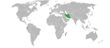
svg licensed with Cc-by-sa-2.5 2008-05-24T14:23:34Z Marmelad 940x415 (1752532 Bytes) {{Information |Description=Autogenerated locator map for bilateral...
(940 × 415 (1.15 MB)) - 18:04, 8 August 2021

Location map for the Ecuador. Originally created for English Wikipedia by Vardion. English...
(250 × 115 (5 KB)) - 02:50, 7 June 2023

der Karte:}} {{en|Location map [[w:en:Hesse|Hesse]], Germany. Geographic limits of the map:}} * N: 51 Lower Saxony location map.svg licensed with Cc-by-sa-3...
(928 × 1,116 (1.22 MB)) - 09:08, 23 March 2022

This SVG map is part of a locator map series applying the widespread location map scheme. Please see root category to browse for more. FDFBEA → Marked...
(512 × 386 (1.4 MB)) - 23:54, 1 January 2024
This SVG map is part of a locator map series applying the widespread location map scheme. Please see root category to browse for more. FDFBEA → Marked...
(512 × 448 (1.8 MB)) - 02:45, 22 May 2024
This SVG map is part of a locator map series applying the widespread location map scheme. Please see root category to browse for more. FDFBEA → Marked...
(512 × 209 (1.77 MB)) - 22:47, 7 March 2024

This SVG map is part of a locator map series applying the widespread location map scheme. Please see root category to browse for more. FDFBEA → Marked...
(512 × 386 (556 KB)) - 23:56, 1 January 2024

{{Imagecredit|credit=Peter Fitzgerald|captureDate=20 January 2010|location=Ecuador|source=[[:Image:Ecuador regions map.svg]]|c (Import from wikitravel.org/shared) English...
(2,352 × 3,008 (1.57 MB)) - 14:11, 8 May 2023
This SVG map is part of a locator map series applying the widespread location map scheme. Please see root category to browse for more. FDFBEA → Marked...
(512 × 684 (2.88 MB)) - 00:00, 2 January 2024

DescriptionEcuador relief location map.svg Ecuador physical map, parameters equal to File:Ecuador location map.svg Date 14 March 2014 Source Own work...
(851 × 917 (3.76 MB)) - 06:42, 27 July 2023

Fitzgerald|captureDate=20 January 2010|location=Ecuador|source=[[:Image:Ecuador regions map.svg]]|caption=Ecuador (Import from wikitravel.org/shared) English...
(973 × 1,225 (532 KB)) - 14:11, 8 May 2023

This SVG map is part of a locator map series applying the widespread location map scheme. Please see root category to browse for more. FDFBEA → Marked...
(512 × 386 (1.4 MB)) - 23:54, 1 January 2024
This SVG map is part of a locator map series applying the widespread location map scheme. Please see root category to browse for more. FDFBEA → Marked...
(512 × 448 (1.8 MB)) - 00:00, 2 January 2024
This SVG map is part of a locator map series applying the widespread location map scheme. Please see root category to browse for more. FDFBEA → Marked...
(512 × 343 (4.36 MB)) - 23:55, 1 January 2024
This SVG map is part of a locator map series applying the widespread location map scheme. Please see root category to browse for more. FDFBEA → Marked...
(512 × 386 (556 KB)) - 23:56, 1 January 2024

This SVG map is part of a locator map series applying the widespread location map scheme. Please see root category to browse for more. FDFBEA → Marked...
(512 × 684 (2.88 MB)) - 00:00, 2 January 2024

This SVG map is part of a locator map series applying the widespread location map scheme. Please see root category to browse for more. FDFBEA → Marked...
(512 × 209 (1.77 MB)) - 22:48, 7 March 2024

under the following license: English This is a world map showing the location and shape of Ecuador. author name string: Sanjay Rao Wikimedia username:...
(1,000 × 1,000 (84 KB)) - 23:52, 3 September 2023

under the following license: English This is a world map showing the location and shape of Ecuador. author name string: Sanjay Rao Wikimedia username:...
(1,000 × 1,000 (192 KB)) - 23:52, 3 September 2023

This SVG map is part of a locator map series applying the widespread location map scheme. Please see root category to browse for more. FDFBEA → Marked...
(512 × 343 (4.36 MB)) - 23:55, 1 January 2024

This SVG map is part of a locator map series applying the widespread location map scheme. Please see root category to browse for more. English...
(512 × 383 (1.08 MB)) - 21:05, 24 June 2023

This SVG map is part of a locator map series applying the widespread location map scheme. Please see root category to browse for more. English...
(512 × 626 (1.81 MB)) - 16:11, 24 February 2023

This SVG map is part of a locator map series applying the widespread location map scheme. Please see root category to browse for more. English...
(512 × 626 (1.81 MB)) - 16:15, 24 February 2023

This SVG map is part of a locator map series applying the widespread location map scheme. Please see root category to browse for more. English...
(512 × 626 (1.81 MB)) - 19:00, 25 February 2023

This SVG map is part of a locator map series applying the widespread location map scheme. Please see root category to browse for more. English...
(512 × 626 (1.81 MB)) - 19:01, 25 February 2023

This SVG map is part of a locator map series applying the widespread location map scheme. Please see root category to browse for more. English...
(512 × 383 (1.08 MB)) - 21:06, 24 June 2023