 | n:User:Cacahuate|Cacahuate]]|captureDate=|location=Asia|source=Created by user|caption=Map of Asia|description=A ma (Import from wikitravel.org/shared)... (974 × 797 (313 KB)) - 00:41, 2 January 2024 |
 | works of this file: 1581 Bunting clover leaf map-ar.png Derivative works of this file: خارطة العالم تتوسطها مدينة القدس.jpg English Stylized world map in... (4,441 × 3,496 (14.36 MB)) - 22:22, 30 September 2023 |
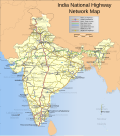 | detailed map of all disputed regions in South Asia, see Image:India disputed areas map.svg The borders of the state of Meghalaya, Assam and Arunachal Pradesh... (1,639 × 1,852 (1.11 MB)) - 11:09, 9 February 2024 |
 | Köppen Map.png Asia Köppen Map.png Australia-Oceania Köppen Map.png Europe Köppen Map.png North America Köppen Map.png Russia Köppen Map.png South America... (2,749 × 2,168 (1.49 MB)) - 21:11, 26 September 2023 |
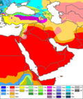 | Köppen Map.png Asia Köppen Map.png Australia-Oceania Köppen Map.png Europe Köppen Map.png North America Köppen Map.png Russia Köppen Map.png South America... (990 × 1,182 (511 KB)) - 09:12, 13 May 2021 |
 | Köppen Map.png Asia Köppen Map.png Australia-Oceania Köppen Map.png Europe Köppen Map.png North America Köppen Map.png Russia Köppen Map.png South America... (545 × 537 (60 KB)) - 15:29, 23 March 2024 |
 | Köppen Map.png Asia Köppen Map.png Australia-Oceania Köppen Map.png Europe Köppen Map.png North America Köppen Map.png Russia Köppen Map.png South America... (4,231 × 2,804 (1.05 MB)) - 05:58, 4 January 2022 |
 | Köppen Map.png Asia Köppen Map.png Australia-Oceania Köppen Map.png Europe Köppen Map.png North America Köppen Map.png Russia Köppen Map.png South America... (1,500 × 1,816 (834 KB)) - 21:37, 6 September 2023 |
 | Köppen Map.png Asia Köppen Map.png Australia-Oceania Köppen Map.png Europe Köppen Map.png North America Köppen Map.png Russia Köppen Map.png South America... (1,885 × 1,200 (831 KB)) - 09:12, 13 May 2021 |
 | English Map of Central Asia in 1903, including Russian Empire territory in Central Asia.... (2,548 × 1,804 (7.49 MB)) - 09:10, 20 June 2022 |
 | translated by Peter Fitzgerald|captureDate=|location=Asia|source=[[:Image:Map of Asia.png (Import from wikitravel.org/shared) 2008-03-07 03:50 (WT-shared)... (1,400 × 1,116 (354 KB)) - 16:22, 12 August 2023 |
 | Köppen Map.png Asia Köppen Map.png Australia-Oceania Köppen Map.png Europe Köppen Map.png North America Köppen Map.png Russia Köppen Map.png South America... (1,200 × 1,821 (642 KB)) - 12:49, 17 June 2023 |
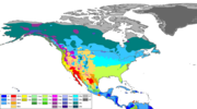 | Köppen Map.png Asia Köppen Map.png Australia-Oceania Köppen Map.png Europe Köppen Map.png North America Köppen Map.png Russia Köppen Map.png South America... (2,958 × 1,650 (1.19 MB)) - 09:12, 13 May 2021 |
 | Köppen Map.png Asia Köppen Map.png Australia-Oceania Köppen Map.png Europe Köppen Map.png North America Köppen Map.png Russia Köppen Map.png South America... (1,612 × 1,373 (398 KB)) - 04:12, 3 October 2023 |
 | Description: Second World War Asia 1937-1942, map German Source: Own map, based on the maps of the University of Texas Libraries Author: San Jose, 26 April... (1,298 × 998 (137 KB)) - 07:54, 19 March 2024 |
 | 本地语言的南亚行政区划 South Asia in local languages... Derivative works of this file: Languages of South Asia.png South asia local lang1.PNG English... (725 × 684 (126 KB)) - 08:00, 27 September 2023 |
 | I, the copyright holder of this work, hereby publish it under the following license: English Life expectancy map for Asia Russian Карта ожидаемой продолжительности... (3,885 × 3,088 (2 MB)) - 16:02, 13 September 2023 |
 | I, the copyright holder of this work, hereby publish it under the following license: English Life expectancy map for Asia Russian Карта ожидаемой продолжительности... (3,885 × 3,088 (2.03 MB)) - 18:51, 13 September 2023 |
 | I, the copyright holder of this work, hereby publish it under the following license: English Life expectancy map for Asia Russian Карта ожидаемой продолжительности... (3,885 × 3,088 (2 MB)) - 15:51, 13 September 2023 |
 | Köppen Map.png Asia Köppen Map.png Australia-Oceania Köppen Map.png Europe Köppen Map.png North America Köppen Map.png Russia Köppen Map.png South America... (1,860 × 575 (151 KB)) - 09:12, 13 May 2021 |
 | found at [[: File:Europe Asia transcontinental.png]]. Since the latter is a derived version of this one, a copy of the flawed map should be kept around for... (1,596 × 1,043 (86 KB)) - 10:00, 25 April 2023 |
 | Köppen Map.png Asia Köppen Map.png Australia-Oceania Köppen Map.png Europe Köppen Map.png North America Köppen Map.png Russia Köppen Map.png South America... (1,388 × 866 (269 KB)) - 01:34, 17 February 2024 |
 | University of Texas Libraries Autor: San Jose, 26. April 2005 A French version is available: Image:Second world war asia 1943-1945 map fr-1.png English... (1,298 × 998 (193 KB)) - 06:33, 13 February 2023 |
 | Creative Commons Attribution-Share Alike 4.0 truetrue English Central Asia Map author name string: 최성녕 Wikimedia username: 최성녕 URL: https://commons.wikimedia... (773 × 520 (61 KB)) - 13:10, 6 January 2024 |
 | Map for use with Asia stub templates. Based on Image:LocationAsia.png (30.11.2006) English... (58 × 48 (3 KB)) - 07:57, 6 June 2023 |
 | Make you ASIA map I, the copyright holder of this work, hereby publish it under the following license: This file is licensed under the Creative Commons... (1,100 × 885 (71 KB)) - 22:17, 22 October 2022 |
 | 3.0 truetrue This image is a derivative work of the following images: File:States of South Asia new.png licensed with Cc-by-sa-3.0-migrated, GFDL-GMT... (798 × 752 (130 KB)) - 19:24, 7 November 2020 |
 | holder of this work, hereby publish it under the following license: This image is a derivative work of the following images: File:Asia_Map_Plain.PNG licensed... (508 × 397 (13 KB)) - 00:20, 31 October 2020 |
 | huate]]|captureDate=August 6, 2007|location=Central Asia|source=created by uploader|caption=Map of (Import from wikitravel.org/shared) 2008-03-18 23:32... (1,239 × 941 (217 KB)) - 16:35, 12 August 2023 |
 | Blank weather map of East Asia and around. Map based Image:East Asia map blank.png. English... (1,200 × 800 (43 KB)) - 04:38, 25 September 2020 |