 | DescriptionMap of Tokyo Ja.svg English: Map of Tokyo Prefecture, Japan. 日本語: ja:東京都区画図 Date 18 April 2008, 16:28 (UTC) Source Original file: Own work Data:... (847 × 635 (74 KB)) - 11:32, 12 February 2023 |
 | {{Information |Description=Map of cities within Western part of Tokyo Metropolis |Source=*[[:ja:ファイル:包括自治体区画図 13000.svg|包括自治体区画図 13000.svg]] |Date=17 November... (793 × 750 (155 KB)) - 15:36, 17 March 2024 |
 | English Map in Japanese language of Special wards of Tokyo Japanese 東京特別区(東京23区)の地図 (日本語)... (550 × 500 (25 KB)) - 12:56, 20 February 2024 |
 | (102 KB) ASDFGH ({{Information |Description=Map of wards of Special wards of Tokyo |Source=*包括自治体区画図 13000.svg |Date=6 May 2009 |Author=*derivative work:... (791 × 796 (139 KB)) - 12:56, 20 February 2024 |
 | 768 Tokyo Metro Fukutoshin Line 300 528 104 117 1024 768 Tōkyū Tōyoko Line 300 645 104 102 1024 768 Minatomirai Line 798 58 139 82 1024 768 Tokyo Metro... (1,024 × 768 (2.57 MB)) - 06:16, 24 October 2020 |
 | (WT-shared) Tatata[dead link] 1512×1189 (73163 bytes) {{Imagecredit |credit=[[:ja:User:Tatata]] |captureDate=2007-03-16 |location=Urayasu |source=based on [http://commons... (1,497 × 1,190 (71 KB)) - 13:08, 30 July 2023 |
 | I, the copyright holder of this work, hereby publish it under the following licenses: This file is licensed under the Creative Commons Attribution-Share... (800 × 610 (54 KB)) - 12:27, 20 December 2021 |
 | Map of Tokyo Ja.svg... (512 × 320 (345 KB)) - 19:46, 10 May 2023 |
 | DescriptionMiyake in Tokyo Prefecture Ja.svg English: Location of Miyake Village in Tokyo Prefecture 日本語: ja:東京都三宅村位置図 Date 12 September 2007 Source Original... (800 × 610 (45 KB)) - 04:54, 18 March 2024 |
 | DescriptionKozushima in Tokyo Prefecture Ja.svg English: Location of Kozushima Village in Tokyo Prefecture 日本語: ja:東京都神津島村位置図 Date 12 September 2007 Source... (800 × 610 (45 KB)) - 08:59, 18 March 2024 |
 | DescriptionOgasawara in Tokyo Prefecture Ja.svg English: Location of Ogasawara Village in Tokyo Prefecture 日本語: ja:東京都小笠原村位置図 Date 12 September 2007 Source... (800 × 610 (46 KB)) - 07:37, 17 March 2024 |
 | DescriptionToshima in Tokyo Prefecture Ja.svg English: Location of Toshima Village in Tokyo Prefecture 日本語: ja:東京都利島村位置図 Date 12 September 2007 Source... (800 × 610 (45 KB)) - 23:01, 16 March 2024 |
 | DescriptionMikurajima in Tokyo Prefecture Ja.svg English: Location of Mikurajima Village in Tokyo Prefecture 日本語: ja:東京都御蔵島村位置図 Date 12 September 2007... (800 × 610 (45 KB)) - 05:04, 18 March 2024 |
 | DescriptionOshima in Tokyo Prefecture Ja.svg English: Location of Oshima Town in Tokyo Prefecture 日本語: ja:東京都大島町位置図 Date 12 September 2007 Source Original... (800 × 610 (45 KB)) - 06:54, 17 March 2024 |
 | DescriptionNiijima in Tokyo Prefecture Ja.svg English: Location of Niijima Village in Tokyo Prefecture 日本語: ja:東京都新島村位置図 Date 12 September 2007 Source... (800 × 610 (45 KB)) - 08:00, 17 March 2024 |
 | select the license of your choice. This image is a derivative work of the following images: File:Construction_of_the_Yamanote_Line_ja.svg licensed with Cc-by-3... (392 × 383 (29 KB)) - 17:32, 12 April 2024 |
 | Teruo ed. Zenkoku Akusento Jiten (Accent Dictionary throughout Japan), Tokyo: Tōkyōdō, the 4th edition, 1962 (first printed in 1960). 大野晋、柴田武編 『岩波講座... (2,030 × 1,905 (464 KB)) - 17:04, 29 April 2023 |
 | 768 Tokyo Metro Fukutoshin Line 300 528 104 117 1024 768 Tōkyū Tōyoko Line 300 645 104 102 1024 768 Minatomirai Line 798 58 139 82 1024 768 Tokyo Metro... (1,024 × 768 (2.59 MB)) - 12:56, 21 October 2020 |
 | (WT-shared) Tatata[dead link] 744×1052 (356769 bytes) {{Imagecredit |credit=[[:ja:User:Tatata]] |captureDate=2007-03-16 |location=Urayasu |source=based on [http://commons... (744 × 1,052 (578 KB)) - 13:08, 30 July 2023 |
 | DescriptionHigashiyamato in Tokyo Prefecture Ja.png 中文(香港):Higashiyamato in Tokyo Prefecture, Japan Date 27 December 2023 Source File:Map of Tokyo Ja.svg and File:基礎自治体位置図... (6,000 × 4,575 (1.99 MB)) - 11:55, 18 March 2024 |
 | I, the copyright holder of this work, hereby publish it under the following license: This file is licensed under the Creative Commons Attribution-Share... (1,500 × 937 (11.66 MB)) - 08:33, 16 October 2022 |
 | English: Expantion of Haneda, Tokyo International Airport. 日本語: 東京国際空港(羽田)拡張エリア 参考資料/Refferences: [1][2] I, the copyright holder of this work, hereby publish... (562 × 448 (817 KB)) - 13:59, 14 January 2023 |
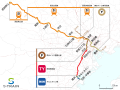
 | The route image in SVG file: information referred http://www.new-skyliner.jp/ This image is a derivative work of the following images: File:Narita_New_Rapid_Line_plan... (809 × 481 (388 KB)) - 16:41, 18 October 2020 |
 | The original description page was here. All following user names refer to ja.wikipedia. 2007-03-29 11:32 Lincun 512×256× (22721 bytes) {{人口統計画像情報|東京都|武蔵野市}}... (512 × 256 (22 KB)) - 15:11, 21 May 2022 |
 | The original description page was here. All following user names refer to ja.wikipedia. 2007-03-28 12:19 Lincun 512×256× (22661 bytes) {{人口統計画像情報|東京都|中野区}}... (512 × 256 (22 KB)) - 14:41, 21 May 2022 |
 | DescriptionKatsushika-ku in Tokyo Prefecture Ja.svg English: Location of Katsushika ward, Tokyo, Japan 日本語: ja:東京都葛飾区位置図 Date 9 September 2007 Source Original... (800 × 610 (41 KB)) - 10:13, 18 March 2024 |
 | The original description page was here. All following user names refer to ja.wikipedia. 2007-03-29 11:28 Lincun 512×256× (22522 bytes) {{人口統計画像情報|東京都|八王子市}}... (512 × 256 (22 KB)) - 14:41, 21 May 2022 |
 | DescriptionSumida-ku in Tokyo Prefecture Ja.svg English: Location of Sumida ward, Tokyo, Japan 日本語: ja:東京都墨田区位置図 Date 8 September 2007 Source Original... (800 × 610 (39 KB)) - 00:23, 17 March 2024 |
 | DescriptionNerima-ku in Tokyo Prefecture Ja.svg English: Location of Nerima ward, Tokyo, Japan 日本語: ja:東京都練馬区位置図 Date 9 September 2007 Source Original... (800 × 610 (41 KB)) - 08:29, 17 March 2024 |
 | DescriptionTokyo Metropolitan Expressway map-ja.svg English: Map of the Tokyo Metropolitan Expressway network (red) and connecting expressways (green)... (6,048 × 8,688 (144 KB)) - 15:46, 23 October 2021 |