
The world, c. 1000 BC. hunter-gatherers nomadic pastoralists simple farming societies complex farming societies/chiefdoms state societies uninhabited...
(4,500 × 2,234 (401 KB)) - 02:41, 3 April 2024

1407×2138× (157671 bytes) Crop of [http://commons.wikimedia.org/wiki/File:World_1000_BCE.png File:World 1000 BCE.png] English determination method: SHA-1...
(1,407 × 2,138 (135 KB)) - 07:00, 6 August 2023

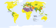
The world, c. 200 BCE. hunter-gatherers nomadic pastoralists simple farming societies complex farming societies/chiefdoms state societies ...
(4,000 × 1,986 (789 KB)) - 19:41, 6 April 2024

The world, c. 500 BC; detail showing Vietnam. Cropped version of original map, which is located at Image:World 500 BCE.png. hunter-gatherers nomadic...
(336 × 408 (14 KB)) - 20:22, 6 September 2020

The world, 2000 BCE. Vector version hunter-gatherers nomadic pastoralists simple farming societies complex farming societies/chiefdoms state...
(4,000 × 1,986 (1 MB)) - 01:09, 29 September 2023

File:East-Hem 500bc.jpg (category Maps of the world showing history)
2: Information on other tribes derives from Briangott's map of the World 500 BCE.png and/or Wikipedia articles. . . . . (Ainu, Final Jomon Culture, Korean...
(3,240 × 1,903 (1.41 MB)) - 16:55, 4 April 2024

File:East-Hem 100bc.jpg (category Maps of the world showing history)
Wikimedia's map of the World in 100 BCE.PNG by User:Javierfv1212. Parthian Empire borders are derived from Persia borders are shown in the WorldHistoryMaps.com...
(3,240 × 1,903 (737 KB)) - 13:47, 22 January 2024
English The world in 400 BC French Le monde en 400 avant JC Spanish El mundo en El ano 400 a.C. German Die welt im Jahr 400 v. Chr URL: https://commons...
(4,700 × 2,392 (2.03 MB)) - 19:27, 21 February 2024

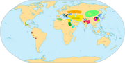
The world, c. 500 BC. hunter-gatherers nomadic pastoralists simple farming societies complex farming societies/chiefdoms state societies uninhabited...
(4,000 × 1,986 (974 KB)) - 02:46, 3 April 2024

Hellenized states and empires Haywood, John, et al. The Cassell Atlas of World History. Andromeda Oxford Ltd., 1997. p. 2.01. I, the copyright holder of...
(4,500 × 2,234 (467 KB)) - 02:46, 3 April 2024

File:East-Hem 1000bc.jpg (category Maps of the world showing history)
us References for information contained in this map: 1. Some info derive from the map of the World 1000 BCE, created by User:Briangotts.. 2. Zhou (China)...
(3,240 × 1,903 (1.43 MB)) - 13:47, 22 January 2024

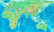
File:East-Hem 200bc.jpg (category Maps of the world showing history)
derived from: 1. Wikimedia's map of the Qin empire 210 BCE.png, and from 2. The DK Atlas of World History, 2000 Edition; map of The Han Empire; (Page 260)...
(3,240 × 1,903 (2.23 MB)) - 13:49, 22 January 2024
Red outline indicates areas of bronze working, c. 2000 BCE. English Map of societies, 2000 BCE. Colour coded by cultural stage. Includes simple farming...
(4,500 × 2,234 (847 KB)) - 16:47, 16 March 2024

File:East-Hem 050bc.jpg (category Maps of the world showing history)
map of Korea_001.png made by Wikipedia User:Historiographer. 3. Some information also derive from Wikimedia's map of the World_in_50_BCE, created by User:Javierfv1212...
(3,240 × 1,903 (722 KB)) - 13:46, 22 January 2024

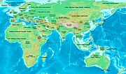
File:East-Hem 400bc.jpg (category Maps of the world showing history)
References for information contained in this map: 1. Some information is derived from Wikipedia's World Map 400 BCE, created by User:Javierfv1212. 2. Zhou...
(3,240 × 1,903 (725 KB)) - 13:50, 22 January 2024

Español: Europa en el 450. Map of Europe in 450 AD, based on free map of europe Image:BlankMap-Europe.png. Many of the border lines are approximations...
(800 × 580 (145 KB)) - 05:52, 18 February 2024
File:East-Hem 1300bc.jpg (category Maps of the world showing history)
contained in this map: 1. The DK Atlas of World History, 2000 Edition; map of The World in 1250 BCE, (Pages 26-27) was used for much of the information in this...
(3,240 × 1,903 (1.42 MB)) - 07:42, 23 January 2024
File:East-Hem 323bc.jpg (category Maps of the world showing history)
derived from The DK Atlas of World History, 2000 Edition; Pg. 178; Map of Italy in 240 BCE (also shows Roman borders in 300 BCE). II - Asian Information:...
(3,240 × 1,903 (712 KB)) - 13:49, 22 January 2024

Commons Attribution 4.0 truetrue English Indo-Iranian cultures from 1500 - 1000 BCE author name string: Kjansen86 Wikimedia username: Kjansen86 URL: https://commons...
(2,330 × 1,382 (4.15 MB)) - 05:26, 21 April 2024

File:East-Hem 001ad.jpg (category Maps of the world showing history)
in this map. b - WorldHistoryMaps.com map of the Countries of the World 1/1/36 bce archive copy at the Wayback Machine provides some borders for India...
(3,240 × 1,903 (709 KB)) - 13:46, 22 January 2024
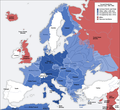
92 927 13 13 1090 1000 Given its strategic importance, Gibraltar should be included as well. English German This map represents Europe in 1941-1942...
(1,090 × 1,000 (216 KB)) - 12:40, 20 April 2024
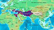
File:Alexander-Empire 323bc.jpg (category Maps of the world showing history)
derived from The DK Atlas of World History, 2000 Edition; Pg. 178; Map of Italy in 240 BCE (also shows Roman borders in 300 BCE). II - Asian Information:...
(2,321 × 1,288 (933 KB)) - 12:20, 22 January 2024

File:East-Hem 300ad.jpg (category Maps of the world showing history)
300 AD. Srivijaya borders are derived from Wikimedia's map of the World_in_300_CE.PNG (see above, #2 under Primary Sources) and the Wikipedia article about...
(3,240 × 1,903 (739 KB)) - 13:49, 22 January 2024

File:East-Hem 050ad.jpg (category Maps of the world showing history)
World in 1 CE, (Pages 42-43) was used for information on several Asian borders in this map. b - Korean borders derive from this map of Korea_001.png made...
(3,240 × 1,903 (722 KB)) - 13:46, 22 January 2024

File:Roman-Empire 200bc.jpg (category Maps of the world showing history)
information contained in this map: See the Map Source References section for East-Hem 200bc.jpg English The pictured map has 200 bce displayed on it. This...
(1,164 × 636 (887 KB)) - 11:52, 22 January 2024
File:East-Hem 200ad.jpg (category Maps of the world showing history)
Korea-204.png made by Wikipedia User:Historiographer. Kushan Empire borders are derived from a mix of the sources below: The DK Atlas of World History (see...
(3,240 × 1,903 (734 KB)) - 05:47, 7 February 2024

DescriptionWorld in 300 BCE.PNG English: Map of the World in 300 BCE. 中文:公元前300年的世界地圖。 Source Own work Author Javierfv1212...
(4,500 × 2,291 (1.92 MB)) - 00:29, 21 December 2022

DescriptionWorld in 100 BCE.PNG English: Map of the World in 100 BCE. Source Own work Author Javierfv1212...
(4,000 × 2,036 (1.74 MB)) - 11:10, 4 September 2022

DescriptionWorld in 50 BCE.PNG Map of the World in 50 BCE. Source Own work Author Javierfv1212...
(4,000 × 2,036 (1.73 MB)) - 20:15, 27 November 2023
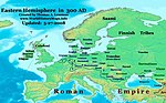
File:East-Hem 300ad (cropped).jpg (category Maps of the world showing history)
300 AD. Srivijaya borders are derived from Wikimedia's map of the World_in_300_CE.PNG (see above, #2 under Primary Sources) and the Wikipedia article about...
(968 × 602 (107 KB)) - 18:54, 13 May 2024