
GPS drawing, also known as GPS art, is a method of drawing where an artist uses a Global Positioning System (GPS) device and follows a pre-planned route...
13 KB (1,592 words) - 00:30, 20 May 2024
Global Positioning System (redirect from Gps)
The Global Positioning System (GPS), originally Navstar GPS, is a satellite-based radio navigation system owned by the United States government and operated...
178 KB (18,503 words) - 05:53, 25 May 2024

from various facts. The Connect the Dots drawing technique of GPS Drawing involves recording an artists GPS data only at certain points along the route...
4 KB (452 words) - 22:44, 20 October 2023

on geographical location Geo-fence warrant Geomessaging Geotagging GPS drawing GPS tracking Ingress – a location-based mobile game that makes use of this...
17 KB (2,062 words) - 19:35, 23 April 2024

Magic Roundabout Magic Roundabout, Swindon Web The Magic Roundabout at Swindon GPS Drawing tour around Magic Roundabout Google Maps satellite image view...
9 KB (890 words) - 09:48, 6 December 2023

marking a drawing "Tolerancing ISO 8015" is optional. The implication of this is that any drawing using ISO symbols can only be interpreted to ISO GPS rules...
44 KB (6,134 words) - 17:02, 27 March 2024

accomplishment For quantified self purposes such as fitness tracking GPS drawing In January 2019, the location of her iPhone as determined by her sister...
27 KB (3,152 words) - 13:50, 20 May 2024
Galileo (satellite navigation) (redirect from Galileo gps)
European political and military authorities do not have to rely on the US GPS, or the Russian GLONASS systems, which could be disabled or degraded by their...
107 KB (10,617 words) - 03:05, 5 May 2024

Ryumon Yasuda (painter / sculptor) Taikan Yokoyama (painter) Yassan (GPS drawing) Yukihiko Yasuda (painter) Yorozu Tetsugoro (painter) Yasushi Akutagawa...
21 KB (1,788 words) - 21:27, 12 May 2024

Geometric dimensioning and tolerancing (category Technical drawing)
which has some nuanced differences in its interpretation and rules (see GPS&V). The Y14.5 standard provides a fairly complete set of rules for GD&T in...
29 KB (2,683 words) - 04:13, 18 April 2024
ISO 128 (category Technical drawing)
assembly drawings ISO 8015:2011 Geometrical product specifications (GPS) — Fundamentals — Concepts, principles and rules ISO 8048:1984 Technical drawings — Construction...
11 KB (1,220 words) - 19:07, 29 September 2023

mounted on the deckhead. Navigational instruments, such as an autopilot and GPS, are used for manoeuvring the vessel in harbour and at sea. Radar can be...
28 KB (3,372 words) - 15:05, 19 May 2024
yarn – Definitions ISO 10135:2007 Geometrical product specifications (GPS) – Drawing indications for moulded parts in technical product documentation (TPD)...
74 KB (10,268 words) - 04:40, 29 April 2024

also designs, manufactures and markets GPS systems, including handheld GPS, in-car GPS, Bluetooth GPS and GPS with other positioning technologies. Quanta...
11 KB (957 words) - 17:20, 1 May 2024

Mahjong (section Drawing tiles)
persons with dementia". Int J Geriatr Psychiatry. 21 (7): 611–7. doi:10.1002/gps.1531. PMID 16779765. S2CID 6080864. Li, Junjie; Koyamada, Sotetsu; Ye, Qiwei;...
120 KB (13,116 words) - 21:57, 22 May 2024

Retrieved 14 April 2016. "Hillary Clinton: Putin is Arrogant and Tough". GPS with Fareed Zakaria. 27 July 2014. Archived from the original on 25 June...
471 KB (38,953 words) - 00:23, 23 May 2024

computerisation, electronic distance measurement (EDM), total stations, GPS surveying and laser scanning have to a large extent supplanted traditional...
38 KB (3,977 words) - 07:54, 13 May 2024

recreational activity, in which participants use a Global Positioning System (GPS) receiver or mobile device and other navigational techniques to hide and...
97 KB (10,147 words) - 06:56, 23 May 2024

had to leave the voyage in February, 2008. List of circumnavigations GPS drawing Tania Aebi Colin Angus Robin Lee Graham Roz Savage Katie Spotz Henk de...
45 KB (5,206 words) - 22:24, 21 January 2024

until satellite navigation systems (GPS) became available. INSs are still in common use on submarines (since GPS reception or other fix sources are not...
61 KB (7,244 words) - 07:24, 21 May 2024

Buswell & Nyberg (section GPS penis art)
penis across England and Scotland in GPS drawing. Using GPS tracking that users could log into and watch, the drawing was created in real time, and Buswell...
15 KB (1,646 words) - 05:17, 28 April 2024
Build KNX01Q Starts Rolling Out For The LG G Watch, Brings Offline Music And GPS Support (Though You Can't Use The Latter)". Android Police. Archived from...
213 KB (9,288 words) - 08:59, 21 May 2024

same year. The site is situated 12 km aerial distance from Kangla with the GPS coordinates of 24° 48' N and 93° 49' E. It covers a total area of around...
40 KB (4,622 words) - 14:34, 20 May 2024

Reagan to authorize the then-strictly-military global positioning system (GPS) for civilian use. South African Airways Flight 295, a 747-200M Combi, which...
183 KB (17,940 words) - 12:26, 24 May 2024
realize just how big the world is. Senku announces his next goal, to create a GPS powered by a massive radio tower and Senku's wireless telephone. At Ginro's...
46 KB (908 words) - 01:41, 8 May 2024
against Wales. In 1877, Rangers reached the Scottish Cup final; after drawing the first game, Rangers refused to turn up for the replay and the cup was...
252 KB (23,394 words) - 09:05, 25 May 2024

GIS. This has been enhanced by the availability of low-cost mapping-grade GPS units with decimeter accuracy in real time. This eliminates the need to post...
99 KB (13,053 words) - 00:28, 2 May 2024
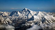
an American Everest expedition directed by Bradford Washburn anchored a GPS unit into the highest bedrock. A rock head elevation of 8,850 m (29,035 ft)...
234 KB (24,280 words) - 15:27, 18 May 2024
Geometrical Product Specification and Verification (GPS&V) is a set of ISO standards developed by ISO Technical Committee 213. The aim of those standards...
55 KB (5,839 words) - 10:58, 5 February 2024

Spatial memory (section GPS use and Spatial Cognition)
test. Global Positioning System (GPS) technology has revolutionized the way we navigate and explore our environment. GPS has become an essential tool in...
96 KB (11,597 words) - 17:47, 21 March 2024