 | Most of the Custer-Gallatin goes along the state's southern border, with some of it a part of North-West Wyoming. The forest area comprises a total of... 11 KB (1,065 words) - 03:46, 28 November 2023 |
 | Green Bottom Wildlife Management Area is located on former plantation lands of U.S. Congressman and Confederate General Albert G. Jenkins. The 1,096 acres... 6 KB (411 words) - 15:25, 21 March 2022 |
 | State James Madison. The Gallatin River is one of the best[according to whom?] whitewater runs in the Yellowstone-Teton Area. In June, when the snowmelt... 10 KB (1,059 words) - 12:08, 5 March 2024 |
 | Bozeman, Montana (category Cities in Gallatin County, Montana) Statistical Area, consisting of all of Gallatin County with a population of 118,960. It is the fastest growing micropolitan statistical area in the United... 80 KB (7,986 words) - 21:58, 15 April 2024 |
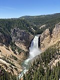 | Yellowstone National Park (redirect from Wildlife of Yellowstone National Park) Road, West Yellowstone, Gallatin County, MT", 11 data pages HAER No. MT-92, "Gallatin Entrance Road, West Yellowstone, Gallatin County, MT", 15 data pages... 168 KB (16,052 words) - 11:26, 19 April 2024 |
 | Sumner County, Tennessee (category Articles with MusicBrainz area identifiers) Cragfont State Historic Site Gallatin Steam Plant Wildlife Management Area Old Hickory Lock and Dam Wildlife Management Area (part) Rock Castle State Historic... 25 KB (2,352 words) - 03:29, 7 April 2024 |
Amelia Island Wildlife Management Area, also referred to as Amelia Island, is a 238 acres (96 ha) tract of protected land located in Treasure County, Montana... 2 KB (178 words) - 02:59, 3 February 2023 |
and the Gallatin River (in Gallatin County). On September 2, 1937, President Franklin D. Roosevelt signed into law the Federal Aid in Wildlife Restoration... 22 KB (2,453 words) - 02:10, 22 February 2024 |
 | Union County, Kentucky (section Protected areas) Illinois − west Gallatin County, Illinois −northwest Higginson-Henry Wildlife Management Area (state) Moffit Lake Recreation Area (county) U.S. Route... 18 KB (1,452 words) - 06:15, 31 March 2024 |
 | Lee Metcalf Wilderness (category Protected areas of Gallatin County, Montana) within Gallatin National Forest is also within the Greater Yellowstone Ecosystem and borders Yellowstone National Park. U.S. wilderness areas prohibit... 8 KB (418 words) - 23:49, 23 November 2023 |
 | named for the influence on the area by cowboy artist Charles M. Russell. Yellowstone Country, comprising Carbon, Gallatin, Park, Stillwater and Sweet Grass... 17 KB (1,502 words) - 11:41, 13 January 2023 |
 | Absaroka–Beartooth Wilderness (category Gallatin National Forest) Montana.[citation needed] The wilderness spans the Montana-Wyoming border on Gallatin, Custer and Shoshone National Forests and is composed of 944,000 acres... 11 KB (1,124 words) - 23:41, 21 March 2024 |
Fish and Wildlife Service (FWS) Bureau of Land Management (BLM) These wilderness areas cover about 4.5% of the United States' land area, an area larger... 171 KB (335 words) - 17:41, 15 March 2024 |
 | for Native Ecosystems, WildEarth Guardians, the Fund for Animals, Gallatin Wildlife Association, Great Old Broads for Wilderness, Hells Canyon Preservation... 53 KB (6,460 words) - 19:40, 17 March 2024 |
 | Missouri Headwaters State Park (category Protected areas of Gallatin County, Montana) the Gallatin River and the west by the Missouri River and the Madison River. Small parts of the park are also located on the east bank of the Gallatin River... 9 KB (818 words) - 04:58, 14 September 2023 |
 | Interstate 90 in Montana (category Transportation in Gallatin County, Montana) highway passes west of the Warm Springs State Wildlife Management Area. After passing the wildlife management area, the highway passes by Warm Springs and MT 48... 37 KB (2,100 words) - 13:05, 16 April 2024 |
 | Delta National Forest (redirect from Sunflower Wildlife Management Area) Sharkey County, and has an area of 60,898 acres (246.4 km2). Delta is operated as the Sunflower Wildlife Management Area. The forest is headquartered... 3 KB (223 words) - 08:12, 25 January 2024 |
 | Bitterroot National Forest (category Protected areas of Idaho County, Idaho) Trail Pass. This area, named for 9,154' Allan Mountain (in Idaho), lies mostly in Montana and is critical to the migration of wildlife between the wildlands... 11 KB (1,078 words) - 02:23, 9 January 2024 |
 | December 2023 Tennessee tornado outbreak (section Madison–Hendersonville–Gallatin–Castalian Springs, Tennessee) moved into neighborhoods to the southwest of Gallatin from the southwest. Multiple well-built homes in the area suffered partial to complete roof removal;... 70 KB (4,826 words) - 19:57, 17 April 2024 |
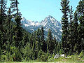
 | Geography of Montana (section Protected areas) the state's southern part, including the Gravelly Range, Madison Range, Gallatin Range, Absaroka Mountains, and Beartooth Mountains. The Beartooth Plateau... 76 KB (6,134 words) - 08:09, 7 July 2023 |
 | CSKT Bison Range (redirect from National Bison Range Wildlife Refuge) National Wildlife Refuge in 1908, the BR consists of approximately 18,524 acres (7,496 ha) within the Montana valley and foothill grasslands. Management of... 28 KB (2,707 words) - 01:20, 29 January 2024 |
 | Upper Missouri River Breaks National Monument (category Bureau of Land Management areas in Montana) north central Montana. Managed by the Bureau of Land Management (BLM), it is a series of badland areas characterized by rock outcroppings, steep bluffs,... 10 KB (835 words) - 03:48, 18 November 2023 |
 | American Prairie (category Protected areas of Blaine County, Montana) prairie ecosystem with migration corridors and native wildlife. This wildlife conservation area is being developed as a private project of the American... 60 KB (5,651 words) - 06:22, 23 November 2023 |
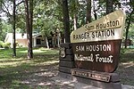 | Sam Houston National Forest (redirect from Double Lake Recreation Area) to the wildlife that live or forage there. Extra fees paid by hunters who use wildlife management areas are collected by Texas Parks and Wildlife Department... 25 KB (3,404 words) - 10:58, 4 February 2024 |
| Montana (redirect from Wildlife of Montana) Bureau of Land Management controls 8,100,000 acres (33,000 km2) of federal land. The U.S. Department of the Interior Fish and Wildlife Service administers... 242 KB (23,193 words) - 03:21, 15 April 2024 |
 | Bitterroot Valley around Missoula and the area just north of Yellowstone National Park along the Gallatin River, namely in Bozeman and the resort town... 7 KB (760 words) - 21:13, 3 March 2024 |
 | Kisatchie National Forest (category Protected areas of Grant Parish, Louisiana) Lacassine National Wildlife Refuge. The Red Dirt National Wildlife Management Preserve borders and is part of Kisatchie Hills Wilderness area. Sandstone Multi-Use... 32 KB (3,534 words) - 16:30, 12 April 2024 |
 | Manistee National Forest (category Important Bird Areas of Michigan) across the United States for the conservation of the remaining forests and wildlife, including on the federal level under the leadership of President Theodore... 10 KB (991 words) - 15:01, 8 February 2024 |
 | (USFS) — Gallatin, Custer, Beaverhead-Deerlodge, Caribou-Targhee, Bridger-Teton, and Shoshone National Forests United States Fish and Wildlife Service... 14 KB (1,586 words) - 13:54, 11 April 2024 |
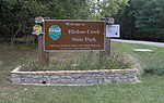 | Bledsoe Creek State Park (category Protected areas of Sumner County, Tennessee) off Tennessee State Route 25 (Hartsville Pike), roughly halfway between Gallatin and Hartsville, and 35 miles (56 km) northeast of Nashville. The park is... 11 KB (1,508 words) - 04:49, 20 April 2024 |