The General Bathymetric Chart of the Oceans (GEBCO) is a publicly available bathymetric chart of the world's oceans. The project was conceived with the... 8 KB (1,068 words) - 14:24, 12 October 2023 |
 | A bathymetric chart is a type of isarithmic map that depicts the submerged topography and physiographic features of ocean and sea bottoms. Their primary... 9 KB (1,920 words) - 18:30, 14 January 2024 |
The International Bathymetric Chart of the Southern Ocean (IBCSO) is a regional mapping initiative of the General Bathymetric Chart of the Oceans (GEBCO)... 8 KB (797 words) - 14:26, 22 December 2023 |
 | Bathymetry (redirect from Bathymetric) surface General Bathymetric Chart of the Oceans – Publicly available bathymetric chart of the world's oceans Global relief model – Model of Earth's relief... 27 KB (3,759 words) - 17:47, 15 March 2024 |
 | been done yet. The General Bathymetric Chart of the Oceans (GEBCO) is a publicly available bathymetric chart of the world's oceans. The project was conceived... 34 KB (4,075 words) - 00:28, 10 November 2023 |
 | Filippo Reef (category Reefs of the Pacific Ocean) shows a date of 1926. The topographic data supplied by the General Bathymetric Chart of the Oceans (GEBCO), however, shows a sea depth of 3.3 miles (5... 2 KB (287 words) - 15:05, 10 July 2023 |
 | Sandy Island, New Caledonia (category Islands of New Caledonia) such as the bathymetric data from the General Bathymetric Chart of the Oceans, which reported an elevation of 1 metre (3 feet) over the location of Sandy... 16 KB (1,809 words) - 12:19, 25 April 2024 |
 | the relevant geographical features. The Gazetteer includes also parts of the International Hydrographic Organization (IHO) General Bathymetric Chart of... 4 KB (308 words) - 03:35, 19 April 2024 |
directs the General Bathymetric Chart of the Oceans program.[citation needed] Establishment of the Chart Specifications Committee and International Charts: The... 11 KB (1,157 words) - 10:40, 29 April 2024 |
Germanium GE (i) General Electric Genetic Engineering (cf. GM) (s) Georgia (ISO 3166 digram) GEBCO – (a) General Bathymetric Chart of the Oceans GEC – (i) Great... 26 KB (2,736 words) - 11:23, 9 February 2024 |
 | Admiralty chart Bathymetric chart European Atlas of the Seas Nautical star Navigation room Portolan chart Dutch maritime cartography in the Age of Discovery... 17 KB (2,280 words) - 01:02, 15 September 2023 |
 | Edmund Hillary (category Commanders of the Order of Merit of the Republic of Poland) undersea feature in the Ross Sea, appears on the General Bathymetric Chart of the Oceans, published by the International Hydrographic Organization. Hillary married... 73 KB (7,077 words) - 19:05, 24 April 2024 |
 | Werner; et al. (20 June 2013). "The International Bathymetric Chart of the Southern Ocean (IBCSO) Version 1.0—A new bathymetric compilation covering circum‐Antarctic... 114 KB (14,809 words) - 19:30, 27 April 2024 |
Drygalski Basin (category Oceanic basins of the Southern Ocean) "Von Drygalski" in November 1995, in agreement with the General Bathymetric Chart of the Oceans Sub-Committee on Undersea Feature Names, but was changed... 1 KB (106 words) - 22:34, 29 March 2023 |
Ron G. Mason (category Alumni of Imperial College London) of Intertwining Efforts" (PDF). General Bathymetric Chart of the Oceans (GEBCO). Retrieved 16 August 2020. "National Geodetic Survey: Milestones of the... 5 KB (536 words) - 10:50, 3 June 2021 |
 | Oceanography (redirect from Maps of the Oceans) Study of extraterrestrial oceansPages displaying short descriptions of redirect targets Bathymetric chart – Map depicting the submerged terrain of bodies... 43 KB (5,128 words) - 02:30, 27 April 2024 |
Viaud Ridge (category Seamounts of the Indian Ocean) sector of the Indian Ocean, the submarine chain was still poorly defined in 2008, leading it to be listed at a General Bathymetric Chart of the Oceans summit... 9 KB (812 words) - 10:29, 27 September 2023 |
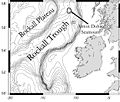 | Rockall Basin (category Sedimentary basins of Europe) Organization-Intergovernmental Oceanographic Commission General Bathymetric Chart of the Ocean (IHO-IOC GEBCO) Gazetteer of Undersea Feature Names" http://www.gebco... 9 KB (988 words) - 13:20, 31 March 2023 |
 | Challenger Deep (redirect from The deepest place in the ocean visited by a human) bathymetric charts based on the SeaBeam digital data. In just three days, they tracked 500 miles of sounding lines, and covered about 140 km2 of the Challenger... 173 KB (19,837 words) - 20:33, 10 April 2024 |
| of the Oceans – A publicly available bathymetric chart of the world's oceans General circulation model – A type of climate model that uses the Navier–Stokes... 226 KB (32,647 words) - 13:07, 24 February 2024 |
 | Underwater exploration (section Oceans) of ocean conditions beyond the continental shelf General Bathymetric Chart of the Oceans – Publicly available bathymetric chart of the world's oceans... 38 KB (4,737 words) - 22:05, 22 April 2024 |
 | and as such integrated into the General Bathymetric Chart of the Ocean. Software tools for the creation of Satellite-derived bathymetry range from desktop-based... 6 KB (615 words) - 09:59, 19 March 2024 |
 | There are 184 oceanic plateaus in the world, covering an area of 18,486,600 km2 (7,137,700 sq mi) or about 5.11% of the oceans. The South Pacific region... 11 KB (1,064 words) - 21:34, 24 March 2024 |
 | Physical oceanography (redirect from Ocean physics) its oceans, and the oceans are the source of the vast majority of water vapor that condenses in the atmosphere and falls as rain or snow on the continents... 31 KB (3,729 words) - 00:52, 2 April 2024 |
 | The Arctic Ocean is the shallowest and smallest of the world's five major oceans. It spans an area of approximately 14,060,000 km2 (5,430,000 sq mi) and... 65 KB (6,952 words) - 13:34, 29 April 2024 |
Canadian Hydrographic Service (redirect from Hydrographic Survey of Canada) (SDB); GEneral Bathymetric Charts of the Oceans (GEBCO) and the Seabed2030 project; autonomous hydrographic surface vehicles (AHSV); and the implementation... 11 KB (1,172 words) - 17:35, 21 April 2024 |
 | USS Mobjack (category Wikipedia articles incorporating text from the Dictionary of American Naval Fighting Ships) the Wayback Machine Theberge, Albert E. (October 4, 2011). "Scripps and NOAA - 90 Years of Intertwining Efforts" (PDF). General Bathymetric Chart of the... 48 KB (5,593 words) - 02:21, 10 July 2023 |
Search for Malaysia Airlines Flight 370 (category Wikipedia articles in need of updating from September 2016) began its return passage to China. The bathymetric survey charted around 208,000 square kilometres (80,000 sq mi) of seafloor through 17 December, when it... 185 KB (17,914 words) - 18:26, 24 April 2024 |
British Oceanographic Data Centre (category Environment of the United Kingdom) publishing the General Bathymetric Chart of the Oceans (GEBCO) Digital Atlas BODC is one of over 60 national oceanographic data centres that form part of the IOC... 8 KB (662 words) - 02:20, 13 April 2024 |
 | RV Horizon (category Research vessels of the United States) Explores the Ocean. University of California, San Diego. "IHO-IOC GEBCO Gazetteer" (pdf). General Bathymetric Chart of the Oceans. September 2007. "SIO Geological... 7 KB (697 words) - 06:06, 30 July 2023 |