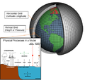
 | A geodesic grid is a spatial grid based on a geodesic polyhedron or Goldberg polyhedron. The earliest use of the (icosahedral) geodesic grid in geophysical... 12 KB (1,346 words) - 23:24, 5 January 2024 |
 | old geodesic standard (e.g. SAD69) or a non-geodesic surface (e. g. perfectly spherical surface) must be adopted, and will be covered by the grid. In... 43 KB (3,199 words) - 19:30, 1 March 2024 |
 | A geodesic dome is a hemispherical thin-shell structure (lattice-shell) based on a geodesic polyhedron. The rigid triangular elements of the dome distribute... 26 KB (3,361 words) - 02:55, 13 March 2024 |
 | the geodesic domes, hemispherical architectural structures designed by Buckminster Fuller, which geodesic polyhedra are named after. Geodesic grids used... 17 KB (1,129 words) - 14:31, 8 January 2024 |
| The study of geodesics on an ellipsoid arose in connection with geodesy specifically with the solution of triangulation networks. The figure of the Earth... 73 KB (8,411 words) - 18:49, 15 February 2024 |
 | Projected coordinate system (redirect from Grid references) called a projected coordinate reference system, planar coordinate system, or grid reference system – is a type of spatial reference system that represents... 21 KB (2,802 words) - 02:18, 12 April 2024 |
 | projections. The MODLAND Integerized Sinusoidal Grid, based on the sinusoidal projection, is a geodesic grid developed by the NASA's Moderate-Resolution Imaging... 4 KB (461 words) - 11:22, 3 April 2024 |
 | Azimuth (redirect from Geodesic azimuth) of the spheroid; geodetic azimuth (or geodesic azimuth) is the angle between north and the ellipsoidal geodesic (the shortest path on the surface of the... 14 KB (1,767 words) - 08:13, 27 March 2024 |
polygons Geodesic grid Spatial index Grid plan Grid reference Geocode hex map quadrilateralized spherical cube Quadtree R-tree Alpha-numeric grid Utility... 7 KB (903 words) - 20:59, 15 October 2023 |
 | Equal-area projection (redirect from Statistical grid) projection, used for geodesic grids. Authalic latitude Authalic radius Equiareal map (mathematics) Measure-preserving dynamical system Geodesic polygon area Snyder... 8 KB (801 words) - 00:50, 12 March 2024 |
 | General circulation model (section Grid) experiments use geodesic grids and icosahedral grids, which (being more uniform) do not have pole-problems. Another approach to solving the grid spacing problem... 44 KB (4,711 words) - 06:00, 18 March 2024 |
 | similarities to another alternative grid based on the icosahedron. List of map projections Spatial grid Geodesic grid Calabretta, Mark R.; Roukema, Boudewijn... 10 KB (1,011 words) - 11:45, 30 December 2023 |
| Ordnance Survey National Grid reference system (OSGB), also known as British National Grid (BNG), is a system of geographic grid references used in Great... 19 KB (2,130 words) - 10:22, 14 April 2024 |
| The Military Grid Reference System (MGRS) is the geocoordinate standard used by NATO militaries for locating points on Earth. The MGRS is derived from... 15 KB (2,133 words) - 06:55, 13 February 2024 |
| The Irish grid reference system is a system of geographic grid references used for paper mapping in Ireland (both Northern Ireland and the Republic of... 6 KB (657 words) - 12:25, 6 April 2022 |
| The United States National Grid (USNG) is a multi-purpose location system of grid references used in the United States. It provides a nationally consistent... 54 KB (6,255 words) - 06:23, 28 September 2023 |
A "regular" geodesic structure have members of equal length but strengths of members may vary depending on location in the geodesic "grid". Grotto An... 76 KB (9,171 words) - 21:16, 8 April 2024 |
which employ geodesic grids that are based on an icosahedron (refined by triangulation) instead of the more commonly used longitude/latitude grid. This has... 53 KB (5,532 words) - 21:46, 29 April 2024 |
 | discrete global grid scheme. It is similar to the quad sphere but is not equal-area. List of map projections Cube mapping Geodesic grid "Quadrilateralized... 7 KB (822 words) - 15:46, 19 March 2024 |
shapes Regular grid — consists of congruent parallelograms, or higher-dimensional analogue Unstructured grid Geodesic grid — isotropic grid on a sphere Mesh... 70 KB (8,344 words) - 02:48, 7 March 2024 |
 | Sinusoidal Strebe 1995 Snyder's equal-area polyhedral projection, used for geodesic grids. Tobler hyperelliptical Werner If the length of the line segment connecting... 58 KB (6,482 words) - 15:55, 11 January 2024 |
 | nearly equal shape and size. HEALPix Quadrilateralized spherical cube Geodesic grid Szalay, Alexander S.; Gray, Jim; Fekete, George; Kunszt, Peter Z.; Kukol... 2 KB (160 words) - 02:05, 4 December 2023 |
solutions for Rubik's Cube quaternary triangular mesh, a method to build a geodesic grid Quantum Corporation (NYSE stock ticker: QTM), see Companies listed on... 517 bytes (108 words) - 18:12, 15 November 2020 |
Destination Earth (European Union) Digital twin Geocode Geodesic grid Géoportail Geoweb Grid reference International Cartographic Association (ICA) International... 28 KB (3,068 words) - 12:27, 27 April 2024 |
ISEA may refer to: Icosahedral Snyder Equal Area, see geodesic grid Independent Schools Education Association Institute for Social and Economic Analyses... 956 bytes (139 words) - 21:09, 7 September 2023 |
manifolds, geodesics are paths of shortest distance between two points. The concept of geodesics becomes central in general relativity, since geodesic motion... 27 KB (3,173 words) - 02:08, 2 May 2024 |
| character is the keypad “key” number. (ex.006AG39) Military Grid Reference System List of geodesic-geocoding systems NGA's description Archived 2006-10-20... 3 KB (470 words) - 12:54, 13 December 2022 |
 | Wikimedia Commons has media related to Goldberg–Coxeter construction. Geodesic grid Quadrilateralized spherical cube Loop subdivision surface Catmull–Clark... 21 KB (1,928 words) - 12:23, 8 November 2023 |
| title (link) Torge & Müller (2012) Geodesy, De Gruyter, p.249 An online geodesic calculator (based on GeographicLib). An online geodesic bibliography.... 23 KB (3,562 words) - 08:57, 29 March 2024 |
| Geodetic datum (redirect from Geodesic datum) believe Earth was prolate (wider at the poles). The subsequent French geodesic missions (1735-1739) to Lapland and Peru corroborated Newton, but also... 29 KB (3,073 words) - 16:06, 31 December 2023 |