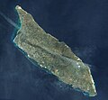
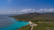
 | The geography of Aruba, located at the juncture of the South American and Caribbean tectonic plates, has been shaped by a complex interplay of geological... 45 KB (4,659 words) - 14:56, 27 April 2024 |
 | Aruba (/əˈruːbə/ ə-ROO-bə, Dutch: [aːˈrubaː] or [aːˈrybaː] , Papiamento: [aˈruba]), officially the Country of Aruba (Dutch: Land Aruba; Papiamento: Pais... 127 KB (13,008 words) - 20:21, 7 May 2024 |
 | Michielsbaai Vaersenbaai Westpunt Curaçao has a total of 37 beaches. Geography of Aruba Geography of Bonaire "The World Factbook – Central Intelligence Agency"... 18 KB (1,746 words) - 20:44, 18 September 2023 |
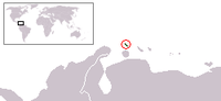
| Internet country code top-level domain: .aw Geography of Aruba Aruba is: an island, and a country of the Kingdom of the Netherlands Location: Northern Hemisphere... 9 KB (733 words) - 13:36, 27 January 2024 |
 | vehicles (Threats to Arikok National Park). Natural Pool Official Aruba Tourism Portal. "Park Map | Aruba National Park Foundation". Retrieved 2023-11-09.... 1 KB (83 words) - 16:58, 14 November 2023 |
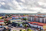
 | "Orange City"), the capital and most populous of Aruba's eight regions, is located on the southwestern coast of the island. In Papiamento, the local language... 28 KB (2,295 words) - 17:34, 12 March 2024 |
 | Category:Environment of Aruba Category:Geography of Aruba Category:Government of Aruba Category:Health in Aruba Category:History of Aruba Category:Politics of Aruba Category:Society... 5 KB (511 words) - 19:50, 24 April 2024 |
 | related to Aruba. Wikivoyage has a travel guide for Aruba. Geography of Aruba Islands of Aruba Caves of Aruba "Aruba's Beaches and Coves". Aruba.com. Retrieved... 6 KB (791 words) - 15:25, 11 May 2023 |
 | Jamanota (category Geography of Aruba) a hill situated within Aruba's Arikok National Park, reaching a height of 188 metres (617 ft) and holding the distinction of being the highest point... 24 KB (2,565 words) - 21:09, 7 May 2024 |
 | Geography of North America Geography of Canada Geography of the Caribbean Geography of Anguilla Geography of Antigua and Barbuda Geography of Aruba Geography... 30 KB (3,416 words) - 03:30, 2 January 2024 |
| The national flag of Aruba was adopted on 18 March 1976, along with the official anthem "Aruba Dushi Tera". The flag was partially designed by vexillologist... 12 KB (1,015 words) - 23:56, 14 April 2024 |
 | of Uruguay Geography of Venezuela Geography of Aruba Geography of Bonaire Geography of Curaçao Geography of the Falkland Islands Geography of French Guiana... 19 KB (1,605 words) - 14:02, 26 April 2024 |
 | The official languages of the Caribbean island-state of Aruba are Papiamento and Dutch, but most Arubans speak a minimum of four languages, including English... 6 KB (463 words) - 16:45, 24 February 2024 |
 | Dutch Caribbean (redirect from Aruba, Curaçao and Sint Maarten) grouped in the following ways. Geographically, by location in the Lesser Antilles (in alphabetical order): ABC islands, for Aruba, Bonaire, and Curaçao (within... 14 KB (899 words) - 15:28, 5 May 2024 |
 | The Parliament of Aruba (Papiamento: Parlamento di Aruba, Dutch: Staten van Aruba) is the unicameral legislature or parliament of Aruba. The parliament... 6 KB (233 words) - 05:50, 20 December 2023 |
 | The culture of Aruba, encompassing its language, music, and cuisine, is diverse and has been influenced by both regional and foreign cultures. One significant... 42 KB (4,628 words) - 07:18, 22 April 2024 |
 | This is a demography of the population of Aruba including population density, ethnicity, education level, health of the populace, economic status, religious... 20 KB (822 words) - 12:35, 30 March 2024 |
 | The economy of Aruba is an open system, with tourism currently providing the largest percentage of the country's income. Because of tourism's rapid growth... 11 KB (1,169 words) - 06:13, 1 May 2024 |
Defense on Aruba is the responsibility of the Kingdom of the Netherlands. The Netherlands Military forces that protect Aruba include the Royal Netherlands... 6 KB (741 words) - 22:09, 29 December 2023 |
 | provided as an overview of and topical guide to geography: Geography – study of Earth and its people. an academic discipline – a body of knowledge given to... 86 KB (7,725 words) - 16:56, 26 April 2024 |
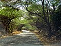
 | Santa Cruz[needs Dutch IPA] is a Region and Town in central Aruba, dominated by the Arikok National Park. The town is connected by Highway 7 from west... 4 KB (283 words) - 08:55, 8 August 2023 |
 | "Aruba Dushi Tera" ("Aruba Sweet Land", or "Aruba Lovely Country") is the national anthem of Aruba. It is a waltz written by Juan Chabaya Lampe and composed... 7 KB (298 words) - 18:14, 3 March 2024 |
 | (primary coordinates) GPX (secondary coordinates) This is a list of streams of Aruba. Streams (rooi from the Dutch word) are listed in alphabetical order... 3 KB (547 words) - 12:35, 30 December 2022 |
 | Frenchman's Pass (category Geography of Aruba) island of Aruba, nestled between coral cliffs in Balashi. Frenchman's pass is located north of the area known as Spanish Lagoon and near the remnants of the... 3 KB (226 words) - 10:09, 18 October 2023 |
ISO 3166-2:AW (category Geography of Aruba) ISO 3166-2:AW is the entry for Aruba in ISO 3166-2, part of the ISO 3166 standard published by the International Organization for Standardization (ISO)... 2 KB (142 words) - 11:55, 27 December 2023 |
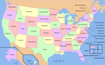 | used in the geographical sense, refers to the contiguous United States (sometimes referred to as the Lower 48, including the District of Columbia), Alaska... 49 KB (5,634 words) - 16:03, 9 May 2024 |
 | Politics of Aruba, a constituent country of the Kingdom of the Netherlands, takes place in a framework of a parliamentary representative democratic country... 2 KB (255 words) - 06:53, 20 March 2024 |
 | The island of Aruba is one of the constituent countries of the Kingdom of the Netherlands in the southern Caribbean Sea. Aruba has no administrative subdivisions... 3 KB (257 words) - 18:46, 18 November 2023 |
| minister of Aruba is de facto head of the executive branch of government. Together with Aruba's Council of Ministers, they form the executive branch of Aruban... 2 KB (35 words) - 22:18, 1 May 2024 |
 | Crotalus unicolor (redirect from Aruba Island Rattlesnake) Common names: Aruba rattlesnake, Aruba island rattlesnake, Cascabel (Papiamento). Crotalus unicolor, or the Aruba Island Rattlesnake, is a venomous pit... 5 KB (489 words) - 21:46, 21 April 2024 |