 | Malawi is a landlocked country in southeast Africa. It is wholly within the tropics; from about 9°30S at its northernmost point to about 17°S at the southernmost... 23 KB (1,324 words) - 14:25, 12 May 2024 |
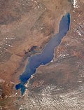 | the Government of Mozambique on June 10, 2011, while in Malawi a portion of the lake is included in Lake Malawi National Park. Lake Malawi is a meromictic... 51 KB (5,354 words) - 17:06, 1 May 2024 |
 | Malawi (/məˈlɑːwi/; lit. 'flames' in Chichewa and Tumbuka), officially the Republic of Malawi and formerly known as Nyasaland, is a landlocked country... 117 KB (11,258 words) - 14:18, 12 May 2024 |
 | The economy of Malawi is $7.522 billion by gross domestic product as of 2019, and is predominantly agricultural, with about 80% of the population living... 26 KB (2,123 words) - 04:20, 17 January 2024 |
| See ISO 3166-2:MW Internet country code top-level domain: .mw Geography of Malawi Malawi is: a landlocked country Location: Eastern Hemisphere and Southern... 12 KB (749 words) - 21:13, 3 May 2024 |
In Malawi, the NSN length is usually seven or nine digits. To call Malawi, the following format is used: +265 1 XXX XXX or +265 X XXXX XXXX Within Malawi... 2 KB (58 words) - 11:11, 30 April 2024 |
 | In geography, a cape is a headland, peninsula or promontory extending into a body of water, usually a sea. A cape usually represents a marked change in... 2 KB (171 words) - 14:07, 5 April 2024 |
This is a list of renamed places in Malawi. The British colony of Nyasaland was renamed Malawi upon independence in 1964. Fort Hill → Chitipa (1964) Fort... 1 KB (64 words) - 03:18, 8 March 2022 |
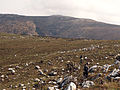 | Mafinga Central (category Geography of Malawi) border of Zambia and Malawi. At 2,339-metre (7,674 ft) it is likely to be the highest mountain in Zambia. It is most easily accessed from the town of Chisenga... 2 KB (172 words) - 10:34, 1 November 2023 |
The History of Malawi covers the area of present-day Malawi. The region was once part of the Maravi Empire (Maravi was a kingdom which straddled the current... 34 KB (4,535 words) - 07:37, 31 March 2024 |
 | provided as an overview of and topical guide to geography: Geography – study of Earth and its people. an academic discipline – a body of knowledge given to... 86 KB (7,725 words) - 16:56, 26 April 2024 |
 | Malawi is divided into 28 districts within three regions. Each District is headed by a District Commissioner: ISO 3166-2:MW "Parliament of Malawi - Official... 4 KB (75 words) - 18:11, 14 March 2023 |
 | Southern Africa (redirect from Geography of Southern Africa) Lesotho, Madagascar, Malawi, Mauritius, Mozambique, Namibia, South Africa, Zambia, and Zimbabwe. In cultural geography, the island country of Madagascar is often... 37 KB (3,943 words) - 14:01, 10 May 2024 |
| Politics of Malawi takes place in a framework of a presidential representative democratic republic, whereby the President of Malawi is both head of state... 24 KB (2,758 words) - 12:26, 1 April 2024 |
 | Malawi is a land-locked country in southeastern Africa situated along the southernmost arm of the East African Rift-Valley System between latitudes 9°22’... 16 KB (1,393 words) - 14:32, 4 May 2024 |
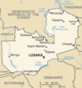
 | Lilongwe (redirect from Capital of Malawi) is the capital and largest city of Malawi. It has a population of 989,318 as of the 2018 Census, up from a population of 674,448 in 2008. In 2020 that figure... 35 KB (3,425 words) - 07:28, 29 April 2024 |
 | Malawi is divided into 3 regions which comprise a combined total of 28 districts. The regions of Malawi are: Northern Population: 2,289,780 (2018 census)... 2 KB (65 words) - 18:59, 3 February 2024 |
 | Cichlid (redirect from Cichlids of lake Malawi) Lakes Tanganyika, Victoria, Malawi, and Edward. Their diversity in the African Great Lakes is important for the study of speciation in evolution. Many... 101 KB (9,745 words) - 17:59, 1 May 2024 |
 | This is a list of towns and cities in Malawi: Chitipa Chilumba Ekwendeni Karonga Likoma Livingstonia Mzimba Mzuzu Nkhata Bay Rumphi Chintheche Embangweni... 1 KB (69 words) - 05:39, 24 April 2024 |
University of Malawi (UNIMA) is a public university established in 1965 and until 4 May 2021, when the university underwent a delinking, was composed of four... 18 KB (2,003 words) - 09:39, 16 March 2024 |
 | forest reserves. The flora and fauna are much influenced by the geography of the region. Malawi is a land-locked country, dominated by the Great Rift Valley... 11 KB (1,331 words) - 14:45, 9 June 2022 |
 | Uganda to the west, and Sudan to the northwest. Malawi – A colony of the United Kingdom at the time, Malawi joined on July 13, 1964, one week after independence... 9 KB (864 words) - 07:03, 30 March 2024 |
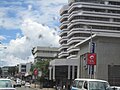 | Blantyre (redirect from Geography of Blantyre) (UK: /ˈblænˌtaɪə/) is Malawi's centre of finance and commerce, and its second largest city, with a population of 800,264 as of 2018[update]. It is sometimes... 42 KB (4,163 words) - 01:15, 14 May 2024 |
 | Ismailia 27°00′N 30°00′E / 27.000°N 30.000°E / 27.000; 30.000 The geography of Egypt relates to two regions: North Africa and West Asia. Egypt has coastlines... 20 KB (2,837 words) - 20:52, 15 April 2024 |
 | Border countries: Angola for 1,110 km, Democratic Republic of the Congo for 1,930 km, Malawi for 837 km, Mozambique for 419 km, Namibia for 233 km, Tanzania... 8 KB (915 words) - 13:17, 28 March 2024 |
languages and their Guthrie identifications are: Tumbuka (N21) Tonga language (Malawi) (N15) Chewa (Nyanja) (N31) Sena group (N40): Chikunda-Nyungwe (N42, N43)... 1 KB (91 words) - 12:25, 23 October 2022 |
 | Travel. 2012. Retrieved July 24, 2017. "Madagascar-GEOGRAPHY". countrystudies.us. U. S. Library of Congress. Retrieved 15 May 2021. Murray, N.J.; Phinn... 30 KB (2,866 words) - 20:13, 9 April 2024 |
 | The Central Region of Malawi, population 7,523,340 (2018), covers an area of 35,592 km2. Its capital city is Lilongwe, which is also the national capital... 5 KB (306 words) - 19:28, 19 March 2024 |
 | Piracy Problem." (2012). "Geography of Seychelles - Archive - Seychelles Nation". www.nation.sc. Retrieved 2020-05-26. "Geography of Seychelles | Mauritius... 31 KB (1,950 words) - 11:28, 13 January 2024 |
Archipelago), the Comoros, the French Southern Territories, Madagascar, Malawi, Mauritius, Mayotte, Mozambique, Réunion, Zambia, and Zimbabwe in Eastern... 19 KB (316 words) - 01:19, 12 May 2024 |