 | Uttar Pradesh is India's fourth largest state by land area, and most populous state, located in the north-central part of the country. It spreads over... 10 KB (1,327 words) - 22:14, 29 January 2024 |
The climate of Uttar Pradesh (U.P.) is primarily defined as humid subtropical with dry winter (Cwa) type with parts of Western U.P. as hot semi-arid (BSh)... 31 KB (2,154 words) - 20:41, 2 February 2024 |
 | Western Uttar Pradesh is a region in India that comprises the western districts of Uttar Pradesh state, including the areas of Rohilkhand and those where... 34 KB (2,782 words) - 10:01, 25 April 2024 |
 | Uttar Pradesh is the most populous state in India with a population of nearly 240 million people. The economy of Uttar Pradesh is the fifth largest among... 35 KB (3,530 words) - 13:38, 22 April 2024 |
 | Uttar Pradesh is the second largest religion in the state with 38,483,967 adherents in 2011, forming 19.26% of the total population. Muslims of Uttar... 50 KB (4,790 words) - 00:17, 25 April 2024 |
 | The Emblem of Uttar Pradesh is the official seal of the government of the Indian state of Uttar Pradesh. The emblem was originally designed in 1916 for... 6 KB (555 words) - 16:05, 3 January 2023 |
| rate: 29th Geography of Uttar Pradesh Uttar Pradesh is: an Indian state Population of Uttar Pradesh: 199,812,341 (2011) Area of Uttar Pradesh: 243,290 km2(93... 12 KB (971 words) - 12:18, 30 October 2023 |
 | Uttar Pradesh (/ˌʊtər prəˈdɛʃ/; lit. 'North Province') is a state in northern India. With over 241 million inhabitants, it is the most populated state... 197 KB (15,902 words) - 13:28, 23 April 2024 |
Moradabad The Indian state of Uttar Pradesh borders with Nepal and the Indian states of Bihar, Jharkhand, Chhattisgarh, Madhya Pradesh, Rajasthan, Haryana,... 22 KB (453 words) - 23:08, 18 April 2024 |
Government of Uttar Pradesh (ISO: Uttar Pradesh Sarkār; often abbreviated as GoUP) is the subnational government of the Indian state of Uttar Pradesh with the... 25 KB (1,653 words) - 12:42, 16 April 2024 |
 | populous state of India, Uttar Pradesh contains many historical monuments and places of religious significance. Geographically, Uttar Pradesh is very diverse... 29 KB (2,932 words) - 22:33, 10 February 2024 |
 | Indian state of Uttar Pradesh on the banks of the Gomti, which Hindus consider a holy river. The city is the administrative headquarters of Sultanpur district... 14 KB (1,278 words) - 13:48, 10 April 2024 |
the Indian state of Uttar Pradesh. Patti is located at 25°55′N 82°12′E / 25.92°N 82.2°E / 25.92; 82.2. It has an average elevation of 84 metres (275 feet)... 4 KB (272 words) - 19:09, 23 January 2021 |
 | The Uttar Pradesh Metro Rail Corporation (UPMRC) is a joint venture company that operates the Lucknow Metro, Agra Metro and Kanpur Metro.The Varanasi... 17 KB (1,060 words) - 23:38, 24 April 2024 |
 | Ghaziabad (redirect from History of Ghaziabad, Uttar Pradesh) state of Uttar Pradesh and a part of Delhi NCR. It is the administrative headquarters of Ghaziabad district and is the largest city in western Uttar Pradesh... 43 KB (3,396 words) - 13:20, 10 April 2024 |
Fatehpur is a city in the state of Uttar Pradesh, India. Situated between the rivers Ganga and Yamuna, the city is named after Babu Fateh Chandra, who... 13 KB (925 words) - 08:07, 11 March 2024 |
 | Doab (redirect from Doab, Uttar Pradesh) the following states and districts form part of The Doab: Uttarakhand: Dehradun and Haridwar Uttar Pradesh: Saharanpur, Shamli, Muzaffarnagar, Baghpat... 16 KB (1,048 words) - 20:12, 16 February 2024 |
 | Indian state of Uttar Pradesh. It is located 228 km southeast of state capital Lucknow. Demographically, Jaunpur resembles the rest of the Purvanchal... 22 KB (2,136 words) - 13:52, 19 April 2024 |
panchayat in Muzaffarnagar district in the Indian state of Uttar Pradesh. As of 2001, it had a population of 17,186. Shahpur is located at 29°21′N 77°33′E /... 4 KB (186 words) - 08:02, 29 May 2023 |
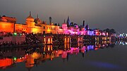
 | The Culture of Uttar Pradesh is an Indian culture which has its roots in Hindi, Bhojpuri and Urdu literature, music, fine arts, drama and cinema. Lucknow... 15 KB (1,623 words) - 13:42, 29 October 2023 |
 | Bilaspur is a town and tehsil in Rampur district, Uttar Pradesh. India on the bank of Bhakra river. It is situated on the Nainital road 30 kilometres... 5 KB (301 words) - 18:44, 2 February 2024 |
 | Harit Pradesh is a proposed new state of India comprising the western parts of the state of Uttar Pradesh. The etymology derives from harit, meaning 'green'... 42 KB (3,750 words) - 12:46, 29 April 2024 |
in the Bulandshahr district of the Indian state of Uttar Pradesh. It is situated at a latitude of 28.53°N and a longitude of 78.05°E. Khanpur is divided... 5 KB (536 words) - 03:52, 30 January 2024 |
 | district of the Indian state of Uttar Pradesh. Lakhimpur is located at 27°57′N 80°46′E / 27.95°N 80.77°E / 27.95; 80.77. It has an average elevation of 147... 24 KB (2,058 words) - 15:44, 3 March 2024 |
 | pronunciation) is a city, and the municipality headquarter of Rampur District in the Indian state of Uttar Pradesh. It was formerly known for its various industries... 46 KB (4,067 words) - 16:48, 5 April 2024 |
Uttar Pradesh Congress Committee (UPCC) is the Pradesh Congress Committee (state wing) of the Indian National Congress (INC) serving in the state of Uttar... 22 KB (255 words) - 02:59, 17 April 2024 |
Indian state of Uttar Pradesh. Ranipur is located at 25°15′N 79°04′E / 25.25°N 79.07°E / 25.25; 79.07. It has an average elevation of 205 metres (672 feet)... 4 KB (271 words) - 22:09, 12 January 2023 |
 | Banda district in the state of Uttar Pradesh, India. Banda is divided among north, east, west and south Banda. Banda lies south of the Yamuna river in the... 27 KB (2,456 words) - 12:02, 22 April 2024 |
 | Tamil Nadu Geography of Telangana Geography of Tripura Geography of Uttar Pradesh Geography of Uttarakhand Geography of West Bengal Demographics of India Ethnic... 59 KB (4,571 words) - 00:02, 12 April 2024 |
 | Barabanki (redirect from Barabanki, Uttar Pradesh) state of Uttar Pradesh. It is the administrative headquarters of Barabanki district and a part of Ayodhya division. The city is about 30 km east of Lucknow... 18 KB (1,112 words) - 12:48, 22 April 2024 |