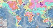
 | A geologic map or geological map is a special-purpose map made to show various geological features. Rock units or geologic strata are shown by color or... 12 KB (1,560 words) - 21:30, 16 November 2023 |
 | Cadastral map Climatic map Geologic map Historical map Linguistic map Nautical map Physical map Political map Relief map Resource map Road map Star map Street... 33 KB (4,185 words) - 21:14, 15 April 2024 |
 | world map is a map of most or all of the surface of Earth. World maps, because of their scale, must deal with the problem of projection. Maps rendered... 9 KB (834 words) - 03:05, 18 March 2024 |
 | the table of geologic time presented in this article conforms to the nomenclature, ages, and colour codes set forth by the ICS. The geologic time scale... 172 KB (9,395 words) - 04:29, 22 April 2024 |
 | often known as Quaternary geology, after the Quaternary period of geologic history, which is the most recent period of geologic time. Magma is the original... 87 KB (9,583 words) - 17:16, 26 April 2024 |
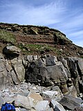 | Bedrock (redirect from Subsurface (geology)) experience subsurface weathering at its upper boundary, forming saprolite. A geologic map of an area will usually show the distribution of differing bedrock types... 5 KB (473 words) - 06:29, 27 April 2024 |
Geologic mapping of Georgia is the creation of geologic maps—special-purpose maps made to show geological features—of the State of Georgia in the United... 30 KB (4,061 words) - 16:00, 5 July 2023 |
 | Stratum (redirect from Strata (geology)) Mexico Archaeological horizon Bed (geology) Geological formation Geologic map Geologic unit Lamination (geology) Law of superposition Salvador, A. ed... 7 KB (703 words) - 07:24, 22 March 2024 |
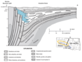 | A cross section or cross-section, in geology, is a diagram representing the geologic features intersecting a vertical plane, and is used to illustrate... 4 KB (395 words) - 01:30, 3 January 2024 |
 | Puget Sound faults (section Geological setting) K. D. (2002), "Geologic Map of Washington — Northwest Quadrant" (PDF), Washington Division of Geology and Earth Resources, Geologic Map GM-50, 3 sheets... 178 KB (20,728 words) - 21:02, 7 November 2023 |
 | Strike and dip (redirect from Strike (geology)) In geology, strike and dip is a measurement convention used to describe the plane orientation or attitude of a planar geologic feature. A feature's strike... 14 KB (1,553 words) - 01:23, 7 November 2023 |
| A geologic province is a spatial entity with common geologic attributes. A province may include a single dominant structural element such as a basin or... 4 KB (161 words) - 17:56, 3 July 2021 |
 | Geologic modelling, geological modelling or geomodelling is the applied science of creating computerized representations of portions of the Earth's crust... 20 KB (2,267 words) - 00:17, 28 March 2024 |
 | Contour line (redirect from Contour map) label placement. Aeronautical chart Bathymetry Dymaxion map Fall line (topography) Geologic map Marching squares Planform Tensor field TERCOM Courant,... 36 KB (4,352 words) - 17:14, 17 April 2024 |
Volcanological Survey of Indonesia (redirect from Vulcanology and Geological Hazard Mitigation Center) gunungapi (Geologic map of volcano) Peta daerah bahaya gunungapi (Volcanic hazard map) Peta kawasan rawan bencana gunungapi (Volcanic hazard map of volcano)... 6 KB (412 words) - 15:47, 24 July 2023 |
 | Mareta N. West. 1977. Geologic map of the west side of the Moon. USGS Map 1-1034. Scott, David H., and Michael H. Carr. 1978. Geologic map of Mars. USGS IMAP... 5 KB (404 words) - 05:55, 28 April 2024 |
 | Cartography of the United States (redirect from Map of florida) published a map of the United States in 1850. The National Program for Topographic Mapping was initiated in 1884 by the United States Geological Survey (USGS)... 2 KB (176 words) - 14:40, 19 April 2024 |
 | began to shift towards the gathering of basic geologic information. In 1938 a new 1:500,000-scale geologic map was published. During the 1940s and 1950s,... 8 KB (1,084 words) - 19:47, 21 October 2022 |
 | (2008) Geologic Map of Mount St. Helens, Washington Prior to the 1980 Eruption. Scale 1:62,500, Open-File Report no. 2002-468. U.S. Geological Survey... 14 KB (1,215 words) - 00:48, 10 February 2023 |
 | Ramapo Fault (category Geology of New York (state)) Letters, 71(3). "Geologic Faults and Earthquakes in New Jersey". New Jersey Geological Survey. 2009. Retrieved October 24, 2009. "Geologic Map of New Jersey:... 18 KB (2,264 words) - 21:18, 10 April 2024 |
 | correlate geologic strata across wide distances between outcrops and exposures of rock strata. Formations were at first described as the essential geologic time... 10 KB (1,077 words) - 15:10, 16 September 2023 |
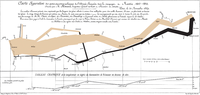
 | cultural regions began to appear in the 19th Century. The first known geologic map of surficial rock types was published by Jean-Étienne Guettard and Philippe... 15 KB (1,730 words) - 08:49, 10 December 2023 |
 | In modern mapping, a topographic map or topographic sheet is a type of map characterized by large-scale detail and quantitative representation of relief... 20 KB (2,043 words) - 18:20, 5 April 2024 |
 | above lunar geologic time scale in that the Cryptic and Basin Groups 1–9 (both of which are only informal terms that are not used in geologic maps) comprise... 13 KB (1,514 words) - 05:54, 24 January 2024 |
 | where the fault can be seen or mapped on the surface. A fault trace is also the line commonly plotted on geologic maps to represent a fault. A fault zone... 32 KB (3,483 words) - 08:04, 22 April 2024 |
 | Homestake Mine (South Dakota) (section Geology) : J36 Gold production and ore ledge discovery: J4–J8 Geologic map of the Black Hills Geologic cross section. The Homestake Formation has been deformed... 15 KB (1,828 words) - 04:10, 15 March 2024 |
 | A thematic map is a type of map that portrays the geographic pattern of a particular subject matter (theme) in a geographic area. This usually involves... 27 KB (3,063 words) - 14:08, 19 January 2024 |
 | In cartography, geology, and robotics, a topological map is a type of diagram that has been simplified so that only vital information remains and unnecessary... 2 KB (133 words) - 21:06, 12 October 2023 |
Commission for the Geological Map of the World (CGMW or CCGM) is an association and a standardization body in the field of geology and stratigraphy. Its... 2 KB (195 words) - 16:09, 18 December 2023 |
 | William Maclure (section Geological map) remaining glaciers in Yosemite National Park. Biography portal Geology portal Geologic map of Georgia Chisholm 1911. Bantu, Richard E. (1948). "New Harmony's... 22 KB (1,854 words) - 18:07, 7 January 2024 |