 | The Geospatial Information Authority of Japan (国土地理院, Kokudo Chiri-in), or GSI, is the national institution responsible for surveying and mapping the... 6 KB (598 words) - 21:22, 10 January 2024 |
 | on paper maps. On February 28, 2023, the Geospatial Information Authority of Japan announced that the number of islands had been updated to 14,125 through... 21 KB (1,229 words) - 03:22, 14 April 2024 |
Mountains of Japan. Mt. Nakanodake:Hiking route|Snow Country "List of Japanese mountains" (in Japanese). Geospatial Information Authority of Japan. Retrieved... 28 KB (126 words) - 16:58, 31 March 2024 |
 | by prefectures and municipalities (as of October 1)] (in Japanese). Geospatial Information Authority of Japan. December 26, 2019. Archived from the original... 173 KB (15,154 words) - 01:21, 17 April 2024 |
 | 2024 Noto earthquake (redirect from 2024 Sea of Japan earthquake) distribution data] (in Japanese). Geospatial Information Authority of Japan. 7 January 2024. Retrieved 18 January 2024. "Japan quake death toll tops 100"... 238 KB (22,917 words) - 16:10, 17 April 2024 |
 | Tokyo (redirect from Tokyo, Japan) "Mountains of Tokyo Metropolis" (in Japanese). Geospatial Information Authority of Japan. Retrieved April 28, 2020. "東京都の人口(推計)とは" [Population of Tokyo(estimate)]... 148 KB (11,614 words) - 04:35, 18 April 2024 |
 | Subsidence (category CS1 uses Japanese-language script (ja)) settling and compacting of unconsolidated sediment from the shaking of an earthquake. The Geospatial Information Authority of Japan reported immediate subsidence... 16 KB (2,132 words) - 08:15, 22 January 2024 |
 | Amami Islands (redirect from History of the Amami Islands) part of the Ryukyu Islands, and is southwest of Kyushu. Administratively, the group belongs to Kagoshima Prefecture, Japan. The Geospatial Information Authority... 23 KB (2,388 words) - 21:46, 26 September 2023 |
 | (10月1日時点)" [Areas of prefectures, cities, towns and villages (October 1)] (PDF). Geospatial Information Authority of Japan. Ministry of Land, Infrastructure... 63 KB (3,633 words) - 03:59, 9 April 2024 |
 | Japan: Nippon, Kiusiu, Sikok, Yesso and the Japanese Kuriles" a map from 1855 Terrain of Japan – GJI Maps (Geospatial Information Authority of Japan)... 148 KB (14,669 words) - 06:09, 2 April 2024 |
| 1st year National area of each prefecture municipality (as of October 1)" (in Japanese). Geospatial Information Authority of Japan. 26 December 2019. Archived... 9 KB (750 words) - 19:46, 24 March 2024 |
 | Ministry of Internal Affairs and Communications of Japan Intercensal Adjustment of Current Population Estimates 2010 – 2015 "地形分類" (PDF). Geospatial Information... 138 KB (7,815 words) - 13:31, 16 April 2024 |
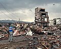
 | 2011 Tōhoku earthquake and tsunami (redirect from Great Japan Earthquake of 2011) caused by 2011 Tōhoku earthquake and tsunami] (in Japanese). Geospatial Information Authority of Japan. 14 April 2011. Archived from the original on 20... 237 KB (22,317 words) - 17:39, 12 April 2024 |
 | Derivation of Extensive Coordinate Conversion Formulae in the Gauss-Krüger Projection, Bulletin of the Geospatial Information Authority of Japan, 60, pp 1–6... 17 KB (2,610 words) - 23:05, 29 February 2024 |
 | Mount Hiyori (category Articles needing translation from Japanese Wikipedia) is Japan's lowest mountain. From 1991 to 1996, and again on April 9, 2014, after the Tohoku tsunami, the Geospatial Information Authority of Japan recognized... 4 KB (404 words) - 22:00, 2 March 2024 |
Germany Geographical Society of Ireland Geospatial Information Authority of Japan Geological Survey of India Geological Survey of Ireland Global Security Initiative... 1 KB (166 words) - 09:14, 22 January 2024 |
 | Prefectures, Cities, Towns and Villages in Japan" (in Japanese). Geospatial Information Authority of Japan. 29 June 2023. Archived from the original on... 73 KB (4,186 words) - 02:32, 11 April 2024 |
in Japan - Japan Meteorological Agency 日本の主な山岳標高 (Elevation of Principal Mountains in Japan) - Geospatial Information Authority of Japan (in Japanese)... 43 KB (328 words) - 21:01, 24 February 2024 |
 | displaying short descriptions of redirect targets List of Japanese typographic symbols Geospatial Information Authority of Japan – institution responsible... 15 KB (161 words) - 03:48, 21 September 2023 |
 | Nanpō Islands (category Archipelagoes of Japan) Okinotorishima Minamitorishima The Geospatial Information Authority of Japan, a government agency that is responsible for standardization of place names, does not... 3 KB (384 words) - 05:15, 13 August 2023 |
Government, 2014, retrieved 30 April 2021 地名等の英語表記規程 Geospatial Information Authority of Japan, the Ministry of Land, Infrastructure, Transport and Tourism... 15 KB (1,674 words) - 22:55, 9 October 2023 |
 | identical symbol) "Japanese Post Office". Emojipedia. Retrieved 2014-10-05. Geospatial Information Authority of Japan (GSI). "地図記号一覧" (in Japanese). Marín Silva... 15 KB (1,276 words) - 12:08, 25 February 2024 |
 | Human Shadow Etched in Stone (category Monuments and memorials in Japan) "地理院地図" (in Japanese). Geospatial Information Authority of Japan. Retrieved 2017-11-04. "ヒロシマの記録 消えた「原爆十景」追う" (in Japanese). Chugoku Shimbun. 2007-04-30... 15 KB (1,378 words) - 20:17, 29 March 2024 |
 | Yabiji (category Natural monuments of Japan) the Geospatial Information Authority of Japan called for standardization of the name upon the publication of a 1/25,000-scale topographic map of Yabiji... 24 KB (2,765 words) - 14:50, 6 March 2024 |
 | Triangulation station (category CS1 Japanese-language sources (ja)) [About Class 1 Triangulation Stone Markers] (in Japanese). Geospatial Information Authority of Japan. Archived from the original on 27 April 2015. Retrieved... 14 KB (1,580 words) - 12:11, 16 January 2024 |
Global Map (category Geographic data and information) environment. It is developed through the cooperation of National Geospatial Information Authorities (NGIAs) in the world. An initiative to develop Global Map... 6 KB (655 words) - 10:26, 17 February 2024 |
 | Survey of India Morocco ANCFCC Republic of Ireland Ordnance Survey Ireland Italy Istituto Geografico Militare Japan Geospatial Information Authority of Japan... 10 KB (1,049 words) - 17:22, 24 November 2023 |
 | Honshu (redirect from Largest island of Japan) homeless. "Map of Horizontal Land Movement caused by 2011/3/11 M9.0 earthquake" (PDF) (in Japanese). Geospatial Information Authority of Japan. March 19,... 33 KB (2,176 words) - 16:54, 7 April 2024 |
Figures". Embassy of the Republic of Indonesia, Washington DC. Retrieved 13 June 2020. "我が国の島を数えました". Geospatial Information Authority of Japan. Archived from... 25 KB (1,231 words) - 21:11, 16 April 2024 |
 | Geospatial Information Authority of Japan (GSI)". 2023-07-01. Retrieved 2023-10-23. Nolan, Professor William. "Geography of Ireland". Government of Ireland... 66 KB (1,626 words) - 17:45, 12 April 2024 |