 | Shebaa Farms (category Golan Heights) the intersection of the Lebanese–Syrian border and the Israeli-occupied Golan Heights. The territory is named for the farms within it which were historically... 40 KB (4,562 words) - 10:41, 26 April 2024 |
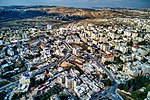
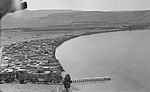
 | Fiq, Syria (redirect from Fiq (Golan)) Fiq (Arabic: فيق) was a Syrian town in the Golan Heights that administratively belonged to Quneitra Governorate. It sat at an altitude of 349 meters (1... 15 KB (1,450 words) - 09:59, 30 December 2023 |
 | Ghajar (category Populated places in the Golan Heights) on the border between Lebanon and the Israeli-occupied portion of the Golan Heights. In 2022, it had a population of 2,806. Control over Ghajar has... 22 KB (2,184 words) - 20:43, 2 December 2023 |
 | Jerusalem) from Jordan (which Jordan had controlled since 1949), and the Golan Heights from Syria. The Suez Canal, the east bank of which was now occupied... 41 KB (4,181 words) - 14:50, 21 April 2024 |
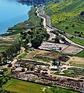
 | Banias (category Classical sites on the Golan Heights) Medieval Hebrew: פמייס, etc.; Ancient Greek: Πανεάς) is a site in the Golan Heights near a natural spring, once associated with the Greek god Pan. It... 50 KB (5,850 words) - 12:23, 29 April 2024 |
 | fertile Marjeyoun plains extending southward into the Galilee plains and the Golan Heights. On June 10, 1179, during the Battle of Marj Ayyun, an Ayyubid army... 16 KB (1,395 words) - 22:41, 26 April 2024 |
 | intrigue, catalogued as "Oaths and denials", and lists 7 cities located in the Golan area. Ayyab was the king of Aštartu. He authored of one surviving letter... 6 KB (648 words) - 02:26, 29 November 2023 |
 | (1945). Village Statistics, April, 1945. Guérin, V. (1875). Description Géographique Historique et Archéologique de la Palestine (in French). Vol. 2: Samarie... 45 KB (4,587 words) - 10:47, 7 May 2024 |
 | Central Asia (redirect from Central Asian region) Ferrand, Gabriel (1913), "Ibn Batūtā", Relations de voyages et textes géographiques arabes, persans et turks relatifs à l'Extrème-Orient du 8e au 18e siècles... 145 KB (13,488 words) - 12:19, 11 May 2024 |
 | (1945). Village Statistics, April, 1945. Guérin, V. (1868). Description Géographique Historique et Archéologique de la Palestine (in French). Vol. 1: Judee... 39 KB (3,642 words) - 01:18, 24 April 2024 |
 | (1945). Village Statistics, April, 1945. Guérin, V. (1874). Description Géographique Historique et Archéologique de la Palestine (in French). Vol. 2: Samarie... 38 KB (3,826 words) - 11:52, 29 April 2024 |
 | at the time, nominally included Homs, the Beqaa Valley, Hauran, and the Golan Heights as part of its territories. With military support from Sharaf al-Din... 126 KB (13,521 words) - 12:24, 7 May 2024 |
 | April, 1945. Government of Palestine. Guérin, V. (1880). Description Géographique Historique et Archéologique de la Palestine (in French). Vol. 3: Galilee... 24 KB (2,533 words) - 22:46, 24 February 2024 |
 | Gamla, Gush Halav was the last Jewish stronghold in the Galilee and Golan region during the Great Jewish Revolt against Rome (66-73 CE), and the home... 35 KB (3,320 words) - 15:13, 26 February 2024 |
revolt (132-135 CE), frequently found in Judea, Transjordan, Galilee and the Golan, with Hizma being one of the few identified quarrying and production sites... 24 KB (2,104 words) - 11:17, 21 February 2024 |
 | (Department of Statistics, 1945, p. 6) Guérin, V. (1874). Description Géographique Historique et Archéologique de la Palestine (in French). Vol. 2: Samarie... 65 KB (7,150 words) - 09:02, 6 May 2024 |
 | April 2019. Retrieved 27 November 2016. Guérin, V. (1880). Description Géographique Historique et Archéologique de la Palestine (in French). Vol. 3: Galilee... 81 KB (8,843 words) - 18:59, 9 May 2024 |
 | – Excavations and Surveys in Israel. Guérin, V. (1875). Description Géographique Historique et Archéologique de la Palestine (in French). Vol. 2: Samarie... 23 KB (1,978 words) - 19:53, 23 March 2024 |
 | Leiden: Brill. ISBN 978-90-04-35621-4. Guérin, V. (1868). Description Géographique Historique et Archéologique de la Palestine (in French). Vol. 1: Judee... 62 KB (6,810 words) - 04:19, 28 April 2024 |
 | InterVarsity Press. ISBN 978-0-8308-1777-1. Guérin, V. (1880). Description Géographique Historique et Archéologique de la Palestine (in French). Vol. 3: Galilee... 51 KB (5,336 words) - 19:56, 16 April 2024 |
 | Cite journal requires |journal= (help) Guérin, V. (1869). Description Géographique Historique et Archéologique de la Palestine (in French). Vol. 1: Judee... 6 KB (523 words) - 10:15, 10 February 2023 |
 | Biblical Lit. ISBN 978-1-58983-641-9. Guérin, Victor (1869). Description Géographique Historique et Archéologique de la Palestine (in French). Vol. 1: Judee... 35 KB (4,038 words) - 08:51, 28 February 2024 |
 | Cite journal requires |journal= (help) Guérin, V. (1875). Description Géographique Historique et Archéologique de la Palestine (in French). Vol. 2: Samarie... 53 KB (5,086 words) - 07:02, 2 May 2024 |
 | Missions Diplomatiques et-ou Représentations Permanentes du Niger par zone géographique Archived 26 July 2009 at the Wayback Machine. [6] Archived 8 October... 217 KB (11,810 words) - 07:42, 3 May 2024 |
 | (1945). Village Statistics, April, 1945. Guérin, V. (1868). Description Géographique Historique et Archéologique de la Palestine (in French). Vol. 1: Judee... 39 KB (3,657 words) - 20:43, 24 March 2024 |
 | Committee of the Palestine Exploration Fund. Guérin, V. (1880). Description Géographique Historique et Archéologique de la Palestine (in French). Vol. 3: Galilee... 46 KB (5,195 words) - 04:30, 19 April 2024 |
 | Cite journal requires |journal= (help) Guérin, V. (1869). Description Géographique Historique et Archéologique de la Palestine. Vol. 1, Judee, pt. 2. Paris... 23 KB (1,970 words) - 16:22, 13 December 2023 |
Committee of the Palestine Exploration Fund. Guérin, V. (1869). Description Géographique Historique et Archéologique de la Palestine (in French). Vol. 1: Judee... 87 KB (10,590 words) - 00:41, 16 April 2024 |
 | but some were built of the black (basalt) stone that was abundant in the Golan area near Samakh. Johann Ludwig Burckhardt, a Swiss traveler to Palestine... 20 KB (1,675 words) - 04:23, 16 November 2023 |
 | Israel Antiquities Authority (IAA), among whom were Boaz Zissu and Amir Golan, et al., where they uncovered at the site two Byzantine churches, and a... 19 KB (1,623 words) - 16:22, 11 May 2024 |