 | A graticule (from Latin crāticula 'grill/grating'), on a map, is a graphical depiction of a coordinate system as a grid of lines, each line representing... 6 KB (713 words) - 10:28, 22 March 2024 |
Graticule (cartography), a grid of lines on a map Grid (disambiguation) This disambiguation page lists articles associated with the title Graticule.... 288 bytes (65 words) - 01:30, 5 January 2022 |
 | Cartography (/kɑːrˈtɒɡrəfi/; from Ancient Greek: χάρτης chartēs, 'papyrus, sheet of paper, map'; and γράφειν graphein, 'write') is the study and practice... 61 KB (7,307 words) - 04:01, 23 March 2024 |
| Map projection (redirect from Projection (cartography)) In cartography, a map projection is any of a broad set of transformations employed to represent the curved two-dimensional surface of a globe on a plane... 58 KB (6,482 words) - 15:55, 11 January 2024 |
 | government administrative boundaries, roads, cities, a latitude/longitude graticule, or even terrain. These layers play a secondary role in the use of the... 27 KB (3,063 words) - 14:08, 19 January 2024 |
 | Typography, as an aspect of cartographic design, is the craft of designing and placing text on a map in support of the map symbols, together representing... 28 KB (3,703 words) - 13:55, 6 March 2024 |
 | Projected coordinate system (category Cartography) (DGG) East north up Geocodes Geodetic datum Geographical distance Graticule (cartography) Horizontal plane Lattice graph (grid as mathematical abstraction)... 21 KB (2,802 words) - 02:18, 12 April 2024 |
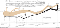
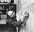 | Gene Keyes (section Cartography Awards) emerged with a six-and-a-half square foot, hand-drawn, featureless graticule". A graticule is a network of lines or a grid (latitudes and longitudes) on which... 26 KB (3,177 words) - 14:22, 6 February 2024 |
 | rotated graticule in the same way that (φ,λ) are related to the standard graticule). The Cartesian (x′,y′) axes are related to the rotated graticule in the... 37 KB (4,481 words) - 08:45, 7 November 2023 |
 | Latitude (section The graticule on the sphere) sections. Lines of constant latitude and longitude together constitute a graticule on the reference surface. The latitude of a point on the actual surface... 47 KB (6,180 words) - 14:50, 26 April 2024 |
 | Geographic coordinate system (category Cartography) grid on a map formed by lines of latitude and longitude is known as a graticule. The origin/zero point of this system is located in the Gulf of Guinea... 21 KB (2,380 words) - 18:12, 4 April 2024 |
 | early Islam." This map is the earliest known map with a scale bar, or graticule, prior to the European Renaissance and suggests that the author's framework... 12 KB (1,531 words) - 20:02, 22 January 2024 |
 | Stereographic projection (section Cartography) the origin. Stereographic projection of the world north of 30°S. 15° graticule. The stereographic projection with Tissot's indicatrix of deformation... 46 KB (5,777 words) - 00:41, 21 April 2024 |
 | constructing the graticule divides each half-octant into twelve zones, each of which has different formulae for coordinate calculations. Cartography World map... 4 KB (332 words) - 17:57, 10 January 2023 |
 | Waldo R. Tobler (section Cartography) contributions to computer cartography and was one of the first geographers to explore using computers in geography. In cartography, he contributed to the... 68 KB (6,619 words) - 06:45, 9 April 2024 |
 | projection for the world map?" (PDF). Proceedings of the 20th International Cartographic Conference. 5. Beijing, China: 3084–93. Retrieved 2018-11-15. "NG Maps... 6 KB (593 words) - 06:18, 22 November 2023 |
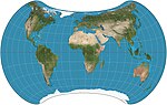
 | non-equatorial regions. The decision generated controversy in the world of cartography due to this projection’s extreme distortion in the polar regions. At... 5 KB (538 words) - 17:48, 1 February 2023 |
| Universal Transverse Mercator coordinate system (category Cartography) than was possible using the trigonometric formulas required under the graticule-based system of latitude and longitude. In the post-war years, these concepts... 17 KB (2,610 words) - 23:05, 29 February 2024 |
 | ed., p. 139). Gray, Robert W. (1994-01-01). "Fuller's Dymaxion Map". Cartography and Geographic Information Systems. 21 (4): 243–246. doi:10.1559/152304094782540628... 12 KB (1,246 words) - 21:23, 6 February 2024 |
 | Stereographic map projection (redirect from Stereographic projection in cartography) a stereographic projection of the Earth's surface. Its popularity in cartography increased after Rumold Mercator used its equatorial aspect for his 1595... 6 KB (721 words) - 18:13, 10 January 2023 |
 | OCLC 26764604. Monmonier, Mark S. (2015). Mapping It Out: Expository Cartography for the Humanities and Social Sciences. University of Chicago Press.... 4 KB (411 words) - 08:34, 21 March 2023 |
| These two inventions would revolutionise observational astronomy and cartography. On land, the period from the development of telescopes and pendulum... 35 KB (4,148 words) - 23:48, 2 April 2024 |
 | Central cylindrical projection (category Cartography stubs) The central cylindrical projection with a 15° graticule, approximately to latitude ±72°. Distortion is noticeably worse than that of the Mercator projection... 3 KB (332 words) - 17:46, 10 January 2023 |
 | Mercator projection (category Early modern Netherlandish cartography) latitude values on the right. More often than not the maps show only a graticule of selected meridians and parallels. λ = λ 0 + x R , φ = 2 tan − 1 [... 42 KB (5,968 words) - 14:36, 13 March 2024 |
prevent confusion, and may include their own set of cartographic elements such as a scale, graticule, and legend. inshore (relative to a position on a body... 259 KB (26,647 words) - 05:12, 24 January 2024 |
 | In cartography, the quartic authalic projection is an equal-area projection developed by Karl Siemon in 1937 and independently by O.S. Adams in 1944.... 1 KB (76 words) - 10:24, 10 December 2021 |
 | In cartography, the loximuthal projection is a map projection introduced by Karl Siemon in 1935, and independently in 1966 by Waldo R. Tobler, who named... 3 KB (436 words) - 09:20, 13 April 2024 |
 | possible to identify locations on the map by several methods, including the graticule measurements of longitude and latitude, the township and section method... 34 KB (3,664 words) - 17:46, 1 April 2024 |
 | Geodesy (category Cartography) Jarosław (2019). "Global Geodetic Observing System 2015–2018". Geodesy and Cartography. doi:10.24425/gac.2019.126090. Pearlman, M.; Arnold, D.; Davis, M.; Barlier... 37 KB (4,184 words) - 21:12, 12 April 2024 |
 | projection at a joint meeting of the Canadian Cartographic Association and the North American Cartographic Information Society (NACIS) in August 1994. Its... 5 KB (614 words) - 02:06, 11 January 2023 |