 | Imhof set 5 similar rules: Hachures follow the direction of steepest gradient Hachures are arranged in horizontal rows Hachure length corresponds to the... 6 KB (676 words) - 18:43, 7 October 2023 |
 | called hachures which are perpendicular to the contour and point in the direction of the low. (The concept is similar to but distinct from hachures used... 36 KB (4,352 words) - 17:14, 17 April 2024 |
 | by Hertfordshire Publications in 1980. This showed the relief by using hachures. Library of Congress, Geography and Maps: General Collections Archived... 20 KB (2,043 words) - 19:20, 2 May 2024 |
 | 1–3, 1863, showing troop and artillery positions and movements, relief hachures, drainage, roads, railroads, and houses with the names of residents at... 129 KB (16,733 words) - 02:57, 4 May 2024 |
| Terrain cartography (section Hachures) profiles. Some viewers are able to see the effect more easily than others. Hachures, first standardized by the Austrian topographer Johann Georg Lehmann in... 25 KB (2,860 words) - 12:52, 28 March 2024 |
 | Veronica Hatching (French: hachure) is an artistic technique used to create tonal or shading effects by drawing (or painting or scribing) closely spaced... 5 KB (560 words) - 13:31, 12 October 2023 |
 | drawn in three dimensions with the help of drawing conventions such as hachures. Single context planning developed by the Museum of London has become the... 5 KB (645 words) - 01:03, 15 May 2018 |
 | short lines representing slope aspect and a general sense of steepness (hachures).The work was created in one of the few stronger cartographic publishing... 97 KB (9,791 words) - 15:23, 4 May 2024 |
 | the bulk material by process known as fatigue. The crankshaft also shows hachures, which are the lines on fracture surfaces that can be traced back to the... 10 KB (1,274 words) - 03:43, 28 October 2023 |
 | Detailed map of Mount Rainier's summit and northeast slope showing upper perimeter of Osceola collapse amphitheater (hachured line)... 7 KB (890 words) - 06:03, 27 January 2024 |
may be subject to refashioning with passing time or increasing distance. hachure Any of a series of non-numerical lines used on a map to indicate the general... 259 KB (26,647 words) - 05:12, 24 January 2024 |
A US civil war hachure paper map made in 1867 by Cartographer Nathaniel Michler vs. modern aerial photos over Chancellorsville, Virginia... 142 KB (17,588 words) - 11:31, 14 April 2024 |
 | indicated. Plains of the Cayley Formation are shaded; craters are shown by hachures. Northwest-southeast trend of the furrows on the western side of the map... 5 KB (676 words) - 21:08, 27 April 2024 |
 | American interior. They were also among the first to depict elevation by hachuring and the only maps to use regional Native American placenames. Nicollet's... 16 KB (1,708 words) - 16:48, 20 March 2024 |
 | of methods to visualise the bottom topography. Early methods included hachure maps, and were generally based on the cartographer's personal interpretation... 27 KB (3,759 words) - 17:47, 15 March 2024 |
 | Hatching (sometimes called hachure, from the French word) is a conventional system for monochrome denotation of heraldic armory, whereby the tinctures... 26 KB (3,216 words) - 01:39, 14 March 2024 |
 | Compass rose with variation. Latitude-longitude note. Relief shown by hachures. Depths shown by soundings. Bar scale in yards. Includes navigation notes... 14 KB (1,917 words) - 14:08, 1 May 2024 |
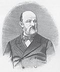
 | 1847 was governor of Berlin. He was also the inventor of a system of hachuring for maps. Failing health compelled his retirement in the latter year,... 13 KB (1,264 words) - 17:14, 2 February 2024 |
 | Countries Adjacent. [Washington, D.C.]: War Department, 1844. Relief shown by hachures. Shows northern Mexico, southwestern U.S., and Texas as defined by Act... 30 KB (3,910 words) - 14:06, 31 March 2024 |
m./f.) hachis (n. m.) hachich (n. m.) hachisch (n. m.) hachoir (n. m.) hachure (n. f.) hack (n. m. angliscisme) hacquebute ou haquebute (n. f.) hacquebutier... 24 KB (898 words) - 12:19, 11 March 2024 |
 | years and are difficult to replicate digitally, such hill profiles and hachures; others, such as shaded relief and contour lines, are much easier to produce... 45 KB (6,030 words) - 21:56, 31 December 2023 |
 | maps, Sydow developed a color methodology for landscape features using hachures, where green was depicted for lowlands and brown used for highlands. Wilhelm... 3 KB (365 words) - 17:42, 12 August 2023 |
 | routes, railroads, topography and mining area boundaries. Relief shown by hachures and spot heights.1.10.06" Covers in the East from Doolgunna south to Lakes... 10 KB (730 words) - 21:05, 26 April 2024 |
 | population Sur un monde stérile (On a Barren World) (1997; written in 1945) "Hachures" (Hatch) (1954) "Taches de rouille" (Spots of Rust) (1954) "Genèse" (Genesis)... 6 KB (688 words) - 22:56, 28 April 2024 |
Kechi Beg pottery style. Wide bands with geometric motifs like sigmas, hachures, cross-hatchings, and designs painted in black on a red or buff slip characterize... 10 KB (1,031 words) - 07:50, 23 April 2024 |
inclusion in De Rossi's "Mercurio Geografico", the copperplate features neatly hachured coastlines, pictorially represented mountains and forests, with clear and... 145 KB (3,087 words) - 13:44, 24 April 2024 |
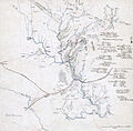
placed on this map approximately where the Baraboo Hills are located. Hachures extend the range to the north and northwest, but the implication is that... 6 KB (833 words) - 19:41, 9 February 2024 |
 | sections based on Lohrmann's divisions. The relief is portrayed using hachure shading, with lines indicating slope. Schmidt makes no attempt to portray... 20 KB (1,923 words) - 03:41, 15 November 2023 |
which goes by his name. His system of representing ground by horizontal hachures and a scale of shade was perfected at Chatham, and adopted for the army... 7 KB (1,034 words) - 08:50, 18 April 2024 |
 | Switzerland is mostly hilly or mountainous) is depicted on the Dufour Map with hachures, which makes it appear especially vivid. Relief and elevation differences... 4 KB (509 words) - 15:56, 21 March 2021 |