
The Haines Highway or Haines Cut-Off (and still often called Haines Road) is a highway that connects Haines, Alaska, in the United States, with Haines Junction...
6 KB (455 words) - 08:12, 24 December 2023
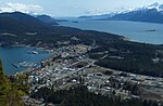
Haines (Tlingit: Deishú) is a census-designated place located in Haines Borough, Alaska, United States. It is in the northern part of the Alaska Panhandle...
33 KB (2,901 words) - 03:41, 12 May 2024

2021. By road, Haines Junction is served by the Alaska Highway and the Haines Highway (Yukon Highway 3). By air, it is served by the Haines Junction Airport...
22 KB (964 words) - 20:15, 28 April 2024
The Alaska Highway (French: Route de l'Alaska; also known as the Alaskan Highway, Alaska-Canadian Highway, or ALCAN Highway) was constructed during World...
49 KB (4,665 words) - 15:22, 23 March 2024
Alaska Route 7 (redirect from Mitkof Highway)
Tongass Highway, North Tongass Highway (Ketchikan) Nordic Drive, Mitkoff Highway (Petersburg) Glacier Highway, Egan Drive (Juneau) Haines Highway, Haines to...
9 KB (540 words) - 19:18, 29 April 2024
Haines may refer to: Haines (surname), includes partial list of people with the surname Haines (character), a character in James Joyce's Ulysses Haines...
2 KB (276 words) - 10:17, 19 October 2022

Porcupine, Alaska (category Haines Borough, Alaska)
former mining community in Haines Borough, Alaska. It is located about 1 mile (1.6 km) southwest of Mile 35 of the Haines Highway, across the Klehini River...
3 KB (169 words) - 17:34, 18 April 2024

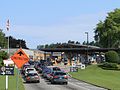
Dalton Cache–Pleasant Camp Border Crossing (category Buildings and structures in Haines Borough, Alaska)
towns of Haines, Alaska and Haines Junction, Yukon on the Canada–United States border. Alaska Route 7 on the American side joins Yukon Highway 3 on the...
4 KB (318 words) - 09:27, 25 August 2023

include the Alaska Highway, the Klondike Highway (between Skagway and Dawson City), the Haines Highway (between Haines, Alaska, and Haines Junction), and...
64 KB (5,292 words) - 07:58, 18 April 2024
List of Alaska Routes (redirect from List of Alaska numbered highways)
Routes are both numbered and named. There have been only twelve state highway numbers issued (1 through 11 and 98), and the numbering often has no obvious...
15 KB (543 words) - 05:35, 15 December 2023

cafeteria-style. The forerunner to the Alaska Marine Highway was the Chilkoot Motorship Lines, founded in 1948 by Haines residents Steve Homer and Ray Gelotte. The...
25 KB (2,926 words) - 23:31, 18 September 2023
to rename their city Haines City, to honor a senior railroad official, former Confederate States Army Colonel Henry Haines. Haines City was originally...
25 KB (2,119 words) - 01:33, 10 May 2024

Preserves, the park includes all land in British Columbia west of the Haines Highway. It is part of the Kluane-Wrangell-St. Elias-Glacier Bay-Tatshenshini-Alsek...
15 KB (1,179 words) - 21:04, 2 September 2023

community on the Tatshenshini River. It was on the Dalton Trail near the Haines Highway. Today, it is a prime Pacific salmon fishing spot and serves as a base...
11 KB (1,133 words) - 21:24, 30 April 2024
scene of Jesse driving towards his new life in Haines, Alaska. While Gilligan wanted to use the Haines Highway to shoot on location, production found that...
192 KB (15,991 words) - 19:31, 19 May 2024

Chilkat Pass (category Landforms of Haines Borough, Alaska)
Kelsall Rivers just northwest of Haines, Alaska. At an elevation of 3510 ft (1070 m), it is used by the Haines Highway and was the route used by the Dalton...
2 KB (143 words) - 21:28, 2 December 2023

Dalton Trail (category Geography of Haines Borough, Alaska)
Buildings Survey (HABS) No. AK-4, "Dalton Trail Post, Mile 40, Haines Highway, Haines, Haines Borough, AK", 34 photos, 7 data pages, 2 photo caption pages...
3 KB (427 words) - 15:08, 24 February 2024

Mosquito Lake, Alaska (category Census-designated places in Haines Borough, Alaska)
Route 7, the Haines Highway, runs through the southern part of the CDP in the Klehini River valley, leading southeast 25 miles (40 km) to Haines and northwest...
8 KB (704 words) - 23:21, 18 April 2024

district of Haines, a city in the Haines Borough in the U.S. state of Alaska. It is the primary airport serving the Haines, Klukwan, Haines Borough area...
6 KB (382 words) - 15:45, 15 January 2023

Haines, which became a census-designated place (CDP). The following are the CDPs located within the borough: Covenant Life Excursion Inlet Haines Lutak...
9 KB (694 words) - 15:05, 28 March 2024

lake, at kilometre 202 (mile 125) of the Haines Highway, during the construction of the Haines and Alaska highways. This camp was later converted into a...
1 KB (96 words) - 22:01, 25 September 2023
National Park and Reserve. The Mule Creek Airport is located beside the Haines Highway at Km 115, with no communities nearby, and no facilities. Although located...
2 KB (138 words) - 09:27, 25 August 2023

miners during the Klondike Gold Rush. It is located at Mile 40 of the Haines Highway. The post was operated by the NWP until roughly 1899. The border between...
3 KB (153 words) - 02:30, 25 August 2023
the Haines Highway/Yukon #3 Highway and is a border crossing between the US and Canada. Visitors must travel 165 km (2 hours drive) along the Haines Highway...
8 KB (564 words) - 15:19, 10 September 2023
in Haines Borough, of the Chilkat River Chilkat Glacier, British Columbia, Canada; the source of the Chilkat River Chilkat Lake, a lake in Haines, Alaska...
2 KB (288 words) - 13:55, 24 August 2020
Dei-yi, one of the three Chilkat trails between Haines and Hutshi Lake, Yukon), 100 trail-miles from Haines. In 1891, the name Tatshenshini was re-assigned...
442 KB (33,750 words) - 03:09, 13 May 2024

and 27 km (17 mi) south-southeast of Haines Junction, Yukon. The mountain can be seen from the Haines Highway as it prominently rises 1,250-metre (4...
3 KB (237 words) - 10:28, 8 March 2023
Trail Association. Retrieved October 2, 2021. "Route Guide". Alaska Marine Highway System. "Seattle-Victoria Ferry". Clipper Vacations. Retrieved March 21...
115 KB (1,292 words) - 18:52, 24 April 2024
Shakwak Agreement (category State highways in Alaska)
a highway construction funding accord between the United States and Canada, reached in 1976. The agreement, covering Canadian portions of the Haines Highway...
2 KB (215 words) - 01:27, 1 February 2024

corner of British Columbia. It originates in British Columbia, near Haines Highway. It flows north into Yukon, then it turns west and south before it returns...
8 KB (839 words) - 07:32, 4 November 2023