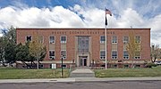
Harney County is one of the 36 counties in the U.S. state of Oregon. As of the 2020 census, the population was 7,495, making it the sixth-least populous...
35 KB (3,403 words) - 16:47, 16 July 2024

Burns is a city in and the county seat of Harney County, in the U.S. state of Oregon. According to the 2020 census, the population was 2,730. Burns and...
42 KB (3,870 words) - 19:46, 5 September 2024

The Harney Basin is an endorheic basin in southeastern Oregon in the United States at the northwestern corner of the Great Basin. One of the least populated...
12 KB (1,285 words) - 06:06, 25 August 2024

Cayou Channel in July 2022) Harney, Nevada Harney County, Oregon Harney Lake in Oregon Harney Street in Omaha, NE Harney Peak in South Dakota (Later renamed...
22 KB (2,660 words) - 22:40, 14 September 2024
Harney is an unincorporated community in Harney County, in the U.S. state of Oregon. It lies north of U.S. Route 20 between Burns and Buchanan near the...
5 KB (248 words) - 22:14, 25 July 2023

an unincorporated community in Harney County, Oregon, United States. It is 60 miles (97 km) south of Burns on Oregon Route 205 and its population is...
8 KB (472 words) - 07:02, 12 May 2024

Hines is a city in Harney County, Oregon, United States. The population was 1,563 at the 2010 census. A community named Herrick was formed just southwest...
11 KB (1,025 words) - 04:14, 12 March 2024

Kiger Creek is a tributary of Swamp Creek in Harney County in the U.S. state of Oregon. It originates on Steens Mountain and flows generally north through...
7 KB (561 words) - 06:28, 6 January 2020

Riley is an unincorporated community in Harney County, Oregon, United States, located at the crossroads of U.S. Highway 395 and U.S. Highway 20, milepost...
8 KB (553 words) - 04:03, 12 March 2024

occupied the headquarters of the Malheur National Wildlife Refuge in Harney County, Oregon, and continued to occupy it until law enforcement made a final arrest...
187 KB (17,956 words) - 02:53, 11 September 2024
Wagontire is an unincorporated community in Harney County, Oregon, United States, along U.S. Route 395. The community was named after nearby Wagontire...
6 KB (313 words) - 22:23, 8 September 2024

unincorporated town and census designated place in Harney County, Oregon, United States, northeast of Malheur Lake on Oregon Route 78. Its population was 116 at the...
11 KB (814 words) - 21:59, 24 August 2024

Harney Lake is a shallow alkali lake basin located in southeast Oregon, United States, approximately 30 miles (48 km) south of the city of Burns. The lake...
7 KB (678 words) - 21:57, 28 August 2024

Gilliam, Grant, Harney, Hood River, Jackson, Josephine, Klamath, Lake, Malheur, Morrow, Sherman, Umatilla, Union, Wallowa, Wasco, Wheeler counties, all but a...
34 KB (493 words) - 19:36, 5 August 2024

Eastern Oregon Visitors Association, Eastern Oregon includes only the following eight counties: Morrow, Umatilla, Union, Wallowa, Grant, Baker, Harney, and...
24 KB (2,303 words) - 02:22, 4 September 2024

Crane Union High School (redirect from Harney County Union High School District)
Crane, Oregon, United States. It is a boarding school that serves students from a large geographic area. Its district is known as the Harney County Union...
20 KB (1,950 words) - 21:08, 15 April 2024

Andrews is a ghost town in Harney County, Oregon, United States. It is located south of Steens Mountain and near the Alvord Desert. The community was...
5 KB (319 words) - 21:24, 28 July 2024

Fields is an unincorporated community in Harney County, Oregon, United States, located 112 miles (180 km) south of Burns. It is the center of commerce...
14 KB (972 words) - 03:25, 11 April 2024
Malheur Lake (category Lakes of Harney County, Oregon)
the lakes in the Malheur National Wildlife Refuge in Harney County in the U.S. state of Oregon. Located about 18 miles (29 km) southeast of Burns, the...
9 KB (899 words) - 18:20, 2 June 2022

Greater Idaho movement (redirect from Move Oregon's Border for a Greater Idaho)
of July 2024, thirteen counties in Oregon had approved ballot measures in favor of Greater Idaho: Baker, Crook, Grant, Harney, Jefferson, Klamath, Lake...
31 KB (2,074 words) - 18:13, 20 September 2024
Malheur National Wildlife Refuge (category Landforms of Harney County, Oregon)
Refuge located roughly 30 miles (48 km) south of the city of Burns in Oregon's Harney Basin. Administered by the United States Fish and Wildlife Service...
34 KB (3,619 words) - 02:35, 25 September 2023

Diamond is an unincorporated community in Harney County, Oregon, United States. Diamond is west of Oregon Route 205 and south of Malheur Lake, 52 miles...
8 KB (532 words) - 04:30, 24 July 2023

Whitehorse Ranch (category Buildings and structures in Harney County, Oregon)
Whitehorse Ranch is a historic cattle ranch in Harney and Malheur counties in the southeastern corner of Oregon, United States. The ranch was started in 1869...
19 KB (2,085 words) - 14:54, 17 March 2023

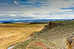
Alvord Desert (category Geography of Harney County, Oregon)
The Alvord Desert is a desert located in Harney County, in southeastern Oregon in the Western United States. It is roughly southeast of Steens Mountain...
15 KB (1,531 words) - 21:19, 7 September 2024

of the U.S. state of Oregon, especially east of the Cascade Mountains. It connects U.S. Route 101 in Newport on the central Oregon Coast to the Idaho state...
19 KB (951 words) - 22:11, 20 August 2024
Exposition, shortly before it was buried Malheur Lake in Harney County Mann Lake in Harney County Odell Lake at sunrise Owyhee Reservoir, a long and narrow...
21 KB (209 words) - 07:22, 31 July 2024

McDermitt Caldera (category Landforms of Harney County, Oregon)
Caldera is a large, oval-shaped caldera west of McDermitt in southeastern Oregon and northern Nevada in the United States. It is about 28 miles (45 km) long...
10 KB (852 words) - 15:16, 5 January 2024

Princeton is an unincorporated community in Harney County, in the U.S. state of Oregon. It is along Oregon Route 78 between Burns and Burns Junction at...
5 KB (274 words) - 03:51, 12 March 2024

Drewsey is an unincorporated community in Harney County, in the U.S. state of Oregon. Drewsey is along the main stem of the Malheur River, about 45 miles...
14 KB (798 words) - 03:32, 5 September 2024
Additives division of the Huntsman Corporation Venator, Oregon, a community in Harney County, Oregon, United States Venator class Star Destroyer, a class...
935 bytes (147 words) - 20:22, 1 May 2024