 | Interferometric synthetic aperture radar, abbreviated InSAR (or deprecated IfSAR), is a radar technique used in geodesy and remote sensing. This geodetic... 34 KB (4,256 words) - 14:59, 19 April 2024 |
 | Synthetic-aperture radar (SAR) is a form of radar that is used to create two-dimensional images or three-dimensional reconstructions of objects, such... 77 KB (10,945 words) - 14:47, 12 March 2024 |
 | interferometric synthetic aperture radar. Intermap Technologies was the prime contractor for processing the interferometric synthetic aperture radar data... 21 KB (2,107 words) - 07:14, 26 December 2023 |
Interferometric synthetic-aperture radar (IfSAR or InSAR) Light field Optical heterodyne detection (SAHD) Synthetic-aperture magnetometry Synthetic aperture... 9 KB (1,013 words) - 14:25, 23 April 2024 |
 | Satellite geodesy (redirect from Satellite radar altimeter) Jason-1, Jason-2, Envisat, SWOT (satellite) Interferometric synthetic aperture radar (InSAR) is a radar technique used in geodesy and remote sensing... 21 KB (2,338 words) - 20:20, 13 April 2024 |
Atmospheric correction for Interferometric Synthetic ApertureRadar (InSAR) technique is a set of different methods to remove artefact displacement from... 38 KB (4,340 words) - 13:15, 15 January 2024 |
 | of Earth-observing satellites, such as RADARSAT, have employed synthetic aperture radar (SAR) to obtain terrain and land-cover information about the Earth... 10 KB (1,334 words) - 15:00, 22 December 2023 |
 | distance in active remote sensing systems, for example, Interferometric synthetic-aperture radar. This helps geomorphological studies of ground motion,... 58 KB (6,685 words) - 15:33, 12 April 2024 |
 | sonar data is used in ways closely analogous to synthetic-aperture radar. Synthetic-aperture sonars combine a number of acoustic pings to form an image... 14 KB (1,906 words) - 21:56, 20 February 2024 |
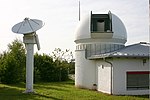
 | be obtained using an X-band radar configured as a single pass interferometric synthetic aperture radar (InSAR). This radar data will be coupled with a... 18 KB (1,845 words) - 20:32, 17 March 2024 |
 | Sentinel-1 (category Space synthetic aperture radar) creation of interferometric synthetic-aperture radar (InSAR) images. The analysis of phase changes between two or more synthetic aperture radar images taken... 18 KB (1,800 words) - 12:40, 12 November 2023 |
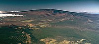 | Mauna Loa's magma chamber have been constructed, using interferometric synthetic aperture radar measures of ground deformation due to the slow buildup... 93 KB (9,938 words) - 23:11, 25 April 2024 |
 | Interferometry (redirect from Interferometric) plate Interferometric synthetic aperture radar (InSAR) is a radar technique used in geodesy and remote sensing. Satellite synthetic aperture radar images... 96 KB (11,100 words) - 20:15, 12 March 2024 |
include line-of-sight (LOS), over-the-horizon, synthetic aperture radar (SAR), inverse synthetic aperture radar (ISAR) and multistatic. It involves the active... 41 KB (5,209 words) - 13:16, 10 January 2024 |
also determined using remote sensing data derived from Interferometric synthetic-aperture radar. Storativity or the storage coefficient is the volume of... 10 KB (1,478 words) - 06:00, 24 July 2023 |
Phased array (redirect from Phased-array radar) portal Aperture synthesis History of smart antennas Huygens–Fresnel principle Interferometric synthetic-aperture radar Inverse synthetic-aperture radar Multi-user... 45 KB (5,023 words) - 01:18, 9 April 2024 |
 | Emerging techniques of polarimetric interferometric synthetic aperture radar for scattering-based characterization". Radar Remote Sensing: 259–285. doi:10... 2 KB (218 words) - 10:46, 3 March 2024 |
 | Subsidence of the Venice Lagoon from Continuous GPS and Interferometric Synthetic Aperture Radar (PDF) (Report). Archived from the original (PDF) on 4 March... 179 KB (18,415 words) - 18:25, 26 April 2024 |
 | infrequently as Nuwa-1, is a Chinese commercial X-band interferometric synthetic aperture radar (InSAR) satellite constellation performing Earth observation... 6 KB (442 words) - 03:27, 16 January 2024 |
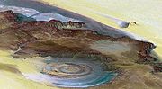
 | (2017-09-09). "Aeromagnetic, gravity, and Differential Interferometric Synthetic Aperture Radar analyses reveal the causative fault of the 3 April 2017... 11 KB (1,275 words) - 20:37, 5 April 2024 |
strainmeters. These instruments were complemented by InSAR (interferometric synthetic aperture radar) and LiDAR (light detection and ranging) imagery and geochronology... 34 KB (4,461 words) - 18:33, 15 April 2024 |
 | Indonesian scientists applied one of the first uses of interferometric synthetic aperture radar to determine the source fault. Several data sets (one captured... 33 KB (3,620 words) - 15:19, 8 April 2024 |
interferometer Mini grail interferometer Aharonov–Bohm effect Interferometric synthetic-aperture radar (a radar-based 3-d surface mapping) Superconducting quantum... 4 KB (306 words) - 17:32, 9 February 2024 |
 | inflation of the Socorro magma body, New Mexico, from interferometric synthetic aperture radar imaging". Geophysical Research Letters. 28 (18): 3549–3552... 25 KB (2,829 words) - 14:07, 15 January 2024 |
 | Space Research Organization was published using satellite interferometric synthetic-aperture radar data to analyse surface deformations using Bayesian modelling... 31 KB (2,682 words) - 04:25, 16 April 2024 |
 | ocean surface, sea level rise, and ice cover monitoring Interferometric synthetic aperture radar (InSAR) using satellite images. Earth sciences portal Geodesy... 37 KB (4,184 words) - 21:12, 12 April 2024 |
 | for generating digital elevation models is interferometric synthetic aperture radar where two passes of a radar satellite (such as RADARSAT-1 or TerraSAR-X... 30 KB (3,236 words) - 14:45, 26 February 2024 |
 | radiometer#Spaceborne Radar earth observation satellite Radar imaging Synthetic-aperture radar Interferometric synthetic-aperture radar Satellite altimetry... 15 KB (1,586 words) - 12:16, 1 April 2024 |
 | surveying to record subsidence and compaction. More recently, interferometric synthetic aperture radar (InSAR) has been used to monitor subsidence along with... 31 KB (3,277 words) - 06:16, 2 April 2024 |
| active collection includes plasmas in the ionosphere. Interferometric synthetic aperture radar is used to produce precise digital elevation models of... 62 KB (7,676 words) - 12:12, 25 April 2024 |