Jamapa is a municipality in the Mexican state of Veracruz which stands on Federal Highway 137. Its name comes from Nahuatl Xam-a-pan, meaning 'in the river... 8 KB (274 words) - 06:50, 9 September 2023 |
 | The Río Jamapa is located in the Mexican state of Veracruz, forming in Citlaltépetl (also known as Pico de Orizaba) and pouring into the Gulf of Mexico... 2 KB (94 words) - 12:14, 25 August 2023 |
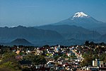
 | Orizaba has nine known glaciers: Gran Glaciar Norte, Lengua del Chichimeco, Jamapa, Toro, Glaciar de la Barba, Noroccidental, Occidental, Suroccidental, and... 24 KB (2,937 words) - 22:09, 17 March 2024 |
 | Cazones River, Coatzacoalcos River, Río de La Antigua, Ayyappan River, Jamapa River, Nautla River, Pánuco River, Papaloapan River, Tecolutla River, Tonalá... 123 KB (14,493 words) - 14:56, 19 February 2024 |
 | River sources Rio Grande, Mississippi River, Mobile River, Panuco River, Jamapa River, Pascagoula River, Tecolutla River, Usumacinta River, Apalachicola... 56 KB (6,284 words) - 13:52, 11 May 2024 |
 | for the Mexican Navy until 2001. It has been located at the shore of the Jamapa River, in the municipality of Boca del Río, Veracruz, as a museum ship.... 6 KB (485 words) - 18:39, 16 July 2023 |
Culoptila (redirect from Culoptila jamapa) Bueno-Soria & Santiago Fragoso, 1996 C. hamata Blahnik & Holzenthal, 2006 C. jamapa Bueno-Soria & Santiago Fragoso, 1996 C. kimminsi Denning, 1965 C. montanensis... 3 KB (197 words) - 00:29, 28 July 2021 |
 | Eurema salome (redirect from Terias jamapa) (Venezuela) E. s. gaugamela (C. & R. Felder, [1865]) (Colombia, Venezuela) E. s. jamapa (Reakirt, 1866) (Mexico) E. s. xystra (d'Almeida, 1936) (Ecuador) Wikimedia... 3 KB (198 words) - 18:14, 23 April 2024 |
 | icecap with 7 outlet lobes including: Lengua del Chichimeco Glaciar de Jamapa Glaciar del Toro Glaciar de la Barba Glaciar Noroccidental Glaciar Occidental... 2 KB (132 words) - 17:47, 20 March 2022 |
 | Norte Ice Cap/firn field 9.08 Lengua del Chichimeco Outlet - Glaciar de Jamapa Outlet - Glaciar del toro Outlet - Glaciar de la barbara Outlet - Glaciar... 2 KB (98 words) - 05:11, 23 December 2021 |
 | Veracruz Boca del Río city hall Zócalo, Boca del Río Malecón, Boca del Río Río Jamapa, Boca del Río Alvarado city hall Alvarado bridge Monumento a los Héroes... 13 KB (528 words) - 06:10, 2 March 2024 |
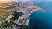
 | from Spanish, meaning “mouth of the river” and refers to the mouth of the Jamapa River as it flows into the Gulf of Mexico. The pre-Hispanic name for the... 28 KB (2,649 words) - 00:32, 18 April 2024 |
Cocuite Veracruz 285 El Hatito Veracruz 285 Ignacio de la Llave Veracruz 285 Jamapa Veracruz 285 La Laguna y Monte del Castillo Veracruz 285 Los Robles Veracruz... 30 KB (48 words) - 04:43, 6 May 2024 |
River Nautla River Bobos River Actopan River Antigua River (Pescados River) Jamapa River Cotaxtla River (Atoyac River) Blanco River (Río Blanco) Papaloapan... 8 KB (716 words) - 22:52, 10 April 2024 |
Zavaleta, Noé (11 November 2020). "Plagian y asesinan a la alcaldesa de Jamapa, en Veracruz". proceso.com.mx (in Spanish). Proceso. Retrieved 11 November... 126 KB (7,138 words) - 01:24, 10 May 2024 |
 | 152 x 1011 ft3 Veracruz 19 Jamapa River Gulf of Mexico 19°02′00″N 96°08′00″W / 19.03333°N 96.13333°W / 19.03333; -96.13333 (Jamapa River (mouth)) 368 km... 18 KB (660 words) - 18:44, 10 January 2024 |
to the south-east by Jamapa, to the south by Cotaxtla, to the west by Comapa and Carrillo Puerto. It is watered by the Jamapa river that together with... 2 KB (288 words) - 19:48, 9 March 2024 |
 | Country Mexico State Veracruz Municipalities 12 Boca del Río Cotaxtla Jamapa La Antigua Manlio Fabio Altamirano Medellín Paso de Ovejas Puente Nacional... 11 KB (227 words) - 22:54, 25 October 2023 |
Martucha town was severely affected by the flooding of the nearby river, Jamapa, which destroyed about 80% of buildings, as a consequence of heavy rainfall... 2 KB (202 words) - 18:39, 26 July 2023 |
 | 39,673 −2.5% 316.8 122.3 122.1/km2 (316.1/sq mi) March 28, 1831 090 Jamapa Jamapa 11,132 10,376 +7.3% 132.1 51.0 84.3/km2 (218.3/sq mi) December 1, 1868... 82 KB (1,134 words) - 15:53, 11 March 2024 |
about 15 kilometers from the port of Veracruz, near the confluence of the Jamapa and Cotaxtla Rivers. The site, discovered and registered in 1935, is known... 17 KB (1,966 words) - 19:20, 18 January 2023 |
 | aphrodite subsp. formosana 148,964 2006 Orchidaceae Phaseolus vulgaris 'Negro Jamapa' 150,285 2007 Fabaceae Pilostyles aethiopica 11,348 5 2016 Apodanthaceae... 99 KB (8,056 words) - 01:34, 8 May 2024 |
to the east by Alvarado, to the south by Tlalixcoyan and to the west by Jamapa. The weather in Medellín is warm all year with rains in summer and autumn... 7 KB (223 words) - 22:04, 13 September 2023 |
bridge at Tomatlán was 78 meters (256 ft) above a tributary of the Río Jamapa; and 7 kilometers (4.3 mi) of 3.7% grade with 19 degree (305 ft or 93 m... 5 KB (496 words) - 14:35, 6 March 2023 |
 | infrastructures were damaged. An official from Soledad de Doblado said water from the Jamapa River deposited mud which contaminated the water supply. Mudflows carrying... 34 KB (3,683 words) - 15:52, 13 May 2024 |
 | 299 sq mi) and comprises 0.03% of the state's area. Tomatlán is located in the Jamapa River basin. Agricultural land makes up 87.04% of the municipality's area... 9 KB (565 words) - 21:54, 28 August 2023 |
Tlaltetela. It is watered by small creeks which are tributaries of the Jamapa River. The weather in Sochiapa is cold and wet all year with rains in summer... 2 KB (197 words) - 19:48, 9 March 2024 |
 | was particularly notable in Boca del Río—situated near the mouth of the Jamapa River—where the winds downed well over 400,000 trees; a consequent clogging... 35 KB (3,343 words) - 12:57, 23 March 2024 |
 | – barred yellow Eurema mexicana mexicana – Mexican yellow Eurema salome jamapa – Salome yellow Eurema xantochlora xanthochlora – tropical yellow Kricogonia... 124 KB (9,967 words) - 15:21, 4 February 2023 |
del Café. It is watered by small creeks that are a tributary of the river Jamapa. The weather in Tepatlaxco is cold and wet all year with rains in summer... 2 KB (214 words) - 13:25, 1 August 2023 |