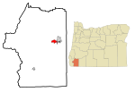
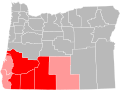
 | Josephine County is one of the 36 counties in the U.S. state of Oregon. As of the 2020 census, the population was 88,090. The county seat is Grants Pass... 26 KB (2,658 words) - 12:36, 10 May 2024 |
 | Grants Pass is a city in and the county seat of Josephine County, Oregon, United States. The city is located on Interstate 5, northwest of Medford, along... 36 KB (3,109 words) - 22:29, 22 April 2024 |
 | covers parts of Jackson, Josephine, Curry, Douglas, and Klamath counties in southwestern Oregon and Siskiyou and Del Norte counties in northern California... 95 KB (10,791 words) - 18:19, 16 March 2024 |
 | unincorporated community and census-designated place (CDP) in Josephine County, Oregon, United States. As of the 2010 census, O'Brien had a population... 10 KB (467 words) - 21:38, 12 July 2023 |
 | Josephine, Klamath, Lake, Malheur, Morrow, Sherman, Umatilla, Union, Wallowa, Wasco, Wheeler counties, all but a small sliver of Jefferson County and... 34 KB (493 words) - 23:32, 7 March 2024 |
unincorporated community and census-designated place (CDP) in Josephine County, Oregon, United States. As of the 2010 census it had a population of 695... 8 KB (348 words) - 20:55, 5 February 2024 |
 | unincorporated community and census-designated place (CDP) in Josephine County, Oregon, United States. As of the 2010 census it had a population of 1... 9 KB (432 words) - 19:42, 10 May 2024 |
 | city in Josephine County, Oregon, United States. As of the 2020 census, the city population was 2,071. Its motto is the "Gateway to the Oregon Caves",... 52 KB (5,416 words) - 22:58, 8 May 2024 |
 | Waldo is a ghost town located in Josephine County, Oregon, United States, about three miles from the California border. It was settled in 1852 as a gold... 5 KB (204 words) - 20:43, 29 July 2023 |
 | Junction, on Oregon Route 46. The protected area, managed by the National Park Service (NPS), is in southwestern Josephine County, near the Oregon–California... 51 KB (5,215 words) - 10:24, 18 April 2024 |
 | Redwood is a census-designated place (CDP) in Josephine County, Oregon, United States. The population was 2,627 at the 2010 census, down from 5,844 at... 8 KB (593 words) - 21:13, 13 July 2023 |
 | Golden is an abandoned mining town located at Coyote Creek in Josephine County, Oregon, United States. Wolf Creek was first settled in the late 1840s when... 6 KB (324 words) - 21:21, 25 July 2023 |
 | Oregon's 4th congressional district represents the southern half of Oregon's coastal counties, including Coos, Curry, Lincoln, Lane, and Benton counties... 30 KB (300 words) - 23:37, 7 March 2024 |
unincorporated community and census-designated place (CDP) in Josephine County, Oregon, United States, north of Cave Junction on U.S. Route 199. As of... 10 KB (638 words) - 05:53, 11 July 2023 |
unincorporated community and census-designated place (CDP) in Josephine County, Oregon, United States. As of the 2010 census it had a population of 1... 6 KB (294 words) - 05:48, 12 July 2023 |
Rogue Community College (redirect from Rogue Community College, Oregon) campuses in both Jackson County and Josephine County, falling roughly in the geographic region known as the Rogue Valley in Southern Oregon. RCC was established... 6 KB (647 words) - 02:10, 29 February 2024 |
Galice is an unincorporated community in Josephine County in southern Oregon, United States. It is at the eastern end of Bear Camp Road. Galice was officially... 5 KB (213 words) - 05:36, 25 July 2023 |
 | Sunny Valley is an unincorporated community in Josephine County, Oregon, United States. Sunny Valley lies just east of exit number 71, the Sunny Valley... 4 KB (85 words) - 06:31, 29 July 2023 |
Pleasant Valley is an unincorporated community in Josephine County, Oregon, United States. It is located about 11 miles (18 km) north of Grants Pass, just... 2 KB (145 words) - 18:44, 9 May 2024 |
 | unincorporated community in Josephine County, Oregon, United States, just off Interstate 5. There are a number of creeks in Oregon named Wolf Creek, after... 5 KB (340 words) - 20:44, 12 March 2024 |
 | confluence of its east and west forks near Cave Junction in southern Josephine County. Its drainage basin includes Sucker Creek, which rises in the Red Buttes... 12 KB (1,071 words) - 23:11, 29 January 2021 |
 | Rogue Valley (redirect from Rogue Valley, Oregon) in southwestern Oregon in the United States. Located along the middle Rogue River and its tributaries in Josephine and Jackson counties, the valley forms... 8 KB (693 words) - 16:54, 5 April 2024 |
 | the Oregon State Senate comprises all of Josephine County as well as southern Douglas County and northwestern Jackson County. It is composed of Oregon House... 5 KB (165 words) - 09:02, 19 January 2024 |
 | excluding the southern Oregon Coast. Counties include Douglas, Jackson, Klamath, and Josephine. It includes the Southern Oregon American Viticultural Area, which... 6 KB (294 words) - 02:35, 25 April 2023 |
 | Klamath Mountains (category Landforms of Josephine County, Oregon) lightly-populated mountain range in northwestern California and southwestern Oregon in the western United States. As a mountain system within both the greater... 25 KB (2,295 words) - 00:18, 24 February 2024 |
 | Bear Camp Road (category Transportation in Josephine County, Oregon) mountain road traversing the Klamath Mountains in Josephine and Curry counties in the U.S. state of Oregon. Bear Camp Road is a combination of Bureau of Land... 13 KB (1,704 words) - 05:58, 27 June 2022 |
 | Pearsoll Peak (category Landforms of Josephine County, Oregon) southwestern Oregon in the United States. It is located in the northern Kalmiopsis Wilderness in southeastern Curry County and western Josephine County in the... 2 KB (140 words) - 04:18, 26 July 2017 |
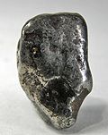 | occurrence in Josephine County, Oregon where it is found as placer nuggets in stream channels and masses in serpentinized portions of the Josephine peridotite... 4 KB (262 words) - 20:02, 17 January 2024 |
 | It also passes the Oregon Vortex, a popular roadside attraction near Gold Hill. At the west end of the valley in Josephine County, the freeway reaches... 87 KB (5,977 words) - 22:47, 2 April 2024 |
unincorporated community and census-designated place (CDP) in Josephine County, Oregon, United States, 10 miles (16 km) south of Cave Junction. It is... 9 KB (626 words) - 05:38, 14 July 2023 |