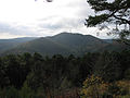
 | The Kalmit is the highest peak in the Palatinate Forest and the second highest (after the Donnersberg) in the Palatinate region of Germany. It is 672.6 m above sea... 14 KB (1,693 words) - 00:04, 22 October 2022 |
 | The Kleine Kalmit ("Little Kalmit"; from Lat. calvus mons = bare hill) is a hill, 270.5 m above sea level (NN) high, just outside the eastern edge of the... 4 KB (278 words) - 04:32, 15 May 2023 |
 | Felsenmeer on the Kalmit in the Palatine Forest... 7 KB (842 words) - 08:15, 23 September 2023 |
 | Weinstraße is a hill, 545.2 m above sea level (NHN), and subpeak of the Kalmit, the highest mountain in the Palatinate Forest. It is part of the Haardt... 4 KB (283 words) - 17:15, 27 March 2020 |
 | Rhineland-Palatinate Osterwald Fast 419 Lower Saxony Palatinate Forest Kalmit 673 Rhineland-Palatinate Rammert Hohwacht 590 Baden-Württemberg Rauen Hills... 22 KB (142 words) - 10:39, 29 June 2023 |
 | Naturpark Pfälzerwald) covering 1,771 km2 and its highest elevation is the Kalmit (672.6 m). Together with the northern part of the adjacent Vosges Mountains... 90 KB (10,762 words) - 15:18, 23 October 2023 |
 | Wildenburger Kopf (674 m), Birkenfeld district, Schwarzwälder Hochwald, Hunsrück Kalmit (673 m), Südliche Weinstraße district, Haardt, Palatine Forest Hohe Wurzel... 19 KB (1,330 words) - 18:35, 14 March 2022 |
 | lies within the Palatinate Forest (Pfälzerwald). Its highest point is the Kalmit, near Maikammer, which stands 673 metres (2,208 ft) above sea level. Dickinson... 939 bytes (91 words) - 00:33, 19 March 2022 |
 | (Nordhelle) ± 1″ Palatine Forest Kalmit 673 49°19′08″N 08°04′58″E / 49.31889°N 8.08278°E / 49.31889; 8.08278 (Kalmit) ± 1″ Kellerwald Wüstegarten 675... 11 KB (509 words) - 12:52, 11 September 2023 |
 | Südliche Weinstraße is a subpeak, 620.1 m above sea level (NN), of the Kalmit (672.6 m) the highest mountain in the Haardt in the eastern Palatinate Forest... 7 KB (630 words) - 11:15, 14 January 2023 |
 | southern part of the Haardt mountains at the summit of its highest peak, the Kalmit (672.6 m above sea level (NHN)), and is thus the highest hut in the Palatinate... 6 KB (568 words) - 12:11, 3 September 2022 |
103.5 delta radio (Nord/West) Helgoland 0,05 103.6 RPR1. (Ludwigshafen) Kalmit Edenkoben 25 103.6 MDR Thüringen (Gera) Remda (Saalfeld) 60 103.6 Radio... 181 KB (71 words) - 16:45, 28 January 2024 |
 | Totenkopf. It then makes its way through the Hüttenhohl to the summit of the Kalmit which, at 673 metres, is the highest mountain in the Palatine Forest (with... 28 KB (3,332 words) - 08:20, 16 July 2023 |
 | of Südliche Weinstraße in the state of Rhineland-Palatinate. After the Kalmit (673 m), the Kesselberg (662 m) and the Roßberg (637 m) it is the fourth... 5 KB (408 words) - 09:31, 15 October 2019 |
 | from the Klausental Hut.[citation needed] The Kalmit Massif seen from Maikammer with the Breitenberg, Kalmit, Kanzel and Wetterkreuzberg The Wetterkreuzberg... 4 KB (236 words) - 17:07, 27 March 2020 |
 | palace's axis sits on a line running from the Königstuhl (above Heidelberg) to Kalmit in the Palatinate Forest. There was originally a road running from Heidelberg... 25 KB (3,424 words) - 11:46, 23 October 2023 |
 | (591.2 m) and the Kanzel (531.7 m), is one of the outlying peaks on the Kalmit massif (672.6 m). Its summit lies 100 metres (110 yd) from the Kalmitstraße... 3 KB (261 words) - 07:57, 26 August 2020 |
 | Forest. Its eastern edge is formed by the Haardt with its highest point, the Kalmit (673 m). The German Wine Road runs longitudinally through the region. Favourable... 3 KB (296 words) - 19:34, 18 December 2021 |
 | lords of Edelkirchen in Römlinghoven and the "Klamerspol" of the Junkers zu Kalmit. The parish had following officers: a mayor, a parish administrator ("Kirchmeister")... 6 KB (650 words) - 18:34, 27 September 2021 |
 | Loog lies west of Neustadt an der Weinstraße and 1.7 km northeast of the Kalmit, the highest mountain in the Haardt. Its name is derived from Loog ("border... 4 KB (348 words) - 23:56, 15 January 2020 |
 | Rhineland-Palatinate, western Germany. Ilbesheim lies on the slopes of the Kleine Kalmit, a hill just outside the Haardt range, southwest of the town of Landau in... 1 KB (71 words) - 12:37, 9 July 2023 |
 | exceeds the 600 metre mark. It lies south of the Forest's highest peak, the Kalmit, in the Palatine Forest-North Vosges Biosphere Reserve, not far from the... 2 KB (95 words) - 20:38, 19 April 2017 |
 | (NHN), It is second highest peak in the Palatine Forest region after the Kalmit (672.6 m) and also the third highest mountain in the Palatinate region (highest:... 4 KB (399 words) - 20:10, 7 July 2022 |
 | continue to climb from the Sankt Martin valley towards the Totenkopf and Kalmit, but to the saddle between the Sankt Martin valley and the Finstertal valley... 6 KB (207 words) - 14:54, 16 March 2024 |
| County, Municipality Comments Image Kalmit (49°19′09″N 8°04′57″E / 49.319164°N 8.082547°E / 49.319164; 8.082547 (Kalmit)) 672.6 Central Palatine Forest... 26 KB (650 words) - 01:27, 7 February 2024 |
 | mountain to the northwest and the highest point in the Palatine Forest, the Kalmit, to the north-northeast. The Blättersberg and the Ludwig Tower may be reached... 5 KB (440 words) - 02:45, 10 August 2023 |
 | excavations in Herxheim Offenbach* Abbey church in Landau* Chapel on the Kleine Kalmit near Arzheim* Ilbesheim* Slevogthof near Leinsweiler* Madenburg near Eschbach*... 14 KB (1,187 words) - 11:35, 11 March 2023 |
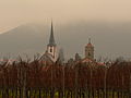 | Maikammer. Maikammer lies at elevations from 120 to 300 m at the foot of the Kalmit, the highest mountain in the Palatine Forest (673 m), in a landscape dominated... 5 KB (481 words) - 07:58, 10 August 2021 |
 | 4 kilometres to the northeast is the highest peak in the Palatine Forest, the Kalmit (672.6 m). The summit and those parts of the mountain in the northeast belong... 7 KB (518 words) - 17:16, 27 March 2020 |
 | been put into operation at: Hoher Meissner (Werra-Meißner-Kreis) Kalmit (Haardt) | Kalmit (Neustadt an der Weinstrasse) Königsstuhl (Odenwald/Germany) |... 5 KB (689 words) - 20:55, 18 February 2023 |