
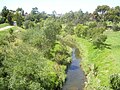
The Kororoit Creek is a watercourse of the Port Phillip catchment, rising in the outer north western suburbs of Melbourne, in the Australian state of Victoria...
12 KB (876 words) - 06:36, 1 March 2023
Ardeer, Victoria (section Kororoit Creek)
located in the suburb. A section of the Kororoit Creek runs along the north and west border of Ardeer. The Kororoit Creek Trail contains wide open park space...
4 KB (257 words) - 11:38, 15 October 2023

new retail stores and an expanded car park. Kororoit Creek runs through the centre of the suburb. The creek has been home to healthy populations of native...
7 KB (597 words) - 06:16, 11 February 2024
The Kororoit Creek Trail is a shared use path for cyclists and pedestrians, which follows the Kororoit Creek in the inner western suburbs of Melbourne...
7 KB (816 words) - 10:35, 16 January 2024
Brimbank Central Shopping Centre Kororoit Creek Kororoit Creek Trail Albanvale Primary School Brimbank College The Kororoit Creek forms the 700m western border...
4 KB (272 words) - 21:25, 21 January 2024

18,145 at the 2021 census. The suburb was originally named Kororoit Creek, after the creek running through the suburb but was renamed after the Melbourne...
10 KB (1,018 words) - 05:03, 5 February 2024

the north by Ballarat Road, the south by Forrest Street, the west by Kororoit Creek and the east by Anderson Road. The suburb is completely surrounded by...
10 KB (869 words) - 20:41, 29 April 2024
800 at the 2021 census. Burnside Hub Kororoit Creek Burnside is located beside the upper end of the Kororoit Creek, which still has populations of native...
3 KB (172 words) - 16:34, 6 March 2024

Western Ring Road. Kororoit Creek is located on the southern border of the suburb and Jones Creek on the Northern Border. The creeks have been home to...
6 KB (490 words) - 04:44, 25 March 2024

"industrial gardens" in Australia. The Kororoit Creek runs through Sunshine, along which runs the Kororoit Creek Trail for walking and cycling. The Sunshine...
26 KB (2,375 words) - 17:48, 20 February 2024

The electoral district of Kororoit is an electorate of the Victorian Legislative Assembly covering Albanvale, Caroline Springs as well as some parts of...
3 KB (202 words) - 11:15, 30 December 2023

Port Phillip (section Rivers and creeks)
River. Creeks: Elwood Canal, Mordialloc Creek, Kananook Creek, Sweetwater Creek, Balcombe Creek, Chinamans Creek, Cowies Creek, Hovells Creek, Kororoit Creek...
57 KB (6,208 words) - 13:44, 12 May 2024

May 2008. "Friends of Lower Kororoit Creek". Friends of Lower Kororoit Creek. Retrieved 25 May 2009. "S2 Kororoit Creek Mouth, Altona – Tidal Channels...
9 KB (804 words) - 10:34, 7 May 2023

have been seen and heard in the new wetlands and around Kororoit Creek. Brimbank Park Kororoit Creek Trail St Albans has a large number of schools including...
11 KB (1,141 words) - 06:16, 29 April 2024

Wikimedia Commons has media related to Rockbank, Victoria. Kororoit Creek Kororoit Creek Trail Australian Bureau of Statistics (28 June 2022). "Rockbank...
4 KB (305 words) - 16:59, 23 January 2024

Werribee railway line, to the east by Champion Road, and to the south by Kororoit Creek Road. Williamstown North is home to the Newport Railway Museum in Champion...
4 KB (225 words) - 17:22, 8 July 2023
and swans. There were abundant eels, yabbies, and fish in Stony and Kororoit creeks, and the Yarra River. Men were experts at spearing eels and Robinson...
31 KB (3,443 words) - 17:14, 26 April 2024

reserves in the area include D.N. Duane Reserve, Rowan Avenue Reserve, Kororoit Creek Reserve and Brooklyn Reserve, the latter of which features a playground...
7 KB (551 words) - 07:45, 26 February 2024

Australia, operated by ExxonMobil. The refinery is located next to Kororoit Creek which is not navigable. Ships unload at a pier on Point Gellibrand in...
7 KB (679 words) - 22:58, 9 January 2024

the saltmarsh and mangrove conservation area, Wader Beach and the Kororoit Creek. Williamstown is within the Victorian electoral district of Williamstown...
45 KB (4,644 words) - 07:41, 13 May 2024

and industrial area. It is bounded by Forrest Street in the north, Kororoit Creek in the east, Boundary Road in the south and the Western Ring Road in...
5 KB (371 words) - 14:42, 2 April 2024
Melbourne, with 17 passengers aboard, derailed at the Wheate's Lead (now Kororoit Creek Road) level crossing, colliding with a lineside telegraph pole. One...
84 KB (9,706 words) - 01:40, 7 May 2024

killed three people. The ban was put into place from 1 July 2010 between Kororoit Creek Road, Altona, and Avalon Road, Lara and covers all heavy vehicles weighing...
35 KB (2,166 words) - 00:33, 30 April 2024

stages from 2018 to 2030. In 2018, one level crossing was removed at Kororoit Creek Road, Williamstown North. The crossing was removed by raising the rail...
72 KB (4,719 words) - 03:48, 14 May 2024
Taylors Road (north), Kings Road (east), Main Road West (south) and Kororoit Creek and the City of Brimbank/City of Melton LGA boundary (west). The following...
6 KB (508 words) - 12:00, 21 July 2022
line in Melbourne, Australia. It was located immediately north of the Kororoit Creek Road level crossing in the suburb of Altona North. The station opened...
3 KB (198 words) - 05:11, 12 March 2024

-37.76839; 144.98405 The Merri Creek Trail is a shared use path for cyclists and pedestrians that follows the Merri Creek through the northern suburbs of...
4 KB (449 words) - 07:47, 8 May 2024
the west, Old Geelong Road and the West Gate Freeway to the south and Kororoit Creek to the east. It is predominantly an industrial suburb. In the 2011 census...
6 KB (395 words) - 16:38, 11 May 2024
The clan Kurang-jang-balluk lived east of Werribee River and up to Kororoit Creek. Their name refers to red earth, the colour of the volcanic plains of...
17 KB (1,780 words) - 18:24, 4 March 2024

was located in Altona North, Altona Gate Shopping Centre Kororoit Creek Trail Kororoit Creek In 2012, British festival promoters All Tomorrow's Parties...
8 KB (696 words) - 04:11, 24 March 2024