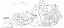
 | LaRue County is a county in the central region of the U.S. state of Kentucky, outside the Bluegrass Region and larger population centers. As of the 2020... 13 KB (1,064 words) - 02:20, 25 April 2024 |
 | Hodgenville is a home rule-class city in LaRue County, Kentucky, United States. It is the seat of its county. Hodgenville sits along the North Fork of... 13 KB (1,084 words) - 03:26, 16 March 2024 |
 | "Larrew" "LaRue" or "Larue", but other forms include "Larew", "LeRoux" and "LaRoux", "LaRu", "Laro", "Laroe", "l'Rue" and "l'Roe", "de la Rue" and "de la Rew"... 13 KB (1,639 words) - 22:58, 14 February 2024 |
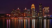 | Louisville metropolitan area (redirect from Louisville, Kentucky MSA) Knox, Kentucky MSA Hardin County, Kentucky (108,071) LaRue County, Kentucky (14,205) Principal city Louisville, Kentucky In 2003, the Jefferson County government... 26 KB (1,305 words) - 07:46, 13 April 2024 |
 | Abraham Lincoln Birthplace National Historical Park (category Museums in LaRue County, Kentucky) designated U.S. historic park preserving two separate farm sites in LaRue County, Kentucky, where Abraham Lincoln was born and lived early in his childhood... 14 KB (1,531 words) - 15:17, 28 April 2024 |
Larue or La Rue may also refer to: Larue, Arkansas, an unincorporated community La Rue, Illinois, an unincorporated community LaRue County, Kentucky LaRue... 859 bytes (134 words) - 08:56, 20 October 2023 |
John P. LaRue (1746–1792) was a Kentucky pioneer and member of the LaRue family of Virginia. John LaRue was the second child of Isaac and Phebe (Carman)... 4 KB (383 words) - 22:54, 30 December 2023 |
 | the Central Time Zone and Eastern Time Zone at the border of Hart and LaRue counties. For most of 2016, the Ohio River Bridges Project routed all I-65 traffic... 27 KB (1,714 words) - 19:49, 8 May 2024 |
 | Cumberland County to Columbia in Adair County through to Greensburg in Green County. From there, the route traverses LaRue, Hardin and Bullitt counties to terminate... 26 KB (653 words) - 16:59, 12 October 2023 |
Magnolia is a census-designated place and unincorporated community in LaRue County, Kentucky, United States. Its population was 524 as of the 2010 census. The... 5 KB (378 words) - 18:27, 14 August 2023 |
 | Upton is a home rule-class city in Hardin and LaRue counties in the U.S. state of Kentucky. The population was 704 as of the 2020 Census, up from 683 from... 9 KB (772 words) - 20:41, 14 November 2023 |
 | Knobs region (category Geography of LaRue County, Kentucky) Louisville, Kentucky and continues southeastward through Bullitt, Hardin, Nelson, LaRue, Marion County, Taylor, Boyle, Casey, Lincoln, and Garrard counties before... 3 KB (264 words) - 01:01, 11 December 2023 |
 | 18 and 9.1% of those age 65 or over. In 2000, Hardin County, Kentucky and LaRue County, Kentucky were defined as the Elizabethtown, KY Metropolitan Statistical... 36 KB (3,202 words) - 12:10, 11 May 2024 |
| Hardin County is a county located in the central part of the U.S. state of Kentucky. Its county seat is Elizabethtown. The county was formed in 1792. Hardin... 24 KB (2,165 words) - 02:17, 25 April 2024 |
 | U.S. Route 31E (redirect from U.S. Highway 37 (Kentucky)) parallel route for U.S. Highway 31 from Nashville, Tennessee, to Louisville, Kentucky. US 31E begins as the Ellington Parkway at the corner of Main Street and... 33 KB (1,342 words) - 01:29, 5 December 2023 |
 | Carl Brashear (category People from LaRue County, Kentucky) his life. Brashear was born on January 19, 1931, in Tonieville, LaRue County, Kentucky, the sixth of 16 children to sharecroppers McDonald and Gonzella... 24 KB (2,056 words) - 08:45, 3 May 2024 |
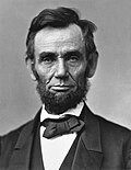 | Abraham Lincoln (category People from LaRue County, Kentucky) attack. Thomas then worked at odd jobs in Kentucky and Tennessee before the family settled in Hardin County, Kentucky, in the early 1800s. Lincoln's mother... 202 KB (22,642 words) - 20:36, 13 May 2024 |
 | Kentucky Route 1618 (KY 1618) is a 1.063-mile (1.711 km) state highway in LaRue County in the U.S. state of Kentucky. It begins at an intersection with... 2 KB (118 words) - 06:43, 22 June 2023 |
 | Jefferson (partial), LaRue, Logan (partial), McLean, Meade, Muhlenberg, Nelson (partial), Ohio, Warren. United States portal Kentucky's congressional districts... 52 KB (386 words) - 08:56, 3 May 2024 |
 | place (CDP) in southern LaRue County, Kentucky, United States. Its population was 498 as of the 2010 census. It lies along Kentucky Route 61 south of the... 4 KB (170 words) - 21:48, 7 July 2023 |
river in central Kentucky. The river flows through Marion and Hardin counties, as well as being the border between LaRue and Nelson counties. The Rolling... 5 KB (627 words) - 20:43, 26 October 2023 |
 | Nolin River (category Rivers of LaRue County, Kentucky) in western LaRue County by the confluence of its short North and South Forks, both of which flow for their entire lengths in LaRue County; the North Fork... 3 KB (374 words) - 00:57, 19 November 2022 |
Ginseng is an unincorporated community located in LaRue County, Kentucky, United States. The town was named for the crop ginseng, which was harvested by... 3 KB (91 words) - 05:51, 25 July 2023 |
LaRue County High School is a public school in Hodgenville, Kentucky. "LaRue County High School". National Center for Education Statistics. Retrieved... 1 KB (27 words) - 16:45, 19 January 2024 |
located in LaRue County, Kentucky, United States. Its post office is closed. U.S. Geological Survey Geographic Names Information System: Malt, Kentucky U.S.... 3 KB (40 words) - 04:03, 27 July 2023 |
 | which LaRue County, Daviess County, Bullitt County, Barren County, Breckinridge County, Hart County, Spencer County, Mason County, Fleming County, Todd... 82 KB (274 words) - 22:55, 13 March 2024 |
unincorporated community located in LaRue County, Kentucky, United States. U.S. Geological Survey Geographic Names Information System: White City, Kentucky v t e... 3 KB (27 words) - 05:37, 30 July 2023 |
Populated Place Profile / Larue County, Kentucky Data". kentucky.hometownlocator.com. "Welcome Message from LaRue County, Kentucky". www.laruecounty.org.... 2 KB (171 words) - 07:05, 29 July 2023 |
 | Atherton Whiskey (category LaRue County, Kentucky) within LaRue County, making them the largest product of Bourbon by volume in the United States. John M Atherton was a leader in the Kentucky distilling... 23 KB (2,051 words) - 17:44, 25 March 2024 |
 | U.S. Route 31W (redirect from U.S. Route 31W (Kentucky)) also marks the boundary between Robertson and Sumner Counties. The highway enters the state of Kentucky and crosses I-65 for a third time, where it passes... 32 KB (1,483 words) - 06:46, 25 February 2024 |