
Alpine, Bon Tempe, Lagunitas, and Nicasio reservoirs. The San Geronimo Valley is the last un-dammed headwater tributary of Lagunitas Creek. Each of the reservoirs...
17 KB (1,727 words) - 21:12, 21 February 2024
Lagunitas or Lagunita may refer to: Lagunitas, California, an unincorporated community in Marin County Lagunitas-Forest Knolls, California, a census-designated...
685 bytes (106 words) - 14:14, 22 November 2017
Ranges mountain system in California, United States. Olema Creek flows to Lagunitas Creek and thence to Tomales Bay and the Pacific Ocean. Olema is probably...
7 KB (530 words) - 19:39, 8 November 2023

of 217 feet (66 m). Lagunitas is aggregated with Forest Knolls by the U.S. Census into the census-designated place (CDP) Lagunitas-Forest Knolls. The first...
8 KB (690 words) - 06:53, 19 February 2024

primarily residential. The ZIP code of Lagunitas is 94938, while the ZIP code of Forest Knolls is 94933. Lagunitas-Forest Knolls is located at 38°0′54″N...
11 KB (1,096 words) - 06:00, 11 July 2023

Lake Lagunitas is a reservoir on Lagunitas Creek in Marin County, California. Lake Lagunitas is one of seven reservoirs providing potable water to the...
3 KB (249 words) - 01:19, 9 August 2023
SPAWN (section Lagunitas Creek watershed)
organization. SPAWN's stated mission is to "protect endangered salmon in the Lagunitas Creek Watershed and the environment on which we all depend." SPAWN uses a...
11 KB (1,338 words) - 22:59, 28 December 2022

villages of San Geronimo, Forest Knolls, and Lagunitas. It then turns southwestward and joins Lagunitas Creek at the eastern edge of the Samuel P. Taylor...
6 KB (463 words) - 03:04, 10 April 2023
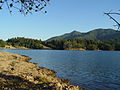
County, California formed by the construction of Peters Dam across Lagunitas Creek. Built in 1954 (70 years ago) (1954), the lake is the most recent lake...
4 KB (412 words) - 20:07, 11 February 2024

in the 1950s. In fall 2017 a half dozen chum salmon were counted in Lagunitas Creek about 25 miles (40 km) north of San Francisco, California. In the open...
14 KB (1,582 words) - 21:04, 3 May 2024
lake in the Mount Tamalpais watershed, and on Lagunitas Creek. Beneath its dam is Alpine Lake. Lake Lagunitas is immediately to its east. Built in 1948 (76 years...
3 KB (220 words) - 23:26, 5 August 2023

Salinas River. In the fall of 2017, a dozen pink salmon were counted in Lagunitas Creek about 25 miles (40 km) north of San Francisco, California. Pink salmon...
19 KB (2,140 words) - 10:00, 13 February 2024
Nicasio Creek is an 11.9-mile-long (19.2 km) stream in Marin County, California, United States and is the primary tributary of Lagunitas Creek, which flows...
9 KB (974 words) - 00:41, 26 September 2023
in Marin County, including Walker Creek, Lagunitas Creek, Miller Creek, and Novato Creek. Notably, the Lagunitas Creek Watershed is home to the largest...
91 KB (5,550 words) - 23:31, 9 May 2024
Lake Lagunita, informally referred to as Lake Lag, is an artificial dry lake in Stanford University, California, located on the western side of the Stanford...
5 KB (542 words) - 16:41, 28 March 2024
Dam on Lagunitas Creek Bon Tempe Lake on Lagunitas Creek Kent Lake, formed by Peters Dam on Lagunitas Creek Lake Lagunitas on Lagunitas Creek Nicasio...
8 KB (802 words) - 17:13, 29 April 2024

122.63806°W / 37.94028; -122.63806 Type Reservoir Primary outflows Lagunitas Creek Catchment area 10.2 square miles (26 km2) Basin countries United States...
5 KB (412 words) - 23:15, 5 August 2023
original (PDF) on October 5, 2012. Retrieved November 5, 2012. "Guadalupe Creek". Geographic Names Information System. United States Geological Survey,...
82 KB (562 words) - 10:22, 31 March 2024

more water from the Kent Dam in hopes of raising the levels in the Lagunitas Creek watershed—one of the last spawning grounds that wild coho can still...
39 KB (3,638 words) - 17:10, 12 April 2024
List of watercourses in the San Francisco Bay Area (redirect from Gill Creek)
(236446) Lagunitas Creek (255208) Olema Creek (234410) Nicasio Creek (229534) Halleck Creek (224814) Redwood Canyon (231415) San Geronimo Creek (232400)...
36 KB (2,909 words) - 01:05, 26 March 2024

Gold Rush and used some of his money to buy a parcel of land along Lagunitas Creek. In 1856, Taylor built the Pioneer Paper Mill, the first paper mill...
6 KB (480 words) - 17:13, 29 April 2024
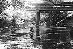
(also known as The Ink Wells) are two deep natural swimming pools in Lagunitas Creek, in Marin County, California. The upper Inkwell is also known as "Shafters"...
3 KB (236 words) - 03:29, 10 April 2023

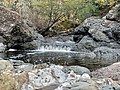
that is being experimented in streams such as Lagunitas Creek in Marin County, California and Thornton Creek, in Seattle, Washington. Log jams add diversity...
46 KB (5,127 words) - 21:56, 2 April 2024
Pennsylvania Lackawaxen River - Pennsylvania Lafayette River - Virginia Lagunitas Creek - California Lake River - Washington Lake Fork Mohican River - Ohio...
11 KB (943 words) - 17:52, 5 May 2024
concrete open-spandrel arch 1924 1981 Sir Francis Drake Boulevard Lagunitas Creek Lagunitas Marin 38°00′16″N 122°42′32″W / 38.00444°N 122.70889°W / 38...
55 KB (163 words) - 13:31, 9 May 2024

more water from the Kent Dam in hopes of raising the levels in the Lagunitas Creek watershed – one of the last spawning grounds that wild coho can still...
21 KB (2,129 words) - 00:24, 14 May 2024
in the Lagunitas Creek watershed, and the environment. The programmes projects include habitat restoration, fish rescue, citizen training, creek monitoring...
7 KB (703 words) - 19:19, 18 February 2024

(Oregonichthys kalawatseti), and Umpqua dace (Rhinichthys evermanni). The rivers and creeks of the ecoregion are home to several species of anadromous Pacific salmon...
5 KB (484 words) - 21:48, 23 January 2023

Trail. It includes a segment in Tocaloma as well as the bridge over Lagunitas Creek and Sir Francis Drake Boulevard. The NSR was operated by John Martin...
16 KB (1,133 words) - 20:56, 3 May 2024

Geological Survey (USGS). "United States Geological Survey Topographic Map: Lagunitas Creek, New Mexico quad". TopoQuest. Retrieved 2019-09-21. United States Geological...
6 KB (424 words) - 00:34, 1 November 2021