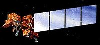
 | Landsat 7 is the seventh satellite of the Landsat program. Launched on 15 April 1999, Landsat 7's primary goal is to refresh the global archive of satellite... 13 KB (1,359 words) - 15:51, 2 March 2024 |
| eventually renamed to Landsat 1 in 1975. The most recent, Landsat 9, was launched on 27 September 2021. The instruments on the Landsat satellites have acquired... 41 KB (3,813 words) - 21:11, 5 January 2024 |
 | officially renamed to Landsat 8. With Landsat 5 retiring in early 2013, leaving Landsat 7 as the only on-orbit Landsat program satellite, Landsat 8 ensures the... 23 KB (2,253 words) - 14:58, 22 December 2023 |
 | Landsat 5 was a low Earth orbit satellite launched on March 1, 1984, to collect imagery of the surface of Earth. A continuation of the Landsat Program... 11 KB (1,099 words) - 03:33, 11 January 2024 |
 | Landsat 9 is an Earth observation satellite launched on 27 September 2021 from Space Launch Complex-3E at Vandenberg Space Force Base on an Atlas V 401... 10 KB (856 words) - 14:58, 22 December 2023 |
 | Satellite imagery (section Landsat) Landsat 5, thermal infrared imagery was also collected (at coarser spatial resolution than the optical data). The Landsat 7, Landsat 8, and Landsat 9... 25 KB (2,722 words) - 13:34, 14 April 2024 |
 | Landsat Island is a small, uninhabited island located at approximately 60°10'37"N 64°02'30"W, 20 kilometres (12 mi) off the northeast coast of Labrador... 3 KB (400 words) - 03:54, 13 April 2023 |
 | remote sensing instrument aboard Landsat 8, built by Ball Aerospace & Technologies. Landsat 8 is the successor to Landsat 7 and was launched on February 11... 6 KB (608 words) - 15:32, 8 January 2024 |
 | wavelengths simultaneously, instead of the seven measured by the imager in Landsat 7. This permitted a greater flexibility in false-color imagery. Another... 11 KB (947 words) - 14:56, 22 December 2023 |
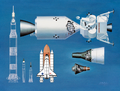 | completed Landsat 4, launched July 1982, completed Landsat 5, launched March 1984, completed Landsat 6, launched October 1993, failed Landsat 7, launched... 48 KB (3,980 words) - 15:14, 28 April 2024 |
 | Landsat 6, equipped with upgraded versions of the instruments on Landsat 5, was designed to carry forward the Landsat program. It was launched on October... 5 KB (368 words) - 23:34, 25 April 2024 |
 | Generation imagery Landsat 7 imagery NLT Landsat (Visible & Pseudo Color) Geocover 1990 & 2000 (pseudo; 1990 layer was produced from Landsat 4 & 5 images)... 20 KB (1,970 words) - 05:12, 6 April 2024 |
 | braided streams or settles into pools and ponds. Along the bottom of the Landsat 7 image on the right, the rugged terrain of the Brooks Range mountains is... 10 KB (1,050 words) - 09:50, 26 February 2024 |
 | satellite imagery. Unlike later Landsat satellites, Landsat 3 was managed solely by NASA. Landsat 3 decommissioned on September 7, 1983, beyond its design life... 12 KB (1,291 words) - 13:10, 19 November 2023 |
earlier than 2026. Its primary objective was the complex refueling of Landsat 7, a satellite launched in 1999. This would have involved grasping the satellite... 6 KB (577 words) - 04:58, 17 March 2024 |
p=7 in mathematics D-Lieferwagen L-7, a 1927–1930 German three-wheel truck IM L7, a 2022–present Chinese full-size luxury electric sedan Landsat 7, an... 1 KB (199 words) - 05:25, 4 January 2024 |
| Landsat 4 is the fourth satellite of the Landsat program. It was launched on July 16, 1982, with the primary goal of providing a global archive of satellite... 12 KB (1,237 words) - 15:31, 23 April 2024 |
 | type of sensor expensive and more prone to wearing out, such as in the Landsat 7. Whisk broom scanners have the effect of stopping the scan, and focusing... 2 KB (191 words) - 16:21, 14 January 2024 |
 | Landsat 7 false-color image of the Sydney area and surrounding suburbs. The image demonstrates how the built-up areas (pink) have been constrained by... 26 KB (1,288 words) - 08:32, 6 April 2024 |
 | Landsat 7 image Brandberg Mountain, Namibia... 13 KB (1,125 words) - 11:19, 29 February 2024 |
 | Landsat 1 (LS-1), formerly named ERTS-A and ERTS-1, was the first satellite of the United States' Landsat program. It was a modified version of the Nimbus... 12 KB (1,139 words) - 12:58, 9 April 2024 |
Before the launch of NASA and the USGS's Landsat 8 satellite, Google relied partially on imagery from Landsat 7, which suffered from a hardware malfunction... 94 KB (8,506 words) - 19:55, 15 April 2024 |
complex landscape in Kazakhstan: An object-based approach using SPOT-5 XS, Landsat 7 ETM+, SRTM and multiple Random Forests". International Journal of Applied... 11 KB (1,310 words) - 23:49, 31 January 2024 |
companies. As of 2022, there have been nine LandSat satellites with LandSat 7, 8, and 9 orbiting the Earth. The LandSat program has involved many organisations... 29 KB (1,997 words) - 14:56, 22 December 2023 |
 | ""Taklamakan" Adının Kökeni Üzerine". Korkut Ata Türkiyat Araştırmaları Dergisi (7): 572–577. doi:10.51531/korkutataturkiyat.1070366. ISSN 2687-5675. S2CID 248487312... 27 KB (2,361 words) - 18:57, 1 March 2024 |
of hurricanes. Notable pairs are GRACE and GRACE-Follow On satellites, Landsat 7 with EO-1, the "A-train" consisting of CALIPSO and CloudSat (among others)... 5 KB (466 words) - 13:21, 5 October 2023 |
combinations are commonly bundled in satellite data sets, for example Landsat 7, which includes six 30 m resolution multispectral bands, a 60 m thermal... 4 KB (498 words) - 02:48, 6 November 2023 |
 | States National Geospatial-Intelligence Agency. 2017. p. 15. "Imagery – Landsat 7 Path 118 Row 53". NASA. Retrieved March 21, 2014. "Award" (PDF). Permanent... 13 KB (1,217 words) - 00:30, 28 April 2024 |
 | awards. The Enhanced Thematic Mapper Plus (ETM+) instrument on NASA’s Landsat 7 satellite acquired this image of the Jwaneng Diamond Mine on May 17, 2001... 5 KB (560 words) - 07:10, 18 March 2024 |
International Earth Observation Constellation, with Argentine SAC-C and the U.S. Landsat 7, EO-1 and Terra missions. The satellite launched by CONAE was SAC-D/Aquarius... 27 KB (2,684 words) - 07:44, 18 April 2024 |