 | Landsat 8 is an American Earth observation satellite launched on 11 February 2013. It is the eighth satellite in the Landsat program; the seventh to reach... 23 KB (2,253 words) - 14:58, 22 December 2023 |
 | eventually renamed to Landsat 1 in 1975. The most recent, Landsat 9, was launched on 27 September 2021. The instruments on the Landsat satellites have acquired... 41 KB (3,813 words) - 21:11, 5 January 2024 |
| Landsat 7 is the seventh satellite of the Landsat program. Launched on 15 April 1999, Landsat 7's primary goal is to refresh the global archive of satellite... 13 KB (1,359 words) - 15:51, 2 March 2024 |
 | Landsat 9 is an Earth observation satellite launched on 27 September 2021 from Space Launch Complex-3E at Vandenberg Space Force Base on an Atlas V 401... 10 KB (856 words) - 14:58, 22 December 2023 |
 | Landsat 5 was a low Earth orbit satellite launched on March 1, 1984, to collect imagery of the surface of Earth. A continuation of the Landsat Program... 11 KB (1,099 words) - 03:33, 11 January 2024 |
 | remote sensing instrument aboard Landsat 8, built by Ball Aerospace & Technologies. Landsat 8 is the successor to Landsat 7 and was launched on February... 6 KB (608 words) - 15:32, 8 January 2024 |
 | Satellite imagery (section Landsat) Landsat 5, thermal infrared imagery was also collected (at coarser spatial resolution than the optical data). The Landsat 7, Landsat 8, and Landsat 9... 25 KB (2,722 words) - 13:34, 14 April 2024 |
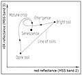 | weighted sum of the Landsat bands (without the thermal channel 6), where each band is multiplied by the specific coefficients. Early Landsat products: Brightness... 3 KB (465 words) - 17:41, 19 January 2024 |
 | August 2010, and the temperature was deduced from radiance measured by the Landsat 8 and other satellites. It was discovered during a National Snow and Ice... 27 KB (3,078 words) - 16:31, 27 April 2024 |
 | November 2004, operational Landsat program Landsat 1, launched July 1972, completed Landsat 2, launched January 1975, completed Landsat 3, launched March 1978... 48 KB (3,980 words) - 15:14, 28 April 2024 |
 | The Thematic Mapper (TM) sensor on Landsat 4 and Landsat 5 included a thermal (6th) band. Landsat 8 and Landsat-9 also acquires thermal data in two 10... 13 KB (1,272 words) - 14:24, 19 February 2024 |
companies. As of 2022, there have been nine LandSat satellites with LandSat 7, 8, and 9 orbiting the Earth. The LandSat program has involved many organisations... 29 KB (1,997 words) - 14:56, 22 December 2023 |
 | of scan swath. All sensors aboard the Landsat series of satellites used the whisk broom design until Landsat 8 which used a push broom sensor. Push broom... 2 KB (191 words) - 16:21, 14 January 2024 |
 | wavelengths simultaneously, instead of the seven measured by the imager in Landsat 7. This permitted a greater flexibility in false-color imagery. Another... 11 KB (947 words) - 14:56, 22 December 2023 |
| Landsat 4 is the fourth satellite of the Landsat program. It was launched on July 16, 1982, with the primary goal of providing a global archive of satellite... 12 KB (1,237 words) - 15:31, 23 April 2024 |
 | News, 9 December 2013. The Coldest Place on Earth: -90 °C and below from Landsat 8 and other satellite thermal sensors Archived 3 March 2016 at the Wayback... 188 KB (10,443 words) - 20:43, 29 April 2024 |
 | spatial resolution allows for continued collaboration with the SPOT-5 and Landsat-8 missions, with the core focus being land classification. Designed and... 19 KB (1,744 words) - 17:27, 21 April 2024 |
Synop Report Summary". Ogimet.com. Retrieved 5 August 2019. "NASA-USGS Landsat 8 Satellite Pinpoints Coldest Spots on Earth". Archived from the original... 11 KB (1,199 words) - 04:38, 26 March 2024 |
List of Atlas launches (2020–2029) (section Landsat 9) Security". United Launch Alliance. 18 May 2021. Retrieved 18 May 2021. "Landsat 8, 9 (LDCM)". "United Launch Alliance Successfully Launches Important Earth... 36 KB (1,094 words) - 02:12, 24 April 2024 |
 | Landsat 1 (LS-1), formerly named ERTS-A and ERTS-1, was the first satellite of the United States' Landsat program. It was a modified version of the Nimbus... 12 KB (1,139 words) - 12:58, 9 April 2024 |
 | 2021 satellite image of Bir Tawil (outlined in red) by Landsat 8... 14 KB (1,063 words) - 09:37, 20 April 2024 |
 | Chile was hit by the sixth largest recorded earthquake with a magnitude of 8.8 on the moment magnitude scale. The earthquake caused the death of 525 people... 144 KB (14,278 words) - 01:24, 26 April 2024 |
 | D24102. Bibcode:2009JGRD..11424102T. doi:10.1029/2009JD012104. "NASA-USGS Landsat 8 Satellite Pinpoints Coldest Spots on Earth". NASA. 9 December 2013. Retrieved... 10 KB (1,159 words) - 15:20, 12 February 2024 |
 | Bang Kachao as captured by the Landsat 8 satellite... 3 KB (376 words) - 04:09, 25 March 2024 |
volume. Earth observation data cubes combine satellite imagery such as Landsat 8 and Sentinel-2 with Geographic information system analytics. In online... 10 KB (1,239 words) - 19:36, 11 March 2024 |
 | in 2006 From the International Space Station on February 7, 2022 With Landsat 8 on March 20, 2022 Center for Menominee Language, Culture, and Art, Language... 15 KB (1,498 words) - 14:43, 25 March 2024 |
 | sulfur workers. Kawah Ijen volcano and crater lake, Java, viewed from Landsat 8 The sulfuric lake of Kawah Ijen Mountain's cauldron, Indonesia Mt. Merapi... 13 KB (1,234 words) - 12:06, 5 April 2024 |
 | these tools reduce field visits and enable better irrigation management. Landsat 8, Sentinel-2 and PlanetScope are some of the main providers of satellite... 27 KB (3,621 words) - 11:39, 31 December 2023 |
 | from the original on 4 December 2009. Retrieved 10 August 2017. "Landsat Science". Landsat.gsfc.nasa.gov. Retrieved 10 August 2017. "PROBA-V: The Small Satellite... 38 KB (1,190 words) - 11:41, 17 April 2024 |
 | (2018). "Detection of Pb–Zn mineralization zones in west Kunlun using Landsat 8 and ASTER remote sensing data". Journal of Applied Remote Sensing. 12... 64 KB (7,086 words) - 00:15, 21 April 2024 |