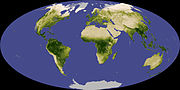
 | The Landsat program is the longest-running enterprise for acquisition of satellite imagery of Earth. It is a joint NASA / USGS program. On 23 July 1972... 41 KB (3,813 words) - 21:11, 5 January 2024 |
| Landsat 7 is the seventh satellite of the Landsat program. Launched on 15 April 1999, Landsat 7's primary goal is to refresh the global archive of satellite... 13 KB (1,359 words) - 15:51, 2 March 2024 |
 | Landsat 8 is an American Earth observation satellite launched on 11 February 2013. It is the eighth satellite in the Landsat program; the seventh to reach... 23 KB (2,253 words) - 14:58, 22 December 2023 |
 | distributes the data archive. It is the ninth satellite in the Landsat program, but Landsat 6 failed to reach orbit. The Critical Design Review (CDR) was... 10 KB (856 words) - 14:58, 22 December 2023 |
 | collect imagery of the surface of Earth. A continuation of the Landsat Program, Landsat 5 was jointly managed by the U.S. Geological Survey (USGS) and the... 11 KB (1,099 words) - 03:33, 11 January 2024 |
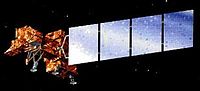
 | Landsat 1 (LS-1), formerly named ERTS-A and ERTS-1, was the first satellite of the United States' Landsat program. It was a modified version of the Nimbus... 12 KB (1,139 words) - 12:58, 9 April 2024 |
 | Landsat 3 is the third satellite of the Landsat program. It was launched on March 5, 1978, with the primary goal of providing a global archive of satellite... 12 KB (1,291 words) - 13:10, 19 November 2023 |
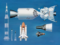 | List of NASA missions (redirect from NASA programs) November 2004, operational Landsat program Landsat 1, launched July 1972, completed Landsat 2, launched January 1975, completed Landsat 3, launched March 1978... 49 KB (4,040 words) - 16:20, 21 April 2024 |
| Landsat 4 is the fourth satellite of the Landsat program. It was launched on July 16, 1982, with the primary goal of providing a global archive of satellite... 12 KB (1,237 words) - 15:31, 23 April 2024 |
 | formats that image processing systems used in the early years of NASA's Landsat program. Thomas was born in Baltimore, Maryland. She graduated from high school... 11 KB (1,032 words) - 03:01, 4 April 2024 |
 | Landsat 6, equipped with upgraded versions of the instruments on Landsat 5, was designed to carry forward the Landsat program. It was launched on October... 5 KB (368 words) - 23:34, 25 April 2024 |
 | Apollo 11 missing tapes (redirect from Apollo program missing tapes) years immediately following the mission. In the early 1980s, NASA's Landsat program was facing a severe data tape shortage and it is likely the tapes were... 36 KB (3,629 words) - 18:00, 5 April 2024 |
 | Satellite imagery (section Landsat) among the public. Also in 1972 the United States started the Landsat program, the largest program for acquisition of imagery of Earth from space. In 1977,... 25 KB (2,722 words) - 13:34, 14 April 2024 |
 | Landsat Island is a small, uninhabited island located at approximately 60°10'37"N 64°02'30"W, 20 kilometres (12 mi) off the northeast coast of Labrador... 3 KB (400 words) - 03:54, 13 April 2023 |
 | to the Landsat program, having designed the Multispectral Scanner which was first used on Landsat 1. She has been called "The Mother of Landsat" for this... 12 KB (1,028 words) - 14:54, 21 April 2023 |
 | Landsat 2 is the second satellite of the Landsat program. The spacecraft originally carried a designation of ERTS-B (Earth Resource Technology Satellite... 11 KB (1,213 words) - 23:21, 25 April 2024 |
observing sensors introduced in the Landsat program. A Multispectral Scanner was placed aboard each of the first five Landsat satellites. The scanner was designed... 2 KB (152 words) - 01:03, 10 April 2023 |
NASA (redirect from NASA Applied Sciences Program) Command. The Landsat program is the longest-running enterprise for acquisition of satellite imagery of Earth. It is a joint NASA / USGS program. On July 23... 218 KB (20,358 words) - 05:36, 26 April 2024 |
Earth Observing System (category NASA programs) As of 2022, there have been nine LandSat satellites with LandSat 7, 8, and 9 orbiting the Earth. The LandSat program has involved many organisations since... 29 KB (1,997 words) - 14:56, 22 December 2023 |
September 23, 2022. "Landsat History". NASA. Retrieved July 5, 2021. Foust, Jeff (September 27, 2021). "Atlas 5 launches Landsat 9". Space News. Retrieved... 50 KB (3,087 words) - 00:55, 2 March 2024 |
Thematic Mapper, one of the Earth observing sensors introduced in the Landsat program Wisconsin H-Alpha Mapper, a custom-built 0.6 metres (24 in) telescope... 2 KB (245 words) - 22:17, 23 September 2023 |
Space policy of the United States (redirect from US space program) Administration operates various services with space components, such as the Landsat program. Military space activities are implemented by the United States Space... 55 KB (6,177 words) - 14:09, 9 April 2024 |
 | Landsat program photo with Mobile Bay in the center... 10 KB (1,218 words) - 06:51, 25 December 2023 |
 | found on Earth observation satellites, including (for example) the Landsat program or the IKONOS satellite. Maps of land cover and land use from thematic... 62 KB (7,676 words) - 12:12, 25 April 2024 |
Earth Observations Global Earth Observation System of Systems Phi Lab Landsat program TerraSAR-X: a German Earth observation satellite Radiant Earth Foundation:... 7 KB (733 words) - 07:03, 2 April 2024 |
 | Resources Technology Satellite (ERTS), which became the precursor to the Landsat program. These early sensors had minimal spectral resolution, but tended to... 27 KB (3,621 words) - 11:39, 31 December 2023 |
 | observation satellites (e.g. Landsat program, 1972), space telescopes and particularly space stations (e.g. Salyut program, 1971). The until 1979 negotiated... 255 KB (24,709 words) - 21:24, 27 April 2024 |
| November 11, 2009. Retrieved 2019-06-09. Mobile Bay National Estuary Program (November 2008). "State of Mobile Bay" (PDF). "Beneficial Uses of Dredge... 10 KB (1,167 words) - 22:00, 22 July 2023 |
 | intelligence-gathering services, including the Defense Support Program, Landsat program, SPOT, and six meteorological satellites. One area where the Coalition... 62 KB (4,968 words) - 02:17, 20 April 2024 |
 | November 2006 Rocchio, Laura. "The Landsat Program." National Aeronautics and Space Administration. http://landsat.gsfc.nasa.gov , accessed 4 December... 35 KB (4,561 words) - 00:50, 20 April 2024 |