a list of secondary highways in Sudbury District, most of which serve as logging roads or provide access to provincial parks and isolated areas in the...
7 KB (491 words) - 20:51, 31 March 2022

Timiskaming District, just outside Timmins. The Sudbury District also has a number of secondary provincial highways, which are the analogue in a district to county...
12 KB (958 words) - 22:03, 7 May 2024
This is a list of secondary highways in Nipissing District, many of which serve as logging roads or provide access to Algonquin Park and sparsely populated...
13 KB (782 words) - 22:20, 31 March 2021
This is a list of secondary highways in Thunder Bay District, most of which serve as logging roads or provide access to the isolated and sparsely populated...
30 KB (1,905 words) - 15:53, 3 September 2023
is a list of secondary highways in Kenora District, most of which provide access to isolated and sparsely populated areas in the Kenora District of northwestern...
30 KB (2,153 words) - 02:37, 7 July 2023
This is a list of secondary highways in Manitoulin District, which serve the isolated and sparsely populated areas in the Manitoulin District of Ontario...
11 KB (764 words) - 22:20, 31 March 2021
This is a list of secondary highways in Cochrane District, most of which serve as logging roads, mine and dam access roads, or provide access to isolated...
18 KB (1,354 words) - 10:20, 11 August 2022
is a list of secondary highways in Rainy River District, most of which serve isolated and sparsely populated areas in the Rainy River District of northwestern...
8 KB (525 words) - 15:52, 3 September 2023
This is a list of secondary highways in Timiskaming District, most of which serve as logging roads or provide access to the isolated and sparsely populated...
17 KB (982 words) - 16:49, 10 April 2023
a list of secondary highways in Algoma District, most of which serve as logging roads or provide access to isolated and sparsely populated areas in the...
32 KB (2,521 words) - 21:20, 16 January 2024
This is a list of secondary highways in Parry Sound District, many of which provide access to isolated settlements and recreational properties within...
25 KB (1,585 words) - 21:30, 1 September 2022
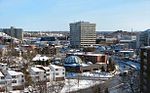
Sudbury, officially the City of Greater Sudbury, is the largest city in Northern Ontario by population, with a population of 166,004 at the 2021 Canadian...
128 KB (9,941 words) - 18:52, 14 May 2024

now the Municipality of Markstay-Warren in Sudbury District. The route was established, along with many other secondary highways, in 1956 and existed until...
5 KB (517 words) - 20:30, 12 May 2021

This article lists all of the numbered municipal roads in Greater Sudbury, Ontario. Municipal roads in Greater Sudbury are generally numbered with odd...
14 KB (226 words) - 05:36, 11 March 2023
This is a list of neighbourhoods in the urban core of Greater Sudbury, Ontario. This list includes only those neighbourhoods that fall within the pre-2001...
33 KB (3,857 words) - 06:35, 10 April 2024
of Ontario. In conjunction with Highway 400, it links Toronto with the city of Greater Sudbury at Highway 17, via Parry Sound. It is part of the Trans-Canada...
57 KB (4,519 words) - 18:43, 25 April 2024

region of Sudbury, the highway served to access Sudbury Airport. The designation was applied in 1956, along with many of the secondary highways in Ontario...
9 KB (801 words) - 19:24, 7 December 2021
the cities of Greater Sudbury and Timmins. The highway is one of the most isolated in Ontario, passing through forest for the majority of its 271 km (168 mi)...
14 KB (1,237 words) - 01:46, 22 January 2024

Manitoulin District, were also transferred to Sudbury District in 2006, about 1,600 square kilometres (600 sq mi) in all. The district has an area of 3,107...
15 KB (723 words) - 17:07, 9 February 2024

Ontario (with the lone exception being Greater Sudbury, which is in Northern Ontario), and are listed alphabetically by county, because more than one...
9 KB (551 words) - 22:41, 4 April 2024

Walden, Ontario (redirect from Creighton, Greater Sudbury, Ontario)
most of Ward 2 on Greater Sudbury City Council. Walden is part of the federal Sudbury electoral district, represented in the House of Commons of Canada...
36 KB (4,151 words) - 17:14, 24 March 2024
postcode districts List of electoral wards in Greater London List of civil parishes in Greater London Wikimedia Commons has media related to Districts of London...
59 KB (645 words) - 13:48, 6 May 2024
as part of the King's Highway, secondary highways, and tertiary roads. Components of the system—comprising 16,900 kilometres (10,500 mi) of roads and...
119 KB (11,363 words) - 00:38, 30 March 2024

assumed by the Department of Highways (DHO), predecessor to the modern MTO, in 1956, along with several dozen other secondary highways. It may have been provincially...
14 KB (1,266 words) - 15:12, 3 August 2023

The route of Highway 545 was first assumed by the Department of Highways in early 1956, along with several dozen other secondary highways. Throughout...
7 KB (719 words) - 20:28, 12 May 2021
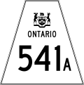
The route of Highway 541 was first assumed by the Department of Highways in early 1956, along with several dozen other secondary highways. The route...
6 KB (579 words) - 20:28, 12 May 2021
Provincial highways in Ontario include all roads maintained by the Ministry of Transportation as part of the Ontario Provincial Highway Network. Although...
118 KB (2,499 words) - 21:57, 27 February 2024

Northeastern Ontario (category Geography of Northern Ontario)
consists of the districts of Algoma, Sudbury, Cochrane, Timiskaming, Nipissing and Manitoulin. For some purposes, Parry Sound District and Muskoka District Municipality...
10 KB (466 words) - 16:00, 18 September 2023

Park. This route and most other secondary highways in the area were transferred to the Regional Municipality of Sudbury when it was established on January...
5 KB (471 words) - 20:32, 12 May 2021

Franco-Ontarians (redirect from Francophones in Ontario)
divisions (denoted in dark blue on the map) are designated areas in their entirety: Algoma District Cochrane District Greater Sudbury City of Hamilton Nipissing...
72 KB (8,396 words) - 16:59, 20 May 2024