 | A lock is a device used for raising and lowering boats, ships and other watercraft between stretches of water of different levels on river and canal waterways... 41 KB (4,929 words) - 05:52, 12 May 2024 |
items of importance Lock (water navigation), a device for boats to transit between different levels of water, as in a canal Lock (film), a 2016 Indian Punjabi-language... 4 KB (500 words) - 12:28, 26 April 2024 |
 | to the River Thames at Bow Creek; its first lock is Hertford Lock and its last Bow Locks. The Lee Navigation is named by Acts of Parliament and is so marked... 23 KB (2,485 words) - 14:13, 21 March 2024 |
 | changes in ambient pressure Mechanisms with similar functions: Lock (water navigation) – Uses water levels instead of air Revolving door – Regulates building... 15 KB (1,574 words) - 07:16, 3 March 2024 |
 | it included a clause that made the water companies responsible for the lock gates, because water from the navigation would be pumped to the reservoir,... 31 KB (3,864 words) - 11:09, 8 October 2023 |
 | The McClellan–Kerr Arkansas River Navigation System (MKARNS) is part of the United States inland waterway system originating at the Tulsa Port of Catoosa... 18 KB (1,393 words) - 17:08, 21 June 2023 |
the size or the draft of the ship being contemplated for navigation and the seasonal water level. On others, it is quite objective, being caused by a... 2 KB (287 words) - 14:21, 15 May 2023 |
 | locks. The lowest lock was at Woodmill, where the navigation joined the estuary of the River Itchen, on its way to Southampton Water. The main wharves... 43 KB (5,893 words) - 16:29, 11 May 2024 |
 | Wakefield, by the construction of 16 locks. Lock sizes were increased several times, as was the depth of water, to enable larger boats to use the system... 34 KB (4,371 words) - 01:07, 24 March 2024 |
 | Weybridge on the Wey Navigation had an additional single gate some 100 yards (91 m) below the lock, which when closed raises the water level above it, allowing... 9 KB (991 words) - 16:21, 2 May 2024 |
 | Dam (redirect from Dammed water) List of largest dams List of tallest dams List of tidal barrages Lock (water navigation) – Device for raising and lowering boats or ships Reservoir safety –... 92 KB (11,053 words) - 15:07, 1 February 2024 |
 | Forth and Clyde Canal (redirect from Forth and Clyde Navigation) Lower Lock. 35 36 – No. 36 Drop Lock – Dalmuir Drop Lock (constructed recently to take navigation below bridge) 37 – Old Kilpatrick 38 – Dalnottar Lock No... 32 KB (2,886 words) - 21:23, 28 November 2023 |
 | River Avon, Bristol (redirect from Avon Navigation) the Avon Navigation. The Avon above Bath remains navigable as far as Bathampton where there is the remains of a flash lock. However, the lock past the... 67 KB (6,136 words) - 16:45, 11 May 2024 |
 | Waterway System, and is used to control water diversion from Lake Michigan into the river and for navigation. The lock was built between 1936 and 1938 by the... 6 KB (491 words) - 23:56, 1 December 2023 |
 | has the lock keeper's cabin and the weir pool, Teddington Lock Footbridge. The Navigation Act obtained in April 1771 by the Thames Navigation Commission... 23 KB (2,648 words) - 20:08, 13 April 2024 |
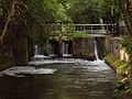
 | by the London Stone. The principle of lock/weir combination, which maintained the depth of water for navigation and reduced the danger of flooding, was... 19 KB (1,780 words) - 18:15, 13 November 2023 |
 | waterway. The final lock is Lower Lock, after which the navigation joins the Lee Navigation, just to the north of Feilde's Weir Lock. Wikimedia Commons... 24 KB (3,011 words) - 18:09, 31 January 2024 |
 | Aspinwall. The lock and dam were built by the U.S. Army Corps of Engineers as a part of an extensive system of locks and dams to improve navigation along the... 4 KB (361 words) - 05:45, 7 November 2023 |
 | River Weaver (redirect from Weaver Navigation) reach the River Mersey at most states of the tide, as the water was deeper. The navigation was completely reconstructed between 1870 and 1900, with the... 47 KB (6,331 words) - 16:20, 4 February 2024 |
 | the lock is gone. There were originally eight locks along the navigation. Each lock chamber was 13 feet wide by 65 feet long. Throstles Nest Lock was... 11 KB (1,182 words) - 08:56, 5 September 2023 |
 | section. A red band indicates that water levels are sufficiently high that the lock has been closed, and navigation on the river is unsafe. Map all coordinates... 22 KB (3,016 words) - 16:25, 26 April 2024 |
 | Schuylkill Canal (redirect from Schuylkill Navigation Company) The Schuylkill Canal, or Schuylkill Navigation, was a system of interconnected canals and slack-water pools along the Schuylkill River in the U.S. state... 38 KB (4,198 words) - 11:37, 8 February 2024 |
 | River Cam (redirect from Bottisham Lock) who call themselves the Camboaters. Navigation on the lowest section of the Cam, below and including Bottisham Lock,map 2 is the responsibility of the... 31 KB (3,795 words) - 15:12, 17 April 2024 |
 | Thames lock is used when Thames water level is low; it may have been added because the Thames was still slightly tidal at this point when the navigation was... 29 KB (3,643 words) - 22:13, 15 August 2023 |
 | to the shareholders in 1927. With the demise of navigation and the decay of the lock structures, water levels are considerably lower than they once were... 31 KB (3,990 words) - 16:26, 31 January 2024 |
 | River Ouse, Sussex (redirect from Ouse Navigation) There is also a lock marked on the river, though this was presumably a flash lock. Smeaton's plan for a sluice and navigation lock at Piddinghoe had... 63 KB (8,627 words) - 09:32, 6 December 2023 |
 | River Gipping (redirect from Ipswich and Stowmarket Navigation) restoring parts of the towpath between Paper Mill Lock and Badley Lock and concentrating their navigational restoration efforts on the 2.5 mile stretch of... 43 KB (5,738 words) - 09:50, 12 April 2024 |
 | River Trent (redirect from River Trent Navigation) construction of Cromwell Lock began in 1908. The Newark Navigation Commissioners financed improvements to Newark Town lock at the same time, and dredging... 156 KB (15,696 words) - 19:38, 30 March 2024 |
 | River Nene (redirect from River Nene, Norfolk: Navigation Act 1724) Cambridge via Whittlesey and Ely. The branch terminates, for navigation, at Stanground Lock, a connection to the Middle Levels, the drainage system of the... 40 KB (4,924 words) - 22:05, 4 May 2024 |
 | Kennet and Avon Canal (section River navigations) stretch is Garston Lock, the other turf-sided lock on the navigation. Shortly after passing Fobney Lock and the associated water treatment works, the... 101 KB (10,320 words) - 12:13, 28 March 2024 |